Search
You Searched For
Search Results
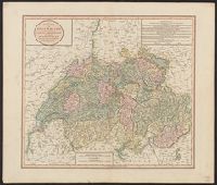
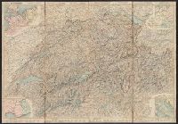
- Published / Created:
- 1811
- Call Number:
- 37 1811
- Image Count:
- 1
- Resource Type:
- Maps, Atlases & Globes
- Found in:
- Beinecke Rare Book and Manuscript Library > A new map of Swisserland ... By John Cary, Engraver.
- Creator:
- Ettling, Theodor, b. 1823
- Published / Created:
- 1860
- Call Number:
- 40 1860
- Container / Volume:
- BRBL_00201
- Image Count:
- 1
- Resource Type:
- Maps, Atlases & Globes
- Found in:
- Beinecke Rare Book and Manuscript Library > Map of Italy and Switzerland [cartographic material] / by T. Ettling.
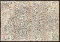
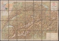
- Published / Created:
- [1852]
- Call Number:
- 37 1852
- Image Count:
- 1
- Resource Type:
- Maps, Atlases & Globes
- Found in:
- Beinecke Rare Book and Manuscript Library > Map of the Republic of Switzerland describing the Twenty-Two Cantons including those of Le Valois, Geneva and Neuchatel, exhibiting the various objects interesting to the traveller / compiled from the surveys of Weiss, Kellar &c.
- Creator:
- Leuthold, H. F
- Published / Created:
- 1860
- Call Number:
- 37 1860A
- Image Count:
- 2
- Resource Type:
- Maps, Atlases & Globes
- Found in:
- Beinecke Rare Book and Manuscript Library > Roadmap of Switzerland = Reisekarte der Schweiz = Carta stradale della Svizzera = Carte routière de la Suisse : en partie tirée de l'atlas topographique de la confederation / dresée et gravée par Mullhaupt ; publiée par H.F. Leuthold editeur ; ecrit
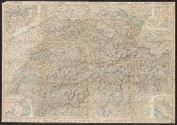
- Creator:
- Leuthold, H. F
- Published / Created:
- 1861
- Call Number:
- 37 1861A
- Image Count:
- 2
- Resource Type:
- Maps, Atlases & Globes
- Found in:
- Beinecke Rare Book and Manuscript Library > Roadmap of Switzerland = Reisekarte der Schweiz = Carta stradale della Svizzera = Carte routière de la Suisse : en partie tirée de l'atlas topographique de la confederation / dresée et gravée par Mullhaupt ; publiée par H.F. Leuthold editeur ; ecrit
- Creator:
- Leuthold, H. F
- Published / Created:
- 1858
- Call Number:
- 37 1858
- Image Count:
- 2
- Resource Type:
- Maps, Atlases & Globes
- Found in:
- Beinecke Rare Book and Manuscript Library > Roadmap of Switzerland = Reisekarte der Schweiz = Carta stradale della Svizzera = Carte routière de la Suisse : en partie tirée de l'atlas topographique de la confederation / dresée et gravée par Mullhaupt ; publiée par H.F. Leuthold editeur ; ecrit
- Creator:
- Leuthold, H. F
- Published / Created:
- 1867
- Call Number:
- 37 1867
- Image Count:
- 2
- Resource Type:
- Maps, Atlases & Globes
- Found in:
- Beinecke Rare Book and Manuscript Library > Roadmap of Switzerland = Reisekarte der Schweiz = Carta stradale della Svizzera = Carte routière de la Suisse : en partie tirée de l'atlas topographique de la confederation / dresée et gravée par Mullhaupt ; publiée par H.F. Leuthold editeur ; ecrit
- Creator:
- Leuthold, H. F
- Published / Created:
- 1856
- Call Number:
- 37 1856
- Image Count:
- 2
- Resource Type:
- Maps, Atlases & Globes
- Found in:
- Beinecke Rare Book and Manuscript Library > Roadmap of Switzerland = Reisekarte der Schweiz = Carta stradale della Svizzera = Carte routière de la Suisse : en partie tirée de l'atlas topographique de la confederation / dresée et gravée par Mullhaupt ; publiée par H.F. Leuthold editeur ; ecrit
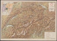
- Creator:
- Kümmerly + Frey
- Published / Created:
- 1907
- Call Number:
- 37 1907A
- Container / Volume:
- BRBL_00149
- Image Count:
- 1
- Resource Type:
- Maps, Atlases & Globes
- Found in:
- Beinecke Rare Book and Manuscript Library > Swiss Federal Railways tourist map of Switzerland / Geogr. Establishment Kümmerly & Frey.
- Creator:
- Kümmerly + Frey
- Published / Created:
- 1909
- Call Number:
- 37 1909A
- Container / Volume:
- BRBL_00149
- Image Count:
- 2
- Resource Type:
- Maps, Atlases & Globes
- Found in:
- Beinecke Rare Book and Manuscript Library > Swiss Federal Railways tourist map of Switzerland / Geogr. Establishment Kümmerly & Frey.