Skip to search
Skip to main content
Skip to first result
Search
You Searched For
Access
Public
Format
cartographic
Language
English
New Search
Search Results
Published / Created:
188-]
Call Number:
754GM 1880
Container / Volume:
BRBL_00419
Image Count:
1
Resource Type:
Maps, Atlases & Globes
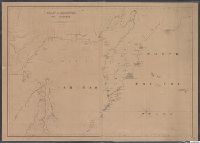
Alternative Title:
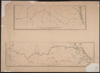
Enlarged map of Central transportation route and Enlarged map of Southern transportation route
Publisher:
s.n.,
Subject (Geographic):
Southern States (U.S.)--Maps
Found in:
Beinecke Rare Book and Manuscript Library > [Two maps showing the southern Atlantic states to point out the transportation routes to the Seaboard Central and Seaboard Southern routes].
Published / Created:
1840-1844.
Call Number:
23 1844
Container / Volume:
BRBL_00020
Image Count:
3
Resource Type:
Maps, Atlases & Globes
Description:
Islands of Fakaafo or Bowditch ca. 1:300,000; Nuku-Nono or Duke of Clarence 1:75,000; Oatáfu or Duke of York 1:75,000; Swains, Jarvis, Birnies, Enderbury, Hull, New York or Washington all ca. 1:75,000; Funafuti or Ellices, Nukufetau o and Preliminary record.
Subject (Geographic):
Oceania--Maps
Found in:
Beinecke Rare Book and Manuscript Library > [U.S. Exploring Expedition Pacific Ocean] Engraved by Sherman and Smith, New York. By the U.S. Ex.Ex.
Published / Created:
1848?]
Call Number:
75 1848C
Container / Volume:
BRBL_00399
Image Count:
1
Resource Type:
Maps, Atlases & Globes
Description:
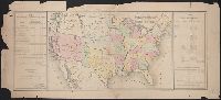
Prepared for the President of the United States ...
Subject (Geographic):
United States--Maps
Found in:
Beinecke Rare Book and Manuscript Library > [United States Treaties] E. Gilman, draftsman. P.S. Duval's Steam lith. press, Philadelphia.
Published / Created:
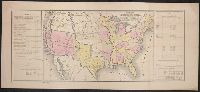
1848?]
Call Number:
75 1848B
Container / Volume:
BRBL_00399
Image Count:
1
Resource Type:
Maps, Atlases & Globes
Subject (Geographic):
United States--Maps
Found in:
Beinecke Rare Book and Manuscript Library > [United States Treaties] E. Gilman, draftsman. P.S. Duval's Steam lith. press, Philadelphia.
Published / Created:
1866
Call Number:
75 1866H
Container / Volume:
BRBL_00403
Image Count:
1
Resource Type:
Maps, Atlases & Globes
Publisher:
U.S. Coast Survey Office,
Subject (Geographic):
United States--Maps
Found in:
Beinecke Rare Book and Manuscript Library > [United States] / drawn by A. Lindenkohl ; Chas. G. Krebs, Litho.
Published / Created:
[1920?].
Call Number:
75 1920
Container / Volume:
BRBL_00407A
Image Count:
2
Resource Type:
Maps, Atlases & Globes
Description:
Various information on borders; shows time zones. and Verso: Central part city of Washington and other data, etc.
Publisher:
Rand, McNally & Co.,
Subject (Geographic):
United States--Maps
Found in:
Beinecke Rare Book and Manuscript Library > [United States] / printed by Rand McNally & Company for free distribution through the newspapers represented by Frederic J. Haskin ; photographs by Harris & Ewing.
Published / Created:
c1902.
Call Number:
75gme 1915
Container / Volume:
BRBL_00414A
Image Count:
1
Resource Type:
Maps, Atlases & Globes
Description:
Insets of U.S. Possessions.
Publisher:
Poole Bros.,
Subject (Geographic):
United States--Maps
Found in:
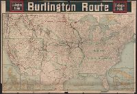
Beinecke Rare Book and Manuscript Library > [United States] Burlington Route / Burlington R.R.
Published / Created:
[1940?]
Call Number:
38gmp B833 1940
Container / Volume:
BRBL_00171
Image Count:
1
Resource Type:
Maps, Atlases & Globes
Description:
Aerial photograph of portion of Bruges railway., Imperfect: Frayed with loss of text., and Title supplied by cataloger.
Publisher:
Advanced Section, Army Printing and Stationery Service,
Subject (Geographic):
Belgium--Maps
Found in:
Beinecke Rare Book and Manuscript Library > [View taken above Bruges].
Published / Created:
1855
Call Number:
811ca 1855
Container / Volume:
BRBL_00554
Image Count:
1
Resource Type:
Maps, Atlases & Globes
Description:
"Entered according to act of Congress by E.J. Hulbert in the year 1855 in the Clerk's Office of the District Court of the United States for the State of Michigan". and Imperfect: Mutilated with some loss of text.
Publisher:
s.n.,]
Subject (Geographic):
Michigan--Maps
Found in:
Beinecke Rare Book and Manuscript Library > [Western part of upper peninsula, Michigan].
Published / Created:
1845
Call Number:
54635cea 1845
Container / Volume:
BRBL_00290
Image Count:
2
Resource Type:
Maps, Atlases & Globes
Description:
Preliminary record.
Publisher:
W.C. Taber & Son,
Subject (Geographic):
Kamchatskai︠a︡ oblastʹ (Russia)--Maps--Early works to 1800
Found in:
Beinecke Rare Book and Manuscript Library > [Whaling] Chart of Kamscatka, and the Sea of Ochotsk. Copied from the best Russian Authorities. ... respectfully dedicated to the Whaling Fleet of the United States.
Branch:v1.61.8 ,Deployed:2024-06-20T11:14:48-04:00