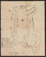
4 copies of positive photostat., Color: pen and ink., and Drawn by James Blake about 1728 in order to place the milestone - now standing erected by Gov. Belcher, 1881.
Subject (Geographic):
Boston (Mass.)--Maps, Manuscript--Early works to 1800
"This plan represents seven hundred acres of Juniper swamp Binding on the S.W. side of North River beginning at the head of Sawing Creek at a Cypress and Running as appears by this plot. Surveyed the 10th September 1762/", Color: pen and ink drawing., and Measured in chains.
Subject (Geographic):
North Carolina--Maps, Manuscript--Early works to 1800
Mounted on paper. Included with "An essay towards a description of Bath." Annotation: "Copy of Johnson's plan (1634) with explanation from Wood's 'Essay,' 1742. Bath." and Title supplied by cataloger.
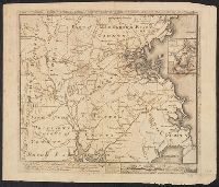
In upper right corner: Gent. Mag., Prime meridian: London., Relief shown pictorially and with hachures., Removed from: Gentleman's magazine. [June 1763]., Sheet measures 20.4 x 26.9 cm. Cross Collection no. 186., and Shows locations of North American Indian tribes.
Publisher:
Gentleman's Magazine,
Subject (Geographic):
Mississippi River Valley--Maps--Early works to 1800 and North America--Maps--Early works to 1800
Subject (Topic):
Indians of North America--Maps--Early works to 1800
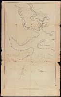
Coordinates not present on map and are approximated., Depths shown by soundings., From the Nathaniel Pendleton family papers., North oriented towards the right., Shows channel between Cumberland and Amelia Islands on the Georgia/Florida border where the Saint Marys River flows out to the Atlantic., Title devised by cataloger., and Watermark.
Subject (Geographic):
Saint Marys River (Ga. and Fla.)--Maps--Early works to 1800.
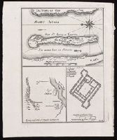
[Top] Chart of the island of Saint Louis showing location of the Fort St. Louis, the reservoir, and dwellings in western Africa; [bottom left] Chart of the location of Fort St. Joseph in Bakel, Senegal, on the Senegal River; [bottom right] Plan of the Fort St. Joseph.
Alternative Title:
Egnen fra fortet St. Joseph til Galam and Grundridsning of fortet St. Joseph
Description:
"No. 14" in upper right corner; "III.D." in lower right corner., Coordinates not present on map and are approximated., From Almindelig histoirie over reiser til lands og bands ... (Kjøbenhavn: Niels Hansen Møller, 1749), a translation of Collection of voyages and travels edited by Awnsham Chruchill and Thomas Osborne., North oriented towards the left on first map., Relief shown pictorially., and Title of first map devised by cataloger.
Publisher:
[Niels Hansen Møller],
Subject (Geographic):
Bakel (Senegal : Department)--Maps--Early works to 1800. and Saint-Louis (Senegal)--Maps--Early works to 1800.
Subject (Name):
Churchill, Awnsham, -1728. Collection of voyages and travels. Danish., Møller, Niels Hansen, and Osborne, Thomas, -1767. Collection of voyages and travels. Danish.