Skip to search
Skip to main content
Skip to first result
Search
You Searched For
Format
cartographic
Language
English
New Search
Search Results
Published / Created:
1818
Call Number:
18bh 1818
Container / Volume:
BRBL_00013
Image Count:
1
Resource Type:
Maps, Atlases & Globes
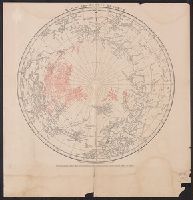
Description:
2 copies. and Preliminary record.
Publisher:
Published as the Act directs, by John Murray,
Subject (Geographic):
Arctic Regions--Maps
Found in:
Beinecke Rare Book and Manuscript Library > Map of the Arctic Regions. Circumpolar Map no. II (Geographical Discoveries made since 1818 in Red).
Published / Created:
1818
Call Number:
18bh 1818
Container / Volume:
BRBL_00013
Image Count:
1
Resource Type:
Maps, Atlases & Globes
Description:
2 copies. and Preliminary record.
Publisher:
Published as the Act directs, by John Murray,
Subject (Geographic):
Arctic Regions--Maps
Found in:
Beinecke Rare Book and Manuscript Library > Map of the Arctic Regions. Circumpolar Map no. II (Geographical Discoveries made since 1818 in Red).
Creator:
Published / Created:
1914
Call Number:
44 1914A
Container / Volume:
BRBL_00256
Image Count:
1
Resource Type:
Maps, Atlases & Globes
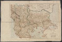
Alternative Title:
Geographic journal. [Offprint] and Geographic journal. Offprint.
Description:
From the Geographical Journal, May, 1914. and Relief shown by shading and spot heights.
Publisher:
Royal Geographical Society,
Subject (Geographic):
Balkan Peninsula--Maps
Found in:
Beinecke Rare Book and Manuscript Library > Map of the Balkan States showing frontiers in accordance with the treaties and agreements of 1913-14 [cartographic material].
Published / Created:
1863
Call Number:
774hc G33 1863W
Container / Volume:
BRBL_00502
Image Count:
1
Resource Type:
Maps, Atlases & Globes
Description:
7th Edition.
Publisher:
PS Duval & Son ,
Subject (Geographic):
Gettysburg Battlefield (Pennsylvania)--Maps
Found in:
Beinecke Rare Book and Manuscript Library > Map of the Battle of Gettysburg, Pa., July 1st, 2nd, and 3rd, 1863 ; showing line of Battle on PM. of 2d. / Prepared by W.H. Willcox. Capt. & A.D.C. on Maj. Genl. Reynold's Staff.
Creator:
Published / Created:
1870
Call Number:
754gme 1870
Container / Volume:
BRBL_00420
Image Count:
1
Resource Type:
Maps, Atlases & Globes
Description:
Shows railroads, railroads in progress of construction, and contemplated railroads.
Publisher:
Geo. F. Leefe, Lith.,
Subject (Geographic):
Eastern United States--Maps
Found in:
Beinecke Rare Book and Manuscript Library > Map of the Bellefontaine and Indiana rail road : with connections.
Creator:
Published / Created:
1887
Call Number:
844ad Al11 1887
Container / Volume:
BRBL_00612
Image Count:
1
Resource Type:
Maps, Atlases & Globes
Alternative Title:
Map of the Black and Rose tracts, Alameda, Co., Cal.
Description:
"Stanley & Bartlett, agents, Pleasanton, Cal.", Blue line print., and Cadastral map.
Publisher:
MacCabe & Co.?],
Subject (Name):
MacCabe & Co and Stanley & Bartlett (Pleasanton, Calif.)
Subject (Topic):
Real property--California--Alameda County--Maps
Found in:
Beinecke Rare Book and Manuscript Library > Map of the Black & Rose tracts, Alameda Co., Cal. / Geo. L. Nusbaumer, county surveyor.
Published / Created:
1854
Call Number:
774 M441 1854
Container / Volume:
BRBL_00499
Image Count:
4
Resource Type:
Maps, Atlases & Globes
Description:
In 4 sections. and Preliminary record.
Publisher:
Jos. B. Craig,
Subject (Geographic):
Pennsylvania--Maps
Found in:
Beinecke Rare Book and Manuscript Library > Map of the Borough and Township of Manchchunk including plans of Nesquehoning Summit Hill, the borough of Tamaqua and the coal works of the Lehigh coal and Navigan, Co. in the counties of Carbon and Schnykill, Pa. surveyed and drawn by Phillip Nunan
Creator:
Published / Created:
1913
Call Number:
771 B796 1913
Container / Volume:
BRBL_00481
Image Count:
1
Resource Type:
Maps, Atlases & Globes
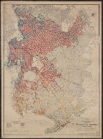
Description:
Asphalt, brick and iron slag, belgian block, medina sandstone, macadam, and wood blook pavements are shown., Identifies streets, blocks, paths, neighborhoods, parks, cemeteries, hotels, waterways, public buildings, and race tracks., and Pavement types identifie
Publisher:
A.R. Ohman Map Co.
Subject (Geographic):
Brooklyn (New York, N.Y.)--Maps and New York (N.Y.)--Maps
Subject (Name):
Brooklyn (New York, N.Y.). Office of Brooklyn Borough President, Ohman Map Co, Petersen, H.Buchardt. Pres. A.R.Ohman Map Co., New York, N.Y, Pounds, Lewis H. Acting Commissioner of Public Works, and Steers, Alfred E. Pres. Borough of Brooklyn
Subject (Topic):
Public works--Brooklyn (New York, N.Y.)--Maps and Roads--Brooklyn (New York, N.Y.)--Maps
Found in:
Beinecke Rare Book and Manuscript Library > Map of the Borough of Brooklyn, City of New York [cartographic material]: showing street pavements other than cobblestone on January 1st, 1913./ Office of the President of the borough of Brooklyn, [and] Bureau of Highways.
Creator:
Published / Created:
1885
Call Number:
753gme 1885
Container / Volume:
BRBL_00415
Image Count:
2
Resource Type:
Maps, Atlases & Globes
Alternative Title:
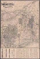
Boston & Lowell Railroad :
Description:
Covers New England excluding Maine, and portions of eastern New York and southern Québec., Includes text and adv. for "The Merrimack Valley Route" along left margin., Inset map of "The White Mountain District of the Boston & Lowell R.R.", and On verso: timetabl
Publisher:
Rand Avery Supply Co.,
Subject (Name):
Boston and Lowell Railroad Corporation--Maps
Subject (Topic):
Railroads--New England--Maps
Found in:
Beinecke Rare Book and Manuscript Library > Map of the Boston & Lowell Railroad System : with its principal connections.
Published / Created:
1849
Call Number:
76gme 1849P
Container / Volume:
BRBL_00446A
Image Count:
1
Resource Type:
Maps, Atlases & Globes
Description:
George B. Parrott, Del. On stone by C.A. Swett.
Publisher:
W.C. Sharp's Lith.,
Subject (Geographic):
New England--Maps
Found in:
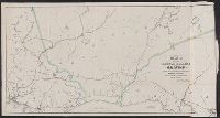
Beinecke Rare Book and Manuscript Library > Map of the Boston and Maine Railroad showing its relative position & connection with other Railroads. Prepared by order of the Committee of Investigation. Wm. Parrott, Engineer.
Branch:v1.61.6 ,Deployed:2024-06-12T09:55:19-04:00