Skip to search
Skip to main content
Skip to first result
Search
You Searched For
Format
cartographic
Language
English
New Search
Search Results
Published / Created:
1900?]
Call Number:
80gme 1900
Container / Volume:
BRBL_00540
Image Count:
1
Resource Type:
Maps, Atlases & Globes
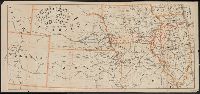
Description:
Covers area from Colorado to Illinois, through Nebraska, Iowa, Kansas, and Missouri. and In lower right margin: Shober & Carqueville Lith. Co. Chicago.
Publisher:
Shober & Carqueville?,
Subject (Name):
Chicago, Burlington & Quincy Railroad Company--Maps and Shober & Carqueville
Subject (Topic):
Railroads--Middle West--Maps
Found in:
Beinecke Rare Book and Manuscript Library > Map of the Chicago, Burlington and Quincy R.R. and its connections.
Creator:
Published / Created:
1868
Call Number:
80gme 1868B
Container / Volume:
BRBL_00538
Image Count:
1
Resource Type:
Maps, Atlases & Globes
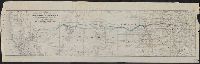
Description:
Relief shown by hachures.
Publisher:
R. Blanchard?],
Subject (Name):
Chicago, Rock Island and Pacific Railroad Company (1866-1880)--Maps
Subject (Topic):
Railroads--West (U.S.)--Maps
Found in:
Beinecke Rare Book and Manuscript Library > Map of the Chicago, R.I. & Pacific R.R. : Chicago to Council Bluffs with its branches and western r.r. connections / engr. by Rufus Blanchard, Chicago, Ill.
Published / Created:
1907
Call Number:
75gme 1907
Container / Volume:
BRBL_00414
Image Count:
1
Resource Type:
Maps, Atlases & Globes
Description:
"4760 ; 7-1-'07."
Publisher:
Poole Bros.,
Subject (Geographic):
United States--Maps
Found in:
Beinecke Rare Book and Manuscript Library > Map of the Chicago, St. Paul, Minneapolis & Omaha Ry. and Chicago & North Western Ry.
Creator:
Published / Created:
[1944]
Call Number:
56fd 1944
Container / Volume:
BRBL_00298
Image Count:
1
Resource Type:
Maps, Atlases & Globes
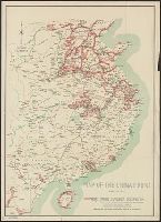
Description:
Covers eastern China, southward from Chahar-Jehol (present Inner Mongolia) to Hainan and eastward from Szechwan to East China Sea., Includes inset showing China/Burma border area., Relief shown by hachure, and Shows Chinese territories under Japanese occupation.
Publisher:
Chinese Ministry of Information,
Subject (Geographic):
China--Maps
Subject (Topic):
Sino-Japanese War, 1937-1945--Occupied territories--Maps
Found in:
Beinecke Rare Book and Manuscript Library > Map of the China front [cartographic material] : January, 1944 / Chinese Ministry of Information, London Office.
Published / Created:
1853
Call Number:
804gme 1853
Container / Volume:
BRBL_00545
Image Count:
1
Resource Type:
Maps, Atlases & Globes
Description:
"Drawn by T. Lincoln".
Publisher:
Klauprecht & Menzel's, Lith.,
Subject (Geographic):
Ohio--Maps
Found in:
Beinecke Rare Book and Manuscript Library > Map of the Cincinnati, Hamilton & Dayton railroad and connecting lines. / R.M. Shoemaker, Chief Engineer.
Published / Created:
1830
Call Number:
766 N46 1830
Container / Volume:
BRBL_00470
Image Count:
1
Resource Type:
Maps, Atlases & Globes
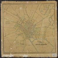
Description:
Inset, in circle 9cm. in diameter: Fair Haven, the Eastern Section of New Haven City. and The map is colored by hand, parks being green.
Publisher:
Jocelyn, Darling & Co.,
Subject (Geographic):
New Haven (Conn.)--Maps
Found in:
Beinecke Rare Book and Manuscript Library > Map of the City of New Haven from actual survey by D.W. Buckingham, county surveyor.
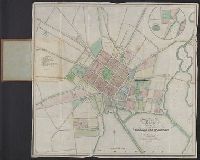
Published / Created:
1830
Call Number:
766 N46 1830
Container / Volume:
BRBL_00470
Image Count:
1
Resource Type:
Maps, Atlases & Globes
Description:
Inset, in circle 9cm. in diameter: Fair Haven, the Eastern Section of New Haven City. and The map is colored by hand, parks being green.
Publisher:
Jocelyn, Darling & Co.,
Subject (Geographic):
New Haven (Conn.)--Maps
Found in:
Beinecke Rare Book and Manuscript Library > Map of the City of New Haven from actual survey by D.W. Buckingham, county surveyor.
Creator:
Published / Created:
[1871?]
Call Number:
771 N49 1871C
Container / Volume:
BRBL_00487
Image Count:
1
Resource Type:
Maps, Atlases & Globes
Alternative Title:
City of New York
Description:
Also shows ward boundaries, portions of nearby cities and locations of some structures., Relief shown by hachures., and Shows Manhattan below 118th Street.
Publisher:
City Directory Office,
Subject (Geographic):
Brooklyn (New York, N.Y.)--Maps, Hoboken (N.J.)--Maps, Jersey City (N.J.)--Maps, Manhattan (New York, N.Y.)--Maps, New York (N.Y.)--Administrative and political divisions--Maps, and New York (N.Y.)--Maps
Found in:
Beinecke Rare Book and Manuscript Library > Map of the City of New York.
Published / Created:
1889
Call Number:
32 Ox1 1889
Container / Volume:
BRBL_00053
Image Count:
2
Resource Type:
Maps, Atlases & Globes
Description:
Advertistments on verso.
Publisher:
Jackson's Oxford Journal,
Subject (Geographic):
Oxford (England)--Maps
Found in:
Beinecke Rare Book and Manuscript Library > Map of the City of Oxford as extended, 1889, Supplement to Jackson's Oxford Journal Nov. 2 1889.
Published / Created:
[1866?].
Call Number:
761 P837 1866
Container / Volume:
BRBL_00449
Image Count:
1
Resource Type:
Maps, Atlases & Globes
Description:
"The burnt district is included within the heavy block line". and Includes information about fire noted in title.
Publisher:
W.H. Forbes & Co. ,
Subject (Geographic):
Portland (Me.)--Maps
Found in:
Beinecke Rare Book and Manuscript Library > Map of the City of Portland : showing that portion of it destroyed by fire July 4, 1866.
Branch:v1.61.6 ,Deployed:2024-06-12T09:55:36-04:00