Search
You Searched For
Search Results
- Published / Created:
- 1830
- Call Number:
- 3241 1830
- Container / Volume:
- BRBL_00065
- Image Count:
- 1
- Resource Type:
- Maps, Atlases & Globes
- Description:
- Preliminary record., Shropshire (Salop)., and View of Shewsbury.
- Publisher:
- Greenwood & Co.,
- Subject (Geographic):
- Shropshire (England)--Maps
- Found in:
- Beinecke Rare Book and Manuscript Library > Map of the County of Salop ... C. & J. Greeenwood. Engraved by J. & C. Walker.
- Published / Created:
- 1829
- Call Number:
- 771 Sa71 1829
- Container / Volume:
- BRBL_00491
- Image Count:
- 1
- Resource Type:
- Maps, Atlases & Globes
- Description:
- From Burr's "Atlas of the State of New York"
- Publisher:
- David Burr,
- Subject (Geographic):
- Saratoga County (N.Y.)--Maps
- Found in:
- Beinecke Rare Book and Manuscript Library > Map of the County of Saratoga [NY].
- Published / Created:
- 1822
- Call Number:
- 3231 1822
- Container / Volume:
- BRBL_00063
- Image Count:
- 3
- Resource Type:
- Maps, Atlases & Globes
- Description:
- Preliminary record. and View of Wells Cathedral.
- Publisher:
- George Pringle Junr.,
- Subject (Geographic):
- Somerset (England)--Maps
- Found in:
- Beinecke Rare Book and Manuscript Library > Map of the County of Somerset ... by C. & I. Greenwood. Engraved by Neele & Son. To the Nobility, Clergy, and Gentry of Somersetshire, this map of the County ...
- Published / Created:
- 1830
- Call Number:
- 3252 1830
- Container / Volume:
- BRBL_00067
- Image Count:
- 1
- Resource Type:
- Maps, Atlases & Globes
- Description:
- Preliminary record. and View: Lichfield Cathedral.
- Publisher:
- Greenwood & Co.,
- Subject (Geographic):
- Staffordshire (England)--Maps
- Found in:
- Beinecke Rare Book and Manuscript Library > Map of the County of Stafford ... by C. & J. Greenwood. Engraved by Josiah Neele.
- Published / Created:
- 1829
- Call Number:
- 3214 1829
- Container / Volume:
- BRBL_00056
- Image Count:
- 1
- Resource Type:
- Maps, Atlases & Globes
- Description:
- Preliminary record. and View: Chichester Cathedral
- Publisher:
- Greenwood & Co.,
- Subject (Geographic):
- Sussex (England)--Maps
- Found in:
- Beinecke Rare Book and Manuscript Library > Map of the County of Sussex ... by C. & J. Greenwood. Engraved by H. Frost.
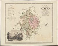
- Published / Created:
- 1830
- Call Number:
- 3224 1830
- Container / Volume:
- BRBL_00060
- Image Count:
- 1
- Resource Type:
- Maps, Atlases & Globes
- Description:
- Preliminary record. and View: Warwick Castle.
- Publisher:
- Greenwood & Co.,
- Subject (Geographic):
- Warwickshire (England)--Maps
- Found in:
- Beinecke Rare Book and Manuscript Library > Map of the County of Warwick ... By C. & J. Greenwood. Engraved by J. & C. Walker.
- Published / Created:
- 1830
- Call Number:
- 3253 1830
- Container / Volume:
- BRBL_00067
- Image Count:
- 1
- Resource Type:
- Maps, Atlases & Globes
- Description:
- Preliminary record. and View of Appleby.
- Publisher:
- Greenwood & Co.,
- Subject (Geographic):
- Westmorland (England)--Maps
- Found in:
- Beinecke Rare Book and Manuscript Library > Map of the County of Westmorland ... by C. & J. Greenwood. Engraved by J. & C. Walker.
- Published / Created:
- 1829
- Call Number:
- 3223 1829
- Container / Volume:
- BRBL_00060
- Image Count:
- 1
- Resource Type:
- Maps, Atlases & Globes
- Description:
- Preliminary record. and View: Salisbury Cathedral.
- Publisher:
- Greenwood & Co.,
- Subject (Geographic):
- Wiltshire (England)--Maps
- Found in:
- Beinecke Rare Book and Manuscript Library > Map of the County of Wilts ... By C. & J. Greenwood. Engraved by J. & C. Walker.
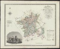
- Published / Created:
- 1830
- Call Number:
- 3254 1830
- Container / Volume:
- BRBL_00068
- Image Count:
- 1
- Resource Type:
- Maps, Atlases & Globes
- Description:
- Preliminary record. and View: Worcester Cathedral.
- Publisher:
- Greenwood & Co.,
- Subject (Geographic):
- Worcestershire (England)--Maps
- Found in:
- Beinecke Rare Book and Manuscript Library > Map of the County of Worcester ... by C. & J. Greenwood. Engraved by J. & C. Walker.
- Creator:
- Wilkes, Charles, 1798-1877
- Published / Created:
- 1858
- Call Number:
- 785 D36 1858
- Container / Volume:
- BRBL_00513
- Image Count:
- 1
- Resource Type:
- Maps, Atlases & Globes
- Description:
- Taken from: Report on the examination of the Deep River district, North Carolina, by Charles Wilkes.
- Publisher:
- C.B. Graham,
- Subject (Geographic):
- North Carolina--Maps
- Subject (Name):
- Wilkes, Charles, 1798-1877. Report on the examination of the Deep River district, North Carolina
- Found in:
- Beinecke Rare Book and Manuscript Library > Map of the Deep River District, North Carolina / by Capt. C. Wilkes, U.S.N.