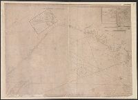
Imperfect: all sheets but southeast sheet wanting. Manuscript title on verso, "Sault Ste. Marie to Lake Nipissing." From the Richard H. Rickard Papers. and Title devised by cataloger; description based on imperfect copy.
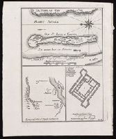
[Top] Chart of the island of Saint Louis showing location of the Fort St. Louis, the reservoir, and dwellings in western Africa; [bottom left] Chart of the location of Fort St. Joseph in Bakel, Senegal, on the Senegal River; [bottom right] Plan of the Fort St. Joseph.
Alternative Title:
Egnen fra fortet St. Joseph til Galam and Grundridsning of fortet St. Joseph
Description:
"No. 14" in upper right corner; "III.D." in lower right corner., Coordinates not present on map and are approximated., From Almindelig histoirie over reiser til lands og bands ... (Kjøbenhavn: Niels Hansen Møller, 1749), a translation of Collection of voyages and travels edited by Awnsham Chruchill and Thomas Osborne., North oriented towards the left on first map., Relief shown pictorially., and Title of first map devised by cataloger.
Publisher:
[Niels Hansen Møller],
Subject (Geographic):
Bakel (Senegal : Department)--Maps--Early works to 1800. and Saint-Louis (Senegal)--Maps--Early works to 1800.
Subject (Name):
Churchill, Awnsham, -1728. Collection of voyages and travels. Danish., Møller, Niels Hansen, and Osborne, Thomas, -1767. Collection of voyages and travels. Danish.