Dorn, Sebastian Hase, Johann Matthias, 1684-1742 Homann Erben (Firm)
Published / Created:
1744
Call Number:
1973 Folio 30
Collection Title:
[Atlas factice of 32 maps and 1 distance table, produced by the Homann Erben firm]
Image Count:
2
Alternative Title:
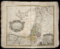
Carte d’Hongrie en general, contenant selon la division ancienne & methodique, la Hongrie, en particulier, la Croatie, la Dalmatie, la Bosnie, la Servie, la Boulgarie, la Principaute de Transylvanie, les Despotats de Walachie & de Moldav and Hungariae ampliori significatu et veteris vel methodicae, complexae regna: Hungariae Propriae, Crotiae, Dalmatiae, Bosniae, Serviae, Cumaniae, principatum: Transylvaniae, despotus: Walachiae, Moldaviae (exclusis ab eadem alienatis Galitia et Ludmomiria) in suas provincias ac partes divisae et quoad Imperantes ex Austriacis, Turcis et Venetis distinctae (juncta tamen propter commidatem Romania vel Romelia Turcica) tabula
Publisher:
Curantibus Homannianis Heredibus
Subject (Geographic):
Balkan Peninsula --Maps --Early works to 1800 and Hungary --Maps --Early works to 1800
Homann Erben (Firm) Homann, Johann Baptist, 1663-1724
Published / Created:
[1746?]
Call Number:
1973 Folio 30
Collection Title:
[Atlas factice of 32 maps and 1 distance table, produced by the Homann Erben firm]
Image Count:
2
Alternative Title:
Allemagne distinguee en ses cercles & subdivisee en ses etats, contenant son etendue presente rectifiee & methodiquement enluminee suivant les elements de geographie de Mr. Schatz and Imperii Romano Germanici in suos status et circulos divisi tabula generalis
Publisher:
[Homann Erben?]
Subject (Geographic):
Austria --Maps --Early works to 1800, Czechoslovakia --Maps --Early works to 1800, Germany --Maps --Early works to 1800, Hungary --Maps --Early works to 1800, and Poland --Maps --Early works to 1800
Homann Erben (Firm) Homann, Johann Baptist, 1663-1724
Published / Created:
ca. 1741
Call Number:
1975 Folio 31
Collection Title:
[Atlas factice of 42 maps, produced by the Homann Erben firm]
Image Count:
2
Alternative Title:
Allemagne distinguee en ses cercles & subdivisee en ses etats, contenant son etendue presente rectifiee & methodiquement enluminee suivant les elements de geographie de Mr. Schatz a 1741 avec privilege imperial and Imperii Romano Germanici in suos status et circulos divisi tabula generalis
Publisher:
Homann Erben?
Subject (Geographic):
Austria --Maps --Early works to 1800, Czechoslovakia --Maps --Early works to 1800, Germany --Maps --Early works to 1800, Hungary --Maps --Early works to 1800, and Poland --Maps --Early works to 1800
[Atlas factice of 32 maps and 1 distance table, produced by the Homann Erben firm]
Image Count:
2
Alternative Title:
Carte des etats de la Covronne de Pologne
Publisher:
Luci publicae tradita per Homannianos Heredes
Subject (Geographic):
Belarus --Maps --Early works to 1800, Lithuania --Maps --Early works to 1800, Poland --Maps --Early works to 1800, and Ukraine --Maps --Early works to 1800
Hase, Johann Matthias, 1684-1742 Homann Erben (Firm) Lowitz, G. M. (George Moritz), 1722-1774
Published / Created:
1746
Call Number:
1975 Folio 31
Collection Title:
[Atlas factice of 42 maps, produced by the Homann Erben firm]
Image Count:
1
Alternative Title:
Mappe-monde qui represente les deux hemispheres savoir celui de l’orient et celui de l’occident, tiree des quatre cartes generales de feu M. le profess. Hasius, dressee par Mr. G.M. Lowitz et publiee par les Heritiers de Homann, avec privil. imper and Planiglobii terrestris mappa vniversalis
Publisher:
Homann Erben
Subject (Topic):
Atlases, German --Early works to 1800, Religion --Maps --Early works to 1800, and World maps --Early works to 1800
Hase, Johann Matthias, 1684-1742 Homann Erben (Firm) Lowitz, G. M. (George Moritz), 1722-1774
Published / Created:
1746
Call Number:
1973 Folio 30
Collection Title:
[Atlas factice of 32 maps and 1 distance table, produced by the Homann Erben firm]
Image Count:
1
Alternative Title:
Mappe-monde qui represente les deux hemispheres savoir celui de l’orient et celui de l’occident, tiree des quatre cartes generales de feu M. le profess. Hasius, dressee par Mr. G.M. Lowitz et publiee par les Heritiers de Homann and Planiglobii terrestris mappa vniversalis
Description:
Map colored to show distribution of religions.
Publisher:
[Homann Erben]
Subject (Topic):
Atlases, German --Early works to 1800, Religion --Maps --Early works to 1800, and World maps --Early works to 1800
[Atlas factice of 42 maps, produced by the Homann Erben firm]
Image Count:
1
Alternative Title:
Praefectura Generalis et Comitatus Provinciae
Subject (Geographic):
Alpes de Haute-Provence (France) --Maps --Early works to 1800, Alpes-Maritimes (France) --Maps --Early works to 1800, Bouches-du-Rhone (France) --Maps --Early works to 1800, France, Southern --Maps --Early works to 1800, Var (France) --Maps --Early works to 1800, and Vaucluse (France : Dept.) --Maps --Early works to 1800