Skip to search
Skip to main content
Skip to first result
Search
You Searched For
Format
cartographic
Language
French
New Search
Search Results
Published / Created:
[1750]
Call Number:
655gmg 1750
Container / Volume:
BRBL_00708
Image Count:
1
Resource Type:
Maps, Atlases & Globes
Description:
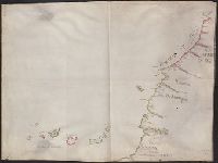
Color: plum, green and some blue. and Roiaume de Fez. Roiaume de Maroque, Zahara, and les Illes de Canarie, 1750.
Subject (Geographic):
Africa, West--Maps, Manuscript--Early works to 1800
Found in:
Beinecke Rare Book and Manuscript Library > [Manuscript map of the coastline of Western Africa].
Published / Created:
[1800?]
Call Number:
18 1800
Container / Volume:
BRBL_00012
Image Count:
6
Resource Type:
Maps, Atlases & Globes
Description:
12 sheets missing. and Sheets 1, Isles George; 2. Découvertes boreales; 3. Baie de Baffin; 10. Detroit de Davis; 17. Ile Southampton; 18. Detroit de Hudson.
Subject (Geographic):
Arctic Regions--Maps--Early works to 1800
Found in:
Beinecke Rare Book and Manuscript Library > [Map of Arctic Regions in 18 sheets].
Call Number:
Zc20 758Le
Collection Title:
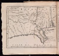
Histoire de la Louisiane : contenant la decouverte de ce vaste pays ; sa description geographique
Image Count:
1
Subject (Geographic):
Louisiana --Description and travel, Louisiana --History --To 1803, Louisiana --Maps --Early works to 1800, Mexico, Gulf of --Discovery and exploration --French, and Mexico, Gulf of --Maps --Early works to 1800
Subject (Topic):
Indians of North America --Mississippi River Valley and Natural history --Louisiana
Collection Created:
Paris : De Bure, l'aine [etc.], 1758
Found in:
Beinecke Rare Book and Manuscript Library > [Map of Louisiana]
Published / Created:
1618?
Call Number:
Taylor 278
Collection Title:
Jovrnal ou Description dv merveillevx voyage de Gvillavme Schovten, hollandois natif de Hoorn
Image Count:
1
Description:
Bound in facing p. 72., Imperfect: Map wormed, with loss of text; repair made on back of map., and Scale not given.
Subject (Geographic):
New Guinea --Maps --Early works to 1800
Subject (Name):
Schouten, Willem Corneliszoon, d. 1625
Collection Created:
A Amstredam : Chez Harman Ianson, marchand libraire, demeurant en la VVarmoes-straet, a le Sereine, 1619
Found in:
Beinecke Rare Book and Manuscript Library > [Map of Nova Guinea]
Published / Created:
1918
Call Number:
11hc 1918-Z4
Container / Volume:
BRBL_00010H
Image Count:
1
Resource Type:
Maps, Atlases & Globes
Description:
"Bearbeitet und gedruckt im Juli 1918.", "Zusammendruck A" at head of map., and French and German.
Publisher:
s.n.,
Subject (Geographic):
France--Maps
Found in:
Beinecke Rare Book and Manuscript Library > [Map of area around Château-Thierry, France.]
Published / Created:
[1725?]
Call Number:
40 1725
Container / Volume:
BRBL_00197
Image Count:
2
Resource Type:
Maps, Atlases & Globes
Description:
Verso: Shows greater part of Italy with Corsica and Sardinia, etc.
Subject (Geographic):
Italy--Maps--Early works to 1800
Found in:
Beinecke Rare Book and Manuscript Library > [Map of southern Italy to Africa and adjacent regions].
Published / Created:
[1918?]
Call Number:
11hc 1918Y
Container / Volume:
BRBL_00010F
Image Count:
2
Resource Type:
Maps, Atlases & Globes
Alternative Title:
Gratuitement : and Le Journal offre gratuitement ce Supplément á tous ses Lecteurs
Description:
Title Supplied by cataloger. and Verso: Photographs of political and military leaders.
Publisher:
Le Journal,
Subject (Geographic):
Belgium--Maps, France--Maps, and Luxembourg--Maps
Subject (Topic):
World War, 1914-1918--Belgium--Maps, World War, 1914-1918--France--Maps, and World War, 1914-1918--Luxembourg--Maps
Found in:
Beinecke Rare Book and Manuscript Library > [Map of the Western Front].
Published / Created:
[1685?]
Call Number:
11 1685
Container / Volume:
BRBL_00003
Image Count:
1
Resource Type:
Maps, Atlases & Globes
Description:
In french with long explanation of the use of letters in the margin for finding places mentioned in tables above and below map. Last date mentioned is 1685. and Preliminary record.
Subject (Geographic):
World--Maps--Early works to 1800
Found in:
Beinecke Rare Book and Manuscript Library > [Map of the World in Two Hempispheres].
Published / Created:
191-.
Call Number:
11hc 1918-Z2
Container / Volume:
BRBL_00010G
Image Count:
2
Resource Type:
Maps, Atlases & Globes
Publisher:
s.n.,
Subject (Geographic):
France--Maps
Found in:
Beinecke Rare Book and Manuscript Library > [Map showing area surrounding Coucy, France.]
Published / Created:
[1740?]
Call Number:
38 P21 1740
Container / Volume:
BRBL_00160
Image Count:
1
Resource Type:
Maps, Atlases & Globes
Subject (Geographic):
Paris (France)--Maps--Early works to 1800
Found in:
Beinecke Rare Book and Manuscript Library > [Paris and Environs].
Branch:v1.61.6 ,Deployed:2024-06-12T09:55:31-04:00