Panorama de l'Afrique françaises and Petit journal. Supplément illustré.
Description:
From Supplément illustré du Le Petit journal (pages 79-80; 1894?)., Includes insert maps "Environs de Tombouctou" and "Plan de Tombouctou.", and Relief shown by hachures.
Subject (Geographic):
Africa, North--Maps, Africa, West--Maps, Africa--Discovery and exploration--French--Maps, France--Colonies--Africa--Maps, and Tombouctou (Mali)--Maps
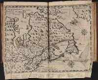
Les voyages dv sievr de Champlain Xaintongeois, capitaine ordinaire pour le Roy, en la marine
Image Count:
1
Description:
Between p. 160-161.
Subject (Geographic):
New France --Discovery and exploration and New France --Maps --Early works to 1800
Subject (Name):
Pelletier, David
Subject (Topic):
Indians of North America --Canada
Collection Created:
A Paris : Chez Iean Berjon, rue S. Iean de Beauuais, au Cheual volant, & en sa boutique au Palais, a la gallerie des prisonniers, MDCXIII [1613]. Avec privilege dv Roy
"Avec privilège"., Hand colored, Relief shown pictorially., and Stamp: Karpinski-von Wieser Map Collection. "99"; "Allard"--Manuscript notes.
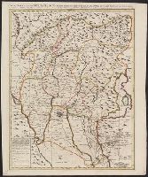
Subject (Geographic):
Padua (Italy : Province)--Maps--Early works to 1800, Rovigo (Italy : Province)--Maps--Early works to 1800, and Venice (Italy)--Maps--Early works to 1800
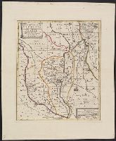
Anville, Jean Baptiste Bourguignon d', 1697-1782, cartographer
Call Number:
655 1751
Container / Volume:
BRBL_00345
Image Count:
1
Resource Type:
Maps, Atlases & Globes
Description:
Bar scales given in "Lieues Françoises de 3000 Pas Géométriques ou de 2500 Toises" and "Lieues Marines de 20au Degré, ou d'environ 2850 Toises.", Prime meridian: Ferro., Relief sho, Shows anchorages, banks, rivers, settlements, kingdoms, etc., and Watermarks.
Subject (Geographic):
Africa, West--Maps--Early works to 1800
Subject (Name):
Anville, Jean Baptiste Bourguignon d', 1697-1782. Atlas général and Haye, G. de la, engraver