Skip to search
Skip to main content
Skip to first result
Search
You Searched For
Format
cartographic
Language
German
New Search
Search Results
Creator:
Published / Created:
ca. 1757
Call Number:
1973 Folio 30
Collection Title:
[Atlas factice of 32 maps and 1 distance table, produced by the Homann Erben firm]
Image Count:
2
Publisher:
[Tobias Conrad Lotter]
Subject (Geographic):
Saxony (Germany) --Maps --Early works to 1800
Subject (Topic):
Atlases, German --Early works to 1800
Collection Created:
[Nuremberg : s.n., 1701-1760]
Found in:
Beinecke Rare Book and Manuscript Library > Electoratus Saxonici Praefecturae Annaburgensis, Pretzschens[is] Torgaviensis, Schweinicensis, Muehlbergensis studio geographico / [cartographic material] / ita depictae, ut urbes, oppida, vici, pagi, aedes solitar cum vicinia accurate distingui possint a
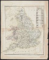
Creator:
Published / Created:
1588?]
Call Number:
319 1588
Container / Volume:
BRBL_00039
Image Count:
2
Resource Type:
Maps, Atlases & Globes
Alternative Title:
Engellandt die Insel wie sie zu unsern zeiten is beschriben mit den anstossenden Ländern Schottlandt und Irlandt
Description:
Appears in Münster's Cosmographia. 1588., Covers Great Britain and eastern Ireland., Includes text and ill., Oriented with north to the right., Other title on verso., Relief shown pictorially., and Signature mark on verso: iiii.
Publisher:
S. Petri,
Subject (Geographic):
British Isles--Maps--Early works to 1800
Found in:
Beinecke Rare Book and Manuscript Library > Engellandt mit dem anstossenden Reich Schottlandt, so vorzeiten Albion und Britannia haben geheissen.
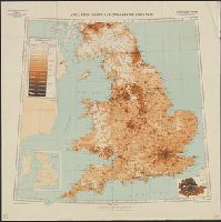
Creator:
Published / Created:
1940
Call Number:
32eb 1940
Container / Volume:
BRBL_00075
Image Count:
1
Resource Type:
Maps, Atlases & Globes
Description:
Based on Ordnance Survey map of 1934, from 1931 census., Includes insets of London County, and county boundaries., Population density shown by layer coloring., and Relief shown by spot heights.
Publisher:
Generalstab des Heeres, Abteilung für Kriegskarten- und Vermessungswesen (Mil.-Geo.),
Subject (Geographic):
England--Population--Maps
Subject (Topic):
Population density--England--Maps
Found in:
Beinecke Rare Book and Manuscript Library > England : Bevölkerungsverteilung 1931.
Published / Created:
[1845?]
Call Number:
32 1845A
Container / Volume:
BRBL_00045
Image Count:
1
Resource Type:
Maps, Atlases & Globes
Description:
Platt's grosser Atlas der Erde No. 41. and Preliminary record.
Subject (Geographic):
England--Maps
Found in:
Beinecke Rare Book and Manuscript Library > England und das Fürstenshum Wales. Lith ... Albr. Platt.
Published / Created:
[1940?]
Call Number:
319 1940
Container / Volume:
BRBL_00040
Image Count:
2
Resource Type:
Maps, Atlases & Globes
Description:
Verso: Countries around the North Sea, World showing colonies etc.
Publisher:
Georg Westermann,
Subject (Geographic):
British Isles--Maps
Found in:
Beinecke Rare Book and Manuscript Library > England. Mit Genehmigung de Bibliographischen Instituts in Leipzig.
Published / Created:
1791
Call Number:
739 1791
Container / Volume:
BRBL_00388
Image Count:
1
Resource Type:
Maps, Atlases & Globes
Publisher:
Gestochen von Carl Jäck,
Subject (Geographic):
British Columbia--Maps--Early works to 1800
Found in:
Beinecke Rare Book and Manuscript Library > Entwurf der neuesten Entdeckungen an der Nordwestküste von America (nach Hanna, Johnstone, Wedgborough, Portlock, Dixon, Duncan, Meares und de la Quadra,) von Georg Forster.
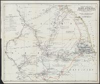
Creator:
Published / Created:
1861
Call Number:
63 1861
Container / Volume:
BRBL_00334
Image Count:
1
Resource Type:
Maps, Atlases & Globes
Alternative Title:
Ost-Afrika zwischen Chartúm & dem Rothen Meere
Description:
Includes text., Prime meridians: Paris and Greenwich., and Relief shown by hachures.
Publisher:
Justus Perthes,
Subject (Geographic):
Eritrea--Discovery and exploration--Maps, Ethiopia--Discovery and exploration--Maps, and Sudan--Discovery and exploration--Maps
Subject (Name):
Heuglin, Theodor von,--1824-1876 and Justus Perthes (Firm : Gotha, Germany)
Found in:
Beinecke Rare Book and Manuscript Library > Entwurf einer Karte von Ost-Afrika zwischen Chartúm & dem Rothen Meere, bis Sauakin und Massaua : nach allen vorhandenen Quellen entworfen von A. Petermann, zum Gebrauch der v. Heuglin'schen Expedition ausgeführt durch Justus Perthes' Geographisches Ans
Creator:
Published / Created:
[ca. 1758]
Call Number:
1973 Folio 30
Collection Title:
[Atlas factice of 32 maps and 1 distance table, produced by the Homann Erben firm]
Image Count:
2
Publisher:
Anjezo im Verlag bey Tobias Conrad Lotter, Geogr. ...
Subject (Geographic):
Saxony-Anhalt (Germany) --Maps --Early works to 1800
Subject (Topic):
Atlases, German --Early works to 1800
Collection Created:
[Nuremberg : s.n., 1701-1760]
Found in:
Beinecke Rare Book and Manuscript Library > Episcopatus Numburgensis et cizensis delineatio geographica adjectis praefecturis Portensi, Pegaviensi, Tautenburg et finitimis / [cartographic material] / cura Matth. Seutteri Geogr. Caes
Published / Created:
1740
Call Number:
36 Er37 1740
Container / Volume:
BRBL_00123
Image Count:
1
Resource Type:
Maps, Atlases & Globes
Description:
Beautifully detailed and decorated map., Index., and Inset: View of Erfurt.
Publisher:
Mathaeus Seutter,
Subject (Geographic):
Germany--Maps--Early works to 1800
Found in:
Beinecke Rare Book and Manuscript Library > Erfurt. Die Hoch Berühmt und Grosseste Haupt Stadt Thüringens, nach der neuest und accuratesten Zeichnung verfertigt ... Defignafione Erhardi Georgii Koenig.
Published / Created:
1879
Call Number:
11 1509
Container / Volume:
BRBL_00002
Image Count:
1
Resource Type:
Maps, Atlases & Globes
Description:
Facsimile.
Subject (Geographic):
World--Maps--Early works to 1800
Found in:
Beinecke Rare Book and Manuscript Library > Erster gedruckter Globus. Martin Hylacomylus (Waltzemüller). Gehört Warhscheinlich zu seinem 1509 herausgegeben Buche Globus Munde.
Branch:v1.61.6 ,Deployed:2024-06-12T09:55:33-04:00