Search
You Searched For
Search Results
- Published / Created:
- [1650]
- Call Number:
- 11 1650B
- Container / Volume:
- BRBL_00003
- Image Count:
- 2
- Resource Type:
- Maps, Atlases & Globes
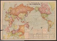
- Description:
- Japanese map showing 6 most important areas: Asia, China, North and South America, Africa and Europe and Micronesia.
- Subject (Geographic):
- World--Maps--Early works to 1800
- Found in:
- Beinecke Rare Book and Manuscript Library > Map of the World.
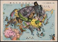
- Creator:
- Tanaka, Ryōzō
- Published / Created:
- [1914?]
- Call Number:
- 13am 1914
- Container / Volume:
- BRBL_00011
- Image Count:
- 1
- Resource Type:
- Maps, Atlases & Globes
- Alternative Title:
- Illustration of the Great European War.
- Description:
- "A humoros atlas of the world."
- Subject (Geographic):
- Eastern Hemisphere--Maps
- Subject (Topic):
- World War, 1914-1918--Maps
- Found in:
- Beinecke Rare Book and Manuscript Library > The illustration of the Graet European War. No. 16.
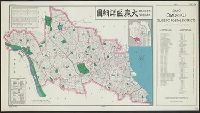
- Creator:
- United States. Office of Strategic Services. Research and Analysis Branch
- Published / Created:
- 1945
- Call Number:
- 57 T578 1945A
- Container / Volume:
- BRBL_00304
- Image Count:
- 1
- Resource Type:
- Maps, Atlases & Globes
- Alternative Title:
- Ōmori-ku shōsaizu, Tōkyō, Ōmori-ku, guide to postal districts [cartographic material] = 大森區詳細圖., and 大森區詳細圖
- Description:
- "No. 34."
- Publisher:
- Reproduction Branch, OSS,
- Subject (Name):
- United States. Office of Strategic Services. Reproduction Branch
- Subject (Topic):
- Postal service--Japan--Tokyo--Maps
- Found in:
- Beinecke Rare Book and Manuscript Library > Tōkyō, Ōmori-ku, guide to postal districts = Ōmori-ku shōsaizu.