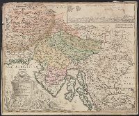
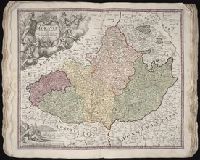
Bar scales given in "milliaria Germanica" and "milliaria Italica.", Insets: map of Cirkhnitzer See and bird's-eye view "Prospekt der St. Laybach ...", Relief shown pictorially., Sheet measures 49.6 x 58.8 cm., and Title in Latin; insets in German.
Publisher:
[Johann Baptist Homann,
Subject (Geographic):
Carniola (Slovenia)--Maps--Early works to 1800 and Croatia--Maps--Early works to 1800
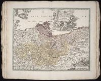
Terra neuf, en de custen van Nieu Vranckryck, Nieu Engeland, Nieu Nederland, Nieu Andalusia, Guiana en Venezuela
Description:
At upper right corner: Fol. 26., Covers the Atlantic Ocean west of, From Renard's Atlas de la navigation et du commerce ... Amsterdam : Chez Louis Renard, 1715., In Latin and Dutch., Includes two decorative cartouches and ill., and Oriented with north to the left.
Publisher:
Gedruckt by L. Renard,
Subject (Geographic):
North Atlantic Ocean--Maps--Early works to 1800
Subject (Name):
Renard, Louis. Atlas de la navigation et du commerce
Subject (Topic):
Nautical charts--North Atlantic Ocean--Early works to 1800