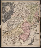
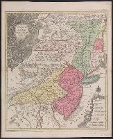
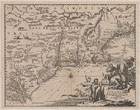
1st state. Cross collection no. 20. No. 3 of 3 maps mounted on linen., Appeared in Arnoldus Montanus's De Nieuwe en onbekende weereld., Includes ill., and Relief shown pictorially.
Publisher:
Jacob von Meurs?,
Subject (Geographic):
NewEngland--Maps--Early works to 1800
Subject (Name):
Montanus, Arnoldus, 1625?-1683. Nieuwe en onbekende weereld
Appeared in Arnoldus Montanus's De Nieuwe en onbekende weereld., Copy 2: 1st state. Uncolored. Mounted on linen. Dimensions: 29 x 37 cm., on sheet 36 x 44 cm. Verso: Stamped "Yale"., Includes ill., and Relief shown pictorially.
Publisher:
Jacob von Meurs?,
Subject (Geographic):
NewEngland--Maps--Early works to 1800
Subject (Name):
Montanus, Arnoldus, 1625?-1683. Nieuwe en onbekende weereld
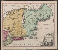
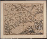
Appears in the author's Descriptionis Ptolemaicae augmentum. 1597., Covers the Atlantic coast of North America from Nova Scotia to Virginia., Has watermark., In upper right: 17., and Relief shown pictorially.
Publisher:
J. Bogard],
Subject (Geographic):
Atlantic Coast (U.S.)--Maps--Early works to 1800
Subject (Name):
Bogard, Jean, d. ca. 1634 and Wytfliet, Corneille. Descriptionis Ptolemaicae augmentum
Subject (Topic):
Coasts--Maritime Provinces--Maps--Early works to 1800
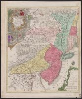
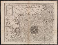
Appears in various eds. of Atlas geographicus maior., Includes German text relating to English and French territorial claims., Neat lines measures 45.8 x 50.8 cm. on sheet 50 x 57.5 cm. Ms. note on verso: No. 151, Nord America nach d'Anville. Franklin Collection no. 131 1756-9., Place names and descriptive notes in English., Prime meridian: Ferro and London., and Relief shown pictorially.
Publisher:
[Homann Erben],
Subject (Geographic):
North America--Maps--Early works to 1800 and United States--History--French and Indian War, 1755-1763--Maps--Early works to 1800
Subject (Name):
Anville, Jean Baptiste Bourguignon d', 1697-1782 and Homann Erben (Firm). Atlas geographicus maior