Search
You Searched For
Search Results
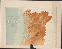
- Creator:
- Comissão do Serviço Geológico de Portugal
- Published / Created:
- [1906]
- Call Number:
- 397cbf 1906
- Container / Volume:
- BRBL_00195
- Image Count:
- 2
- Resource Type:
- Maps, Atlases & Globes
- Found in:
- Beinecke Rare Book and Manuscript Library > Carta hypsometrica de Portugal [cartographic material] : 1906.
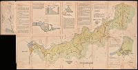
- Creator:
- Portugal. Ministério do Ultramar. Inspecção-geral do fomento
- Published / Created:
- [1954]
- Call Number:
- BrSides Double Folio 2019 8
- Image Count:
- 2
- Resource Type:
- Maps, Atlases & Globes
- Found in:
- Beinecke Rare Book and Manuscript Library > Aproveitamentos do Cunene, 20 VI 54.
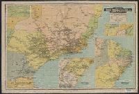
- Creator:
- Guía Levi (Firm)
- Published / Created:
- 1926
- Call Number:
- 911 1926
- Container / Volume:
- BRBL_00669
- Image Count:
- 2
- Resource Type:
- Maps, Atlases & Globes
- Found in:
- Beinecke Rare Book and Manuscript Library > Mappa da viação ferrea dos E.U. do Brasil e da Rep. do Uruguay [cartographic material] / organizado expressamente para o Guía Levi.
- Creator:
- Cavalcanti, Manoel Paulino
- Published / Created:
- [1913?]
- Call Number:
- 911g 1913
- Container / Volume:
- BRBL_00672
- Image Count:
- 2
- Resource Type:
- Maps, Atlases & Globes
- Found in:
- Beinecke Rare Book and Manuscript Library > Mappa económico do Brazil [cartographic material] / Serviço da Informações, Ministério de Agricultura, Indústria e Commércio ; organizado por M. Paulino Cavalcanti.
- Creator:
- Fernandes, José, Cartographer, cartographer.
- Call Number:
- Manuscript 911cea 1789
- Image Count:
- 2
- Resource Type:
- Maps, Atlases & Globes
- Found in:
- Beinecke Rare Book and Manuscript Library > Carta reduzida de hua parte de costa do Brasil : desde o Morro de S. Paulo athê Santos / por José Fernandes, Portugal na Bahia de Todos os Santos no Anno de 1789.
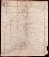
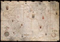
- Creator:
- Albernaz, João Teixeira, active 1665-1681
- Published / Created:
- [1665]
- Call Number:
- 11 1665
- Image Count:
- 2
- Resource Type:
- Maps, Atlases & Globes
- Found in:
- Beinecke Rare Book and Manuscript Library > Portolan chart of the Atlantic, the western half of the Indian Ocean, and the extreme southeast of the Pacific.
- Published / Created:
- ca. 1880]
- Call Number:
- 30 1880A
- Container / Volume:
- BRBL_00032
- Image Count:
- 1
- Resource Type:
- Maps, Atlases & Globes
- Found in:
- Beinecke Rare Book and Manuscript Library > A Europa em 1877 : mappa burlesco da guerra / por Abdul-Azis ; Livrarie Ferreira, editora ... ; Lith. Palhares ...
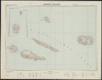
- Creator:
- Germany. Heer. Abteilung für Kriegskarten- und Vermessungswesen
- Published / Created:
- [1942]
- Call Number:
- 212 1942A
- Container / Volume:
- BRBL_00014
- Image Count:
- 1
- Resource Type:
- Maps, Atlases & Globes
- Found in:
- Beinecke Rare Book and Manuscript Library > Atlantische Inseln 1:200 000. [Azores] / bearbeitet und herausgegeben von der Heeresplankammer.
- Creator:
- Linschoten, Jan Huygen van, 1563-1611
- Published / Created:
- 1596?]
- Call Number:
- 63 1596
- Container / Volume:
- BRBL_00334
- Image Count:
- 1
- Resource Type:
- Maps, Atlases & Globes
- Found in:
- Beinecke Rare Book and Manuscript Library > Delineatio orarum maritimarum, terrae vulgo indigetatae terra do Natal item Sofalae, Mozambicae & Melindae ... [cartographic material] = Affbeeldinghe der custen des landts genaempt terra do Natal, item van alle de custen van Coffala, Mozambique, Melinde