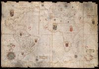
"Feita por João Teix[ei]ra Albernass Cosmographo los Reinos de Portugal por Sua Mag[esta]de. O anno de 1665. L[i]x[bo]a", Contains five compass roses., Decoration: coats of arms in territories., Imperfect: chipped along edges., Manuscript annotations on verso., Pen-and-ink in black, red, blue, yellow and green., Portolan chart with seaport names given for all coastlines., and Title devised by cataloger.
Subject (Geographic):
Atlantic Ocean--Maps--Early works to 1800., Indian Ocean--Maps--Early works to 1800., and Pacific Ocean--Maps--Early works to 1800.
Subject (Topic):
Nautical charts--Atlantic Ocean--Early works to 1800., Nautical charts--Indian Ocean--Early works to 1800., and Nautical charts--Pacific Ocean--Early works to 1800.
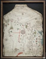
Contains seven compass roses., Decoration: armorial shields and city views with banners., In frame 88 x 115 cm., Pen-and-ink in brown, red, and green., Portolan chart with seaport names given for all coastlines., and Title devised by cataloger.
Subject (Geographic):
Black Sea--Maps--Early works to 1800., Mediterranean Sea--Maps--Early works to 1800., and North Atlantic Ocean--Maps--Early works to 1800.
Subject (Topic):
Nautical charts--Black Sea--Early works to 1800., Nautical charts--Mediterranean Sea--Early works to 1800., and Nautical charts--North Atlantic Ocean--Early works to 1800.
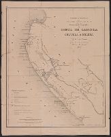
Descriptio ac delineatio geographica detectionis freti, sive, transitus ad occasum supra terras
Image Count:
1
Abstract:
Map depicts the Coat of Arms of the United Kingdom (era of the Union of the Crowns), reigning between the years 1603-1707.
Alternative Title:
Tabula nautica, qua repraesentantur orae maritimae, meatus, ac freta, noviter a H. Hudsono Anglo ad Caurum supra Novam Franciam
Description:
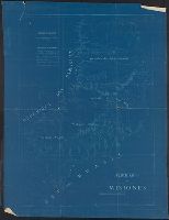
Bound in after p. [2]., In pencil on recto: 170., Map cut and folded irregularly., Map has multiple small stains on both the recto and verso., and Scale [ca. 1:9,000,000].
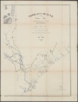
Descriptio ac delineatio geographica detectionis freti, sive, transitus ad occasum supra terras
Image Count:
1
Abstract:
Map depicts the Coat of Arms of the United Kingdom (era of the Union of the Crowns), reigning between the years 1603-1707.
Alternative Title:
Tabula nautica ...
Description:
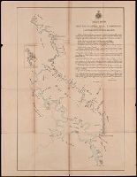
Bound in after p. [6]., In ink on recto: place names "Okkak", "Nain"[?] and one longer handwritten note on the bottom margin., Map cut and folded irregularly., Map has been repaired with multiple pieces of tape on verso., Map has multiple small stains on both the recto and verso., Printed on recto in lower right corner: A1., and Scale [ca. 1:9,000,000].
Subject (Geographic):
North Atlantic Ocean --Maps --Early works to 1800
Subject (Name):
Hudson, Henry, d. 1611
Collection Created:
Amsterodami Ex officina Hesse lij Gerardi. Anno 1613