Search
You Searched For
Search Results
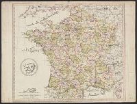
- Published / Created:
- [1795?]
- Call Number:
- 38 (1795)C
- Container / Volume:
- BRBL_00153
- Image Count:
- 1
- Resource Type:
- Maps, Atlases & Globes
- Subject (Geographic):
- France--Maps--Early works to 1800
- Found in:
- Beinecke Rare Book and Manuscript Library > Turkish Map of France.
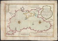
- Published / Created:
- 1723
- Call Number:
- 492 1723
- Container / Volume:
- BRBL_00270
- Image Count:
- 2
- Resource Type:
- Maps, Atlases & Globes
- Description:
- 4 sheets in 1., In Turkish., The first Turkish printed map., and Title supplied by cataloger.
- Publisher:
- Ibrahim Mutafarrikah,
- Subject (Geographic):
- Black Sea Coast--Maps--Early works to 1800 and Black Sea--Maps--Early works to 1800
- Found in:
- Beinecke Rare Book and Manuscript Library > [Engraved map of the coasts of the Black sea].
- Published / Created:
- [1729?]
- Call Number:
- 534 1729
- Container / Volume:
- BRBL_00289
- Image Count:
- 1
- Resource Type:
- Maps, Atlases & Globes
- Description:
- 4 sheets in 1., Preliminary record., and Title: "Mameluke Iran"
- Publisher:
- Ibrahim Mutafarrikah,
- Subject (Geographic):
- Iran--Maps--Early works to 1800
- Found in:
- Beinecke Rare Book and Manuscript Library > [Ibrahim Mutafarrikah's engraved map of the Persian Empire, showing also the Caucasus, southern Russia, Transcaucasian Turkestan, Iraq and part of Anatolia ... A.H. 1142 - A.D. 1729/30] [In Turkish].