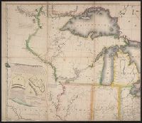
Subject: Map of the United States to the Mississippi River, and including parts of Upper and Lower Canada. Includes cartouche with a view of Niagara Falls and two Native Americans.
Description:
"Entered according to act of Congress October 1st, 1816 in the Dist. of Connecticut.", "Projected by Thomas Kensett.", "This view of the falls of Niagara is engraved from Tardieus map published at Paris. A. Doolittle sc.", and Dedicated to the president, senator
Publisher:
Shelton & Kensett,
Subject (Geographic):
Canada--Maps, Niagara Falls (N.Y. and Ont.)--Pictorial works, North America--Niagara Falls, and United States--Maps
Subject (Name):
Doolittle, Amos, 1754-1832, Kensett, Thomas, 1786-1829, and Shelton & Kensett
Subject (Topic):
Indians of North America and Indians of North America--Pictorial works
Les voyages de la Novvelle France occidentale, dicte Canada / faits par le Sr. de Champlain
Image Count:
1
Alternative Title:
Carte de la Nouuelle France.
Description:
Housed and classed separately as BrSides Folio 2008 15., In pencil on verso: Beinecke / Library / Broadsides / Folio / 2008 / 15 [(not digitized)]., Map formerly bound in facing p. 310 of Z6 14., Map formerly mounted on linen and folded., Scale [ca. 1:1,000,000]., and Teaching resource: Professor John Mack Faragher, History 141: The American West.
Subject (Geographic):
America--Discovery and exploration--French, Canada--Discovery and exploration, and Canada--Maps
Subject (Topic):
Indians of North America and Navigation--Early works to 1800
Collection Created:
A Paris : Chez Pierre LeMvr, dans la grand' salle du Palais, M.DC.XXXII. [1632]