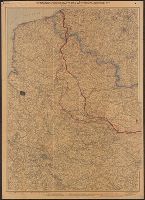
Carl Flemming (Firm) Flemming, C. (Carl), 1806-1878 Kettler, J. I
Published / Created:
[1918?]
Call Number:
11hc 1918P
Container / Volume:
BRBL_00010F
Image Count:
1
Resource Type:
Maps, Atlases & Globes
Description:
"Redigiert von Prof. Dr. J.I. Kettler"--Bottom left corner of Nordhälfte map., [1], [2], 11hc 1918P: Imperfect: First sheet (Nordhälfte) only., Nordhälfte (Paris und Umgebung bis zur Nordsee) --, Relief shown by shading., Sho, and Südhälfte (Reims bis Belfort).
Publisher:
Carl Flemming AG.,
Subject (Geographic):
Belgium--Maps, Europe--Maps, and France--Maps
Subject (Topic):
World War, 1914-1918--Belgium--Maps, World War, 1914-1918--Europe--Maps, and World War, 1914-1918--France--Maps
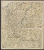
Laminated page 3 and 4 from The Times, dated Saturday, October 12, 1918. Text in English on verso.
Publisher:
The Times,
Subject (Geographic):
Belgium--Maps, France--Maps, Germany--Maps, and Luxembourg--Maps
Subject (Topic):
World War, 1914-1918--Belgium--Maps, World War, 1914-1918--France--Maps, World War, 1914-1918--Germany--Maps, and World War, 1914-1918--Luxembourg--Maps
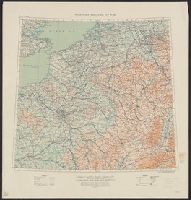
Enlarged scale map of territory between St. Quentin, La Fère and Laon, How to recognize the arms of the service., and Proper way to read military insignia.
Description:
"Supplement to Curtiss "Flyleaf," Curtiss Aeroplane and Motor Corporation, Buffalo, N.Y., U.S.A.", Inset: Enlarged scale map of territory between St. Quentin, La Fère and Laon. Scale [ca. 1:140,000]., On verso: How to recognize the, and Relief shown by shading.
Publisher:
Curtiss Aeroplane and Motor Corp.,
Subject (Geographic):
Belgium--Maps and France--Maps
Subject (Topic):
World War, 1914-1918--Belgium--Maps and World War, 1914-1918--France--Maps
Great Britain. War Office. General Staff. Geographical Section
Published / Created:
1915
Call Number:
11hc 1915E
Image Count:
1
Resource Type:
Maps, Atlases & Globes
Alternative Title:
Geographical Section General Staff ; 3024 and GSGS (Series) ; 3024.
Description:
Ms. notes outside bottom right margin: "Based on Paris M31, Frankfurt M32, Lyons L31 & Milan L32, of Europe 1:1,000,000.", Relief shown as contours and gradient tints., and Shows: international boundaries, relative importance of towns, railways (2 categories),
Publisher:
G.S.G.S.,
Subject (Geographic):
Belgium--Maps and France--Maps
Subject (Topic):
World War, 1914-1918--Belgium--Maps and World War, 1914-1918--France--Maps