Search
You Searched For
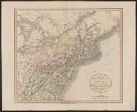
Search Results
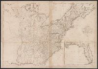
- Published / Created:
- 1809
- Call Number:
- 755 1809A
- Container / Volume:
- BRBL_00438
- Image Count:
- 1
- Resource Type:
- Maps, Atlases & Globes
- Found in:
- Beinecke Rare Book and Manuscript Library > A Map of the United States: compiled chiefly from the State Maps, and other Authentic Information, by Saml. Lewis.
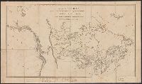
- Creator:
- Mackenzie, Alexander, 1764-1820
- Published / Created:
- 1801
- Call Number:
- 73 1801
- Container / Volume:
- BRBL_00374
- Image Count:
- 1
- Resource Type:
- Maps, Atlases & Globes
- Found in:
- Beinecke Rare Book and Manuscript Library > A map of America between latitudes 40 and 70 north and longitudes 45 and 180 west exhibiting Mackenzie's track from Montreal to Fort Chipewyan & from thence to the north sea in 1789 & to the west Pacific Ocean in 1793.
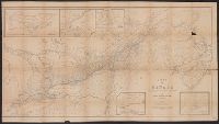
- Creator:
- Stavely, Edward
- Published / Created:
- [184-?]
- Call Number:
- 73 1849
- Container / Volume:
- BRBL_00374
- Image Count:
- 1
- Resource Type:
- Maps, Atlases & Globes
- Found in:
- Beinecke Rare Book and Manuscript Library > A map of Canada / compiled from the latest authorities by Edward Stavely ; engd. by W. & A.K. Johnston ....
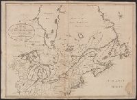
- Creator:
- Allen, F. D
- Published / Created:
- [1813]
- Call Number:
- 71 1813A
- Container / Volume:
- BRBL_00368
- Image Count:
- 1
- Resource Type:
- Maps, Atlases & Globes
- Found in:
- Beinecke Rare Book and Manuscript Library > A map of the British possessions in North America, including part of the United States / by F.D. Allen, 1815 ; J. Lewis sculpt.
- Creator:
- Shelton & Kensett
- Published / Created:
- [1816]
- Call Number:
- 75 1816
- Container / Volume:
- BRBL_00397
- Image Count:
- 4
- Resource Type:
- Maps, Atlases & Globes
- Found in:
- Beinecke Rare Book and Manuscript Library > A map of the United States and British provinces of Upper and Lower Canada with other parts adjacent [cartographic material] / by Shelton & Kensett.
- Published / Created:
- 1806
- Call Number:
- 755 1806
- Container / Volume:
- BRBL_00438
- Image Count:
- 1
- Resource Type:
- Maps, Atlases & Globes
- Found in:
- Beinecke Rare Book and Manuscript Library > A map of the United States and Canada, New Scotland, New Brunswick and Newfoundland. Dresée par Lapie ... Gravée par P.A.F. Tardieu. Ecrit par J.J. Pachoux.
- Creator:
- Morse, Jedidiah, 1761-1826
- Published / Created:
- 1797
- Call Number:
- GA405 +W44 (LC)
- Collection Title:
- Mapping the transmississippi West, 1540-1861
- Image Count:
- 1
- Found in:
- Beinecke Rare Book and Manuscript Library > A new map of North America shewing all the new discoveries [facsimile]
- Published / Created:
- 1806
- Call Number:
- 755 1806A
- Container / Volume:
- BRBL_00438
- Image Count:
- 1
- Resource Type:
- Maps, Atlases & Globes
- Found in:
- Beinecke Rare Book and Manuscript Library > A new map of part of the United States of North America ... by John Cary, Engraver.