"A Paris chez l'auteur ... avec privilege 25 Mai 1719.", "Avec privilege du 30 Av. 1745"., Relief shown pictorially., Shows forests, abbeys by religious order, priories, etc., and Watermark. Sheet measures 53 x 71 cm. Verso: "100" in manuscript.
Publisher:
Ph. Buache ...
Subject (Geographic):
Catholic Church.--Province of Tours (France)--Maps--Early works to 1800., Maine (France)--Maps--Early works to 1800., and Perche (France)--Maps--Early works to 1800.
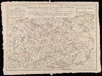
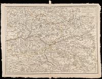
"Avec privilege du 30 Av. 1745"., Imprint below title: "A Paris, chez l'auteur ... 1712. 1. aout"., Prime meridian: Ferro., Relief shown pictorially., Shows abbeys by religious order, priories, pine and other forests, navigable rivers, etc., and Watermark. Sheet measures 53 x 71 cm. Verso: "108" in manuscript.
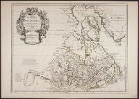
Appeared in L'Isle's Atlas géographique et universal., Includes descriptive text., Lower left: Ph. Buache ... Gendre de l'auteur, avec Privilege du 30 Au. 1745., Relief shown pictorially., and Sheet measures 54.7 x 76.5 cm. Ms. nos. on verso: 52.
Publisher:
Philippe Buache],
Subject (Geographic):
Canada--Maps--Early works to 1800 and New France--Maps--Early works to 1800
Subject (Name):
Buache, Philippe, 1700-1773 and L'Isle, Guillaume de, 1675-1726. Atlas géographique et universal
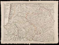
"Avec privilege du 30 Av. 1745"., Imprint in lower left: "A Paris chez l'auteur ... ", Prime meridian: Ferro., Relief shown pictorially., and Watermarks. Sheet measures 54 x 72 cm. Manuscript note on verso: 30.
Publisher:
Ph. Buache ...
Subject (Geographic):
Denmark--Maps--Early works to 1800., Schleswig-Holstein (Germany)--Maps--Early works to 1800., and Sweden--Maps--Early works to 1800.
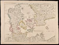
"Avec privilege du 30 Av. 1745"., Prime meridian: Ferro., Relief shown pictorially., Shows forests, etc., and Watermark. Sheet measures 53 x 70 cm. Verso: "101" in manuscript.
Publisher:
Ph. Buache ...
Subject (Geographic):
Anjou (France)--Maps--Early works to 1800. and Touraine (France)--Maps--Early works to 1800.
In lower right: Ph. Buache, P.G.d.R, d l'A.R.d.S. Gendre de l'auteur. Avec privilège du Roi., Library's copy stamped on backing: Yale University Library, Karpinski-Von Wieser Map Collection., and Relief shown pictorially.
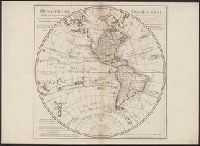
Publisher:
Dezauche,
Subject (Geographic):
America--Discovery and exploration--Maps and Western Hemisphere--Maps
Subject (Name):
Buache, Philippe, 1700-1773, Cook, James--(1728-1779)--Travel--Maps, and Dezauche, J
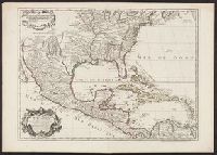
Backed with paper., From Gian Rinaldo Carli's Delle lettere americane (1780)., Map no.1 represents the shoals and sea floor between Africa and America; map no. 2 is a cross-section of the ocean floor between Africa and America; and map no. 3 is the eastern position of Asia and the western portion of America., and Relief shown by hachures.
Publisher:
[Gian Rinaldo Carli],
Subject (Geographic):
Atlantic Ocean--Maps--Early works to 1800. and Pacific Ocean--Maps--Early works to 1800.
Subject (Name):
Buache, Philippe, 1700-1773 and Carli, Gian Rinaldo, 1720-1795. Delle lettere americane.
Subject (Topic):
Oceanography--Charts, diagrams, etc.--Maps--Early works to 1800.