Skip to search
Skip to main content
Skip to first result
Search
You Searched For
Format
cartographic
Subject (Name)
Julius Bien & Co
Search Results
Creator:
Published / Created:
c1895.
Call Number:
771 Al52 1895
Container / Volume:
BRBL_00480
Image Count:
1
Resource Type:
Maps, Atlases & Globes
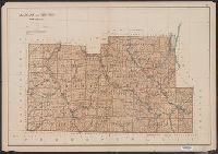
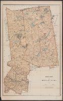
Description:
"Copyright 1895, Julius Bien & Company N.Y."
Publisher:
Julius Bien & Co.,
Subject (Geographic):
Allegany County (N.Y.)--Maps and Steuben County (N.Y.)--Maps
Subject (Name):
Bien, Joseph R. Atlas of the state of New York and Julius Bien & Co
Subject (Topic):
Land grants--New York (State)--Allegany County--Maps and Land grants--New York (State)--Steuben County--Maps
Found in:
Beinecke Rare Book and Manuscript Library > Allegany and Steuben counties.
Creator:
Published / Created:
1862
Call Number:
783hc 1862E
Container / Volume:
BRBL_00511
Image Count:
3
Resource Type:
Maps, Atlases & Globes
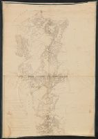
Description:
no. 1. Yorktown to Williamsburg -- no. 2. Williamsburg to White House -- no. 3. White House to Harrison's Landing.
Publisher:
Corps of Engineers?]
Subject (Geographic):
Virginia Peninsula (Va.)--Maps
Subject (Name):
Dougal, William H., 1822-1895, Humphreys, A. A. (Andrew Atkinson), 1810-1883, Julius Bien & Co, United States Coast Survey., and United States. Army of the Potomac
Subject (Topic):
Peninsular Campaign, 1862--Maps and Williamsburg, Battle of, Williamsburg, Va., 1862--Maps
Found in:
Beinecke Rare Book and Manuscript Library > Campaign maps, Army of the Potomac / prepared by command of Maj. Gen. George B. McClellan ; compilation under the direction of Brig. Gen. A.A. Humphreys, by Capt. H.L. Abbot ; engraved by W.H. Dougal ; Julius Bien & Co., photo lith.
Published / Created:
[1894?]
Call Number:
BrSides Double Folio 2018 93
Image Count:
1
Resource Type:
Maps, Atlases & Globes
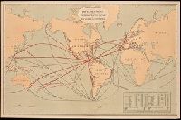
Description:
Includes "Table showing distances in miles between commercial ports of the world and distances saved by the Nicaragua Canal."
Publisher:
Julius Bein & Co., Photo. Lith.,
Subject (Geographic):
Nicaragua Canal (Nicaragua)--Maps. and Nicaragua--Nicaragua Canal
Subject (Name):
Julius Bien & Co
Subject (Topic):
Shipping--Maps
Found in:
Beinecke Rare Book and Manuscript Library > Chart of the world showing distances saved by the interoceanic canal of Nicaragua and Costa Rica [cartographic material].
Creator:
Published / Created:
c1895.
Call Number:
771 C39 1895
Container / Volume:
BRBL_00482
Image Count:
1
Resource Type:
Maps, Atlases & Globes
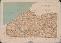
Description:
From: Atlas of the state of New York. New York : Julius Bien & Co., 1895.
Publisher:
Julius Bien & Co.,
Subject (Geographic):
Cattaraugus County (N.Y.)--Maps and Chautauqua County (N.Y.)--Maps
Subject (Name):
Bien, Joseph R. Atlas of the state of New York and Julius Bien & Co
Subject (Topic):
Land grants--New York (State)--Cattaraugus County--Maps and Land grants--New York (State)--Chautauqua County--Maps
Found in:
Beinecke Rare Book and Manuscript Library > Chautauqua and Cattaraugus counties.
Creator:
Published / Created:
c1895.
Call Number:
771 B863 1895
Container / Volume:
BRBL_00481
Image Count:
1
Resource Type:
Maps, Atlases & Globes
Description:
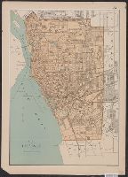
"Copyright 1895, Julius Bien & Company N.Y."
Publisher:
Julius Bien & Co.,
Subject (Geographic):
Buffalo (N.Y.)--Maps
Subject (Name):
Bien, Joseph R. Atlas of the state of New York and Julius Bien & Co
Found in:
Beinecke Rare Book and Manuscript Library > City of Buffalo.
Creator:
Published / Created:
c1895.
Call Number:
771 R582 1895
Container / Volume:
BRBL_00490
Image Count:
1
Resource Type:
Maps, Atlases & Globes
Description:
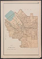
From: Atlas of the state of New York. New York : Julius Bien & Co., 1895.
Publisher:
Julius Bien & Co.,
Subject (Geographic):
Rochester (N.Y.)--Maps
Subject (Name):
Bien, Joseph R. Atlas of the state of New York and Julius Bien & Co
Found in:
Beinecke Rare Book and Manuscript Library > City of Rochester.
Creator:
Published / Created:
c1895.
Call Number:
771 S81 1895
Container / Volume:
BRBL_00491
Image Count:
1
Resource Type:
Maps, Atlases & Globes
Description:
From: Atlas of the state of New York. New York : Julius Bien & Co., 1895.
Publisher:
Julius Bien & Co.,
Subject (Geographic):
Syracuse (N.Y.)--Maps
Subject (Name):
Bien, Joseph R. Atlas of the state of New York and Julius Bien & Co
Found in:
Beinecke Rare Book and Manuscript Library > City of Syracuse.
Creator:
Published / Created:
1879
Call Number:
80cbj 1879
Container / Volume:
BRBL_00537
Image Count:
1
Resource Type:
Maps, Atlases & Globes
Description:
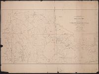
Relief shown by hachures and spot heights.
Publisher:
the Survey,
Subject (Geographic):
Green River Watershed (Wyo.-Utah)--Maps
Subject (Name):
Bechler, G. R, Chittenden, George B, Clark, Fred A, Gannett, Henry, 1846-1914, Hayden, F. V. (Ferdinand Vandeveer), 1829-1887, Julius Bien & Co, and Wilson, A. D. (Allen D.)
Subject (Topic):
Watersheds--Idaho--Maps, Watersheds--Utah--Maps, and Watersheds--Wyoming--Maps
Found in:
Beinecke Rare Book and Manuscript Library > Drainage map showing portions of Wyoming, Idaho and Utah / primary triangulation by A.D. Wilson ; topography by Henry Gannett, G.B. Chittenden, G.R. Bechler and F.A. Clark ; F.V. Hayden, U.S. Geologist in charge.
Creator:
Published / Created:
c1895.
Call Number:
771 H18 1895
Container / Volume:
BRBL_00482A
Image Count:
1
Resource Type:
Maps, Atlases & Globes
Description:
"Copyright 1895, Julius Bien & Company N.Y."
Publisher:
Julius Bien & Co.,
Subject (Geographic):
Hamilton County (N.Y.)--Maps and Herkimer County (N.Y.)--Maps
Subject (Name):
Bien, Joseph R. Atlas of the state of New York and Julius Bien & Co
Subject (Topic):
Land grants--New York (State)--Hamilton County--Maps and Land grants--New York (State)--Herkimer County--Maps
Found in:
Beinecke Rare Book and Manuscript Library > Hamilton and Herkimer counties.
Creator:
Published / Created:
1883
Call Number:
847gc Y12 1883
Container / Volume:
BRBL_00628
Image Count:
5
Resource Type:
Maps, Atlases & Globes
Alternative Title:
Preliminary agricultural map of Colville region, Washington Terr., Preliminary agricultural map of Yakima Region., and Soils of the Yakima and Colville regions.
Description:
Accompanied by text: Soils of the Yakima and Colville regions (1 leaf ; 61 cm.)
Publisher:
Julius Bien & Co.,
Subject (Name):
Hilgard, Eugene W. (Eugene Woldemar), 1833-1916, Julius Bien & Co, and Pumpelly, Raphael, 1837-1923
Subject (Topic):
Soils--Washington (State)--Maps
Found in:
Beinecke Rare Book and Manuscript Library > Map bulletin no. 1 / by E.W. Hilgard ; Northern Transcontinental Survey, Agricultural Department.