Skip to search
Skip to main content
Skip to first result
Yale University Library
Ask Yale Library
Reserve Rooms
Places to Study
Research
Quicksearch
Search Library Catalog (Orbis)
Search Law Library Catalog (MORRIS)
Search Borrow Direct
Search WorldCat
Search Articles+
Search Digital Collections
Search Archives at Yale
Research Guides
Find Databases by Title
Find eJournals by Title
Guide to Using Special Collections
Services
Your Personal Librarian
Subject Specialists
Research Support and Workshops
Citation Tools
OverDrive: Popular Audio and eBooks
Get It @ Yale (Borrow Direct, Interlibrary Loan, Scan & Deliver)
Course Reserves
Off-Campus Access
EliScholar
OverDrive: Popular Audio and eBooks
Bass Media Equipment
Libraries & Collections
Arts Library
Bass Library
Beinecke Library
Classics Library
Divinity Library
Film Study Center
Fortunoff Archive
Humanities Collections
International Collections
Law Library
Lewis Walpole Library
Library Collection Services
Manuscripts & Archives
Map Collection
Marx Science & Social Science Library
Medical Library
Music Library
Sterling Library
Yale Center for British Art
Information & Policies
Library Hours
Departments & Staff
Borrowing & Circulation
Services for Persons with Disabilities
Copyright Basics
Scanning, Printing & Copying
Computers & Wireless
Library Policies
About the Library
Giving to the Library
Purchase Request
Working at the Library
Terms Governing Use of Materials
Search in
All Fields
Creator
Title
Call Number
Date
Subject
Orbis ID
Full Text
Description
Full text
search for
Search
Search
Advanced Search
Digital Collections
Search
You Searched For
Date
1700 - 1799
Format
cartographic
Subject (Topic)
Atlases--Early works to 1800
Date Created
1700
to
1799
New Search
« Previous
|
1
-
9
of
15
|
Next »
Sort
by relevance
relevance
Creator (A --> Z)
Creator (Z --> A)
Title (A --> Z)
Title (Z --> A)
Year (ascending)
Year (descending)
Number of results to display per page
9
per page
9
per page
30
per page
60
per page
99
per page
View results as:
List
List
Gallery
Gallery
Search Results
A description of the Bay of Fundy showing ye coast, islands, harbours, creeks, coves, rocks, sholes
A general map of Great Britain and Ireland with part of Germany, Holland, Flanders, France &c
A map of the West-Indies & c. Mexico or New Spain. Also ye trade winds, and ye several tracts made
A new map of the whole world with the trade winds according to ye latest and most exact
A new map of ye north parts of America claimed by France under ye names of Louisiana. Mississipi
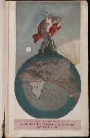
Atlas
Atlas minor: or A new and curious set of sixty two maps, in which are shewn all the empires
Atlas minor: or a set of sixty-two new and correct maps, of all parts of the world. All composed
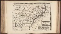
Carolina by H. Moll geographer.
PREVIOUS
«
1
2
»
NEXT
Limit your search
Extent of Digitization
Partially digitized
14
Unspecified
1
Access
Public
15
Repository
Beinecke Rare Book and Manuscript Library
15
Format
cartographic
✖
[remove]
15
Genre
Engravings
14
Illustrations
12
Maps in books
12
Maps
11
Atlases
5
Hand coloring
2
Frontispieces (Illustrations)
1
Title pages
1
prints: intaglio prints: copper engravings (AAT)
1
Resource Type
Maps, Atlases & Globes
4
Language
English
12
French
2
Creator
Moll, Herman, d. 1732
12
Aa, Pieter van der, 1659-1733
2
Danckerts, Justus, 1635-1701
1
Danckerts, Theodore
1
Ferrarius, Philippus, d. 1626
1
Gueudeville, Nicolas, ca. 1654-ca. 1721
1
Subject (Topic)
Atlases--Early works to 1800
✖
[remove]
15
Geography--Early works to 1800
2
Atlases, French
1
Geography--Pictorial works
1
Publication Place
A Leide,
1
Le tout mis en ordre & executé à Leide,
1
London :
1
London,
1
Tot Amsterdam,
1
Date Created
1700
to
1799
✖
[remove]
15
1700
to
1709
1
1710
to
1719
1
1720
to
1729
1
1730
to
1739
11
1740
to
1749
0
1750
to
1759
0
1760
to
1769
0
1770
to
1779
0
1780
to
1789
1
1790
to
1799
0
Current results range from
1703
to
1789
Date Created range begin
Date Created range end
View larger »