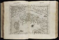
Geografia di Clavdio Tolomeo Alessandrino and Geographia. Italian. 1599
Description:
First printed in Latin in Vicenza in
Publisher:
Appresso gli heredi di Melchior Sessa,
Subject (Geographic):
America--Geography--Maps
Subject (Name):
Rosaccio, Giuseppe, approximately 1530-approximately 1620, Ruscelli, Girolamo, -approximately 1565, and Thorne Collection of Cartogaphy and Geography Bookplate.
Subject (Topic):
Geography, Ancient--Maps and Mathematical geography
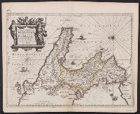
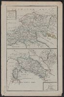
In upper right margin: Taf. VI., Possibly from Ukert's Geographie der Griechen und Römer von den frühesten zeiten bis auf Ptolemäus., and Relief shown by hachures.
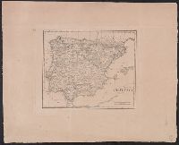
Subject (Geographic):
Spain--Maps
Subject (Name):
Ukert, F. A. (Friedrich August), 1780-1851. Geographie der Griechen und Römer von den frühesten zeiten bis auf Ptolemäus
Hand colored. "Tab. 33"--Manuscript note. Stamp: Karpinski-von Wieser Map Collection., Oriented with north to the left., Relief shown pictorially., and Verso is blank.
Acquaroni, Giovanni, active 1816-approximately 1837, cartographer
Published / Created:
1826
Call Number:
400am R66 1826
Container / Volume:
BRBL_00233
Image Count:
1
Resource Type:
Maps, Atlases & Globes
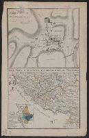
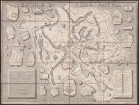
Alternative Title:
Vestigie di Roma antica
Description:
400am R66 1826: Dissected and mounted on linen. Bookseller's label: Venance Monaldini ... Rome., Below lower right margin: "Paoli 15.", Includes index and notes., Relief shown by hachures., and Shows names of Ancient Roman sites, some in fragmentary form with floor plans.
Publisher:
Presso Venanzio Monaldini ... con approvazione e privilegio Pontificio,
Subject (Geographic):
Rome (Italy)--Maps and Rome--Antiquities--Maps
Subject (Name):
Monaldini, Venanzio, Monaldini, Venanzio, bookseller, Nibby, A. (Antonio), 1792-1839, and Romanis, Antonio de
Subject (Topic):
Antiquities, Architecture--Designs and plans, and Geography, Ancient--Maps