Search
You Searched For
Search Results
- Published / Created:
- 1860?]
- Call Number:
- 796gme 1860
- Container / Volume:
- BRBL_00531
- Image Count:
- 1
- Resource Type:
- Maps, Atlases & Globes
- Found in:
- Beinecke Rare Book and Manuscript Library > A geographically correct map of the Red River, Sabine & Western Railway (under construction) and connections : showing distribution of pine forests (compiled from maps of U.S. government), also location of coal, iron, and oil deposits.
- Creator:
- Rand McNally and Company
- Published / Created:
- 1911
- Call Number:
- 795 1911
- Container / Volume:
- BRBL_00521
- Image Count:
- 1
- Resource Type:
- Maps, Atlases & Globes
- Found in:
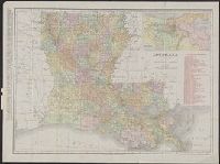
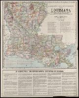
- Beinecke Rare Book and Manuscript Library > Louisiana.
- Creator:
- Rand McNally and Company
- Published / Created:
- 1908
- Call Number:
- 795 1908
- Container / Volume:
- BRBL_00521
- Image Count:
- 2
- Resource Type:
- Maps, Atlases & Globes
- Found in:
- Beinecke Rare Book and Manuscript Library > Louisiana.
- Published / Created:
- [192-?]
- Call Number:
- 795 192X
- Container / Volume:
- BRBL_00521
- Image Count:
- 2
- Resource Type:
- Maps, Atlases & Globes
- Found in:
- Beinecke Rare Book and Manuscript Library > The Department of Agriculture and Immigration's map of Louisiana : showing parishes, parish seats, cities, towns, villages, etc., railroads, with distances between stations, the state highway system - improved and proposed improved roads.