Search
You Searched For
Search Results
- Creator:
- Stanford's Geographical Estabt
- Published / Created:
- [1917?]
- Call Number:
- 11hc 1919W
- Image Count:
- 1
- Resource Type:
- Maps, Atlases & Globes
- Found in:
- Beinecke Rare Book and Manuscript Library > The downfall of Germany's world-empire / Stanford's Geogl. Estabt., London.
- Published / Created:
- 191-.
- Call Number:
- 11hcf 1919-10
- Image Count:
- 1
- Resource Type:
- Maps, Atlases & Globes
- Found in:
- Beinecke Rare Book and Manuscript Library > Voies ferrees a la disposition des forces Américaines.
- Creator:
- Encyclopaedia Britannica, inc
Matthews-Northrup Works
- Published / Created:
- 1918?]
- Call Number:
- 11hc 1918J-2
- Container / Volume:
- BRBL_00010F
- Image Count:
- 1
- Resource Type:
- Maps, Atlases & Globes
- Found in:
- Beinecke Rare Book and Manuscript Library > A geographical and historical guide to the world's wars, 4000 B.C. to 1918 [cartographic material] : No. 1, north-western Europe, showing the "Western Front" / engraved and printed at the Matthews-Northrup Works, Buffalo, N.Y.
- Creator:
- George Philip & Son
London Geographical Institute
- Published / Created:
- [1918?]
- Call Number:
- 11hc 1914P
- Image Count:
- 1
- Resource Type:
- Maps, Atlases & Globes
- Found in:
- Beinecke Rare Book and Manuscript Library > Daily mail war map [cartographic material].
- Published / Created:
- 1915
- Call Number:
- 11hc 1915D
- Image Count:
- 1
- Resource Type:
- Maps, Atlases & Globes
- Found in:
- Beinecke Rare Book and Manuscript Library > De la guerre européenne : feuille nord-est.
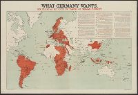
- Published / Created:
- [1916?]
- Call Number:
- 11hc 1914R
- Container / Volume:
- BRBL_00010B
- Image Count:
- 1
- Resource Type:
- Maps, Atlases & Globes
- Found in:
- Beinecke Rare Book and Manuscript Library > What Germany wants : her claims as set forth by leaders of German thought.
- Published / Created:
- 1916
- Call Number:
- 11hc 1916HB
- Container / Volume:
- BRBL_00010C
- Image Count:
- 1
- Resource Type:
- Maps, Atlases & Globes
- Found in:
- Beinecke Rare Book and Manuscript Library > Le Front = Lorraine et Alsace / dressé et dessiné́ par G. Peltier.
- Creator:
- Bumstead, Albert H. (Albert Hoit), 1875-1940
National Geographic Society (U.S.). Cartographic Division
- Published / Created:
- 1918
- Call Number:
- 11hc 1918C
- Container / Volume:
- BRBL_00010E
- Image Count:
- 1
- Resource Type:
- Maps, Atlases & Globes
- Found in:
- Beinecke Rare Book and Manuscript Library > Map of the Western Theatre of War / Prepared in the Map Dept. of the National Geographic Society for the National Geographic Magazine ; A. H. Bumstead, cartographer.
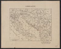
- Creator:
- American Geographical Society of New York
- Published / Created:
- [1918?]
- Call Number:
- 11hcf 1919-14
- Container / Volume:
- BRBL_00010J
- Image Count:
- 1
- Resource Type:
- Maps, Atlases & Globes
- Found in:
- Beinecke Rare Book and Manuscript Library > Adriatic [Sea region].
- Creator:
- Ordnance Survey of Great Britain and Ireland
Royal Geographical Society (Great Britain). Geographical Section
- Published / Created:
- 1915
- Call Number:
- 11hcf 1919E-11
- Image Count:
- 1
- Resource Type:
- Maps, Atlases & Globes
- Found in:
- Beinecke Rare Book and Manuscript Library > Triest : North L 33. / compiled at the Royal Geographical Society under the direction of the Geographical Section; drawn and printed by Ordnance Survey.