Skip to search
Skip to main content
Skip to first result
Search
You Searched For
Date
1700 - 1799
Format
cartographic
Subject (Topic)
World maps--Early works to 1800
Date Created
1700 to 1799
New Search
Search Results
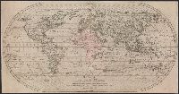
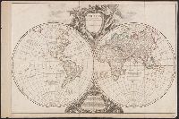
Published / Created:
1782
Call Number:
11 1782
Container / Volume:
BRBL_00681
Image Count:
1
Resource Type:
Maps, Atlases & Globes
Alternative Title:
Carte générale de l'univers and Mappe-Mond
Description:
Map in oval form., Scale measured at center of hemisphere., and Sheets pasted together. Cross collection no. 46.
Publisher:
[s.n.],
Subject (Geographic):
World maps--Early works to 1800
Subject (Name):
Cook, James,--1728-1779--Travel--Maps--To 1800 and Lotter, Matthäus Albrecht, 1741-1810
Subject (Topic):
World maps--Early works to 1800
Found in:
Beinecke Rare Book and Manuscript Library > Mappe-Monde, ou, Carte générale de l'univers : sur une projection nouvelle d'une sphère ovale pour mieux entendre les distances entre L'Europe et Amerique avec le tour du monde du Lieut. Cook et tous les découvertes nouvelles / dessinée et gravée pa
Creator:
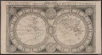
Published / Created:
173-?]
Call Number:
11 1670
Container / Volume:
BRBL_00680
Image Count:
1
Resource Type:
Maps, Atlases & Globes
Description:
A re-issue by Jaillot of Jaugeon's 1688 map--Cf. Shirley, R. Mapping of the world, no. 538., Bernard Jaillot was the son of map maker Alexis Hubert Jaillot., Cross collection no. 21., and Relief shown pictorially.
Publisher:
Barnard Jaillot?,
Subject (Name):
Jaillot, Bernard
Subject (Topic):
World maps--Early works to 1800
Found in:
Beinecke Rare Book and Manuscript Library > Mappe-monde celeste, terrestre et historique [cartographic material].
Creator:
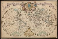
Published / Created:
1720
Call Number:
11 1720
Image Count:
1
Resource Type:
Maps, Atlases & Globes
Description:
Cross collection no. 30., Includes ill., Relief shown pictorially., Shows nautical exploration routes., and Watermark.
Publisher:
Chez Guillaume Delisle, premier geographe du roy, de l'Academie royale des sciences, sur le quay de l'horloge, avec privilege,
Subject (Topic):
Nautical charts., Navigation, and World maps--Early works to 1800
Found in:
Beinecke Rare Book and Manuscript Library > Mappemonde a l'usage du roy [cartographic material] / par Guillaume Delisle, premier geographe de S.M.
Creator:
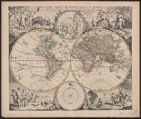
Published / Created:
[1720?]
Call Number:
11 1720A
Container / Volume:
BRBL_00680
Image Count:
1
Resource Type:
Maps, Atlases & Globes
Alternative Title:
Nova orbis tabvla in lvcem edita
Description:
Allegorical vignettes of the four seasons., Cf. Shirley, R. Mapping of the world, no. 545., Cross Collection no. 25., and Double hemisphere, with smaller polar insets.
Publisher:
Apud Ioannem Covens et Cornelium Mortier,
Subject (Name):
Cóvens, Jean and Mortier, Corneille
Subject (Topic):
World maps--Early works to 1800
Found in:
Beinecke Rare Book and Manuscript Library > Nova orbis tabula in lucem edita / a. F. de Wit.
Creator:
Published / Created:
1716?]
Call Number:
11 1716
Container / Volume:
BRBL_00680
Image Count:
1
Resource Type:
Maps, Atlases & Globes
Description:
Cross collection no. 28., Includes text, two celestial insets, two insets of solstices, two panoramic views, and illustrations., and Relief shown pictorially.
Publisher:
s.n.,
Subject (Topic):
World maps--Early works to 1800
Found in:
Beinecke Rare Book and Manuscript Library > Planiglobii terrestris cum utroq hemisphaerio caelesti generalis repraesentatio [cartographic material] : quam ex novissimis probatissimisque recentium geographorum scriptis concinnatam, multisq[ue] phaenomenis illustratam / publice proponit Io. Bapt. Hom
Branch:v1.61.8 ,Deployed:2024-06-20T11:14:48-04:00