Search
You Searched For
Search Results
- Published / Created:
- [18--]
- Call Number:
- 11 1847A
- Image Count:
- 13
- Resource Type:
- Maps, Atlases & Globes
- Found in:
- Beinecke Rare Book and Manuscript Library > [Salisbury Collection of World Maps].
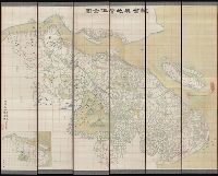
- Creator:
- Li, Mengquan (Cartographer), cartographer.
李蒙泉 (Cartographer), cartographer.
- Call Number:
- Covers 5626 +1880
- Image Count:
- 13
- Resource Type:
- Maps, Atlases & Globes
- Found in:
- Beinecke Rare Book and Manuscript Library > Su Sheng yu di ying wu quan tu / ji yong zhi xian Li Mengquan, Chen Jiaxun tong jian hua.
- Published / Created:
- [1940?-1941]
- Call Number:
- 42 1940
- Container / Volume:
- BRBL_00244
- Image Count:
- 13
- Resource Type:
- Maps, Atlases & Globes
- Found in:
- Beinecke Rare Book and Manuscript Library > [Topographical map of Austria. 1: 25,000].
- Published / Created:
- ca. 1810]
- Call Number:
- 38 V61 1810
- Container / Volume:
- BRBL_00166
- Image Count:
- 13
- Resource Type:
- Maps, Atlases & Globes
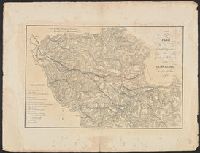
- Found in:
- Beinecke Rare Book and Manuscript Library > [La carte des environs de Versailles dite des Chasses du Roi] / gravé par Doudan, Bouclet et Tardieu l'ainé ; ecrit par Herault, Delahaye.
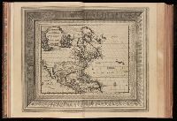
- Creator:
- Aa, Pieter van der, 1659-1733
- Published / Created:
- [1729?]
- Call Number:
- 1973 +32
- Image Count:
- 13
- Resource Type:
- Maps, Atlases & Globes
- Found in:
- Beinecke Rare Book and Manuscript Library > La galerie agreable du monde, ouíÛ l'on voit en un grand nombre de cartes tres-exactes et de belles tailles-douces, les principaux empires, roiíöaumes, republiques, provinces, villes, bourgs et forteresses ... dans les quatre parties de l'univers. Diviseí
- Published / Created:
- 1841
- Call Number:
- 36hc 1796
- Container / Volume:
- BRBL_00133
- Image Count:
- 13
- Resource Type:
- Maps, Atlases & Globes
- Found in:
- Beinecke Rare Book and Manuscript Library > Atlas Principes de la Strategie, par S.A.I. Le Prince Chartes, traduit de l'Allemand par le Général Jomini.
- Creator:
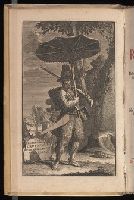
- Defoe, Daniel, 1661?-1731
- Published / Created:
- 1721-22.
- Call Number:
- Defoe 52 p721b
- Image Count:
- 13
- Resource Type:
- Books, Journals & Pamphlets
- Found in:
- Beinecke Rare Book and Manuscript Library > Het leven en de wonderbaare gevallen van Robinson Crusoe : behelzende onder andere ongehoorde uitkomsten een verhaal van zyn agt en twintig jaarig verblyf op een onbewoond eiland, gelegen op de kust van America by de mond van de rivier Oronooque. Alles door liem zelfs beschreven, nu uit het engels vertaald, en met figuren benevens een nette kaart zyner zwerving verrykt : Eerste [-derde] deel.
- Creator:
- Geo. W. Stadly & Co
- Published / Created:
- [186-?]
- Call Number:
- 754hc 1862C
- Container / Volume:
- BRBL_00421
- Image Count:
- 13
- Resource Type:
- Maps, Atlases & Globes
- Found in:
- Beinecke Rare Book and Manuscript Library > [13 maps showing positions of the Union and Confederate armies during the year 1862] / drawn and printed by Geo. W. Stadly & Co.
- Published / Created:
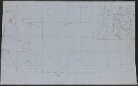
- [1920?]
- Call Number:
- 515 1920
- Container / Volume:
- BRBL_00707
- Image Count:
- 13
- Resource Type:
- Maps, Atlases & Globes
- Found in:
- Beinecke Rare Book and Manuscript Library > [Manuscript maps showing ruin sites etc. in the Transjordan and adjacent areas].
- Creator:
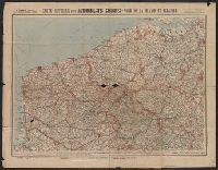
- Cartes Taride (Firm)
- Published / Created:
- 1901-
- Call Number:
- Series 38gmb 1920
- Container / Volume:
- BRBL_00038A
- Image Count:
- 20
- Resource Type:
- Maps, Atlases & Globes
- Found in:
- Beinecke Rare Book and Manuscript Library > Carte routière pour automobilistes & cyclistes [cartographic material] : [France].
- Published / Created:
- 1888
- Call Number:
- 32 Ox1 1768
- Container / Volume:
- BRBL_00052A
- Image Count:
- 20
- Resource Type:
- Maps, Atlases & Globes
- Found in:
- Beinecke Rare Book and Manuscript Library > Sixteen Old Maps of Properties in Oxfordshire (with one in Berkshire) ... Illustrating the open field system. 1605-1768.
- Creator:
- Assam (India). Survey Office
- Published / Created:
- [1943?]
- Call Number:
- 59gm As72 1943
- Container / Volume:
- BRBL_00319
- Image Count:
- 21
- Resource Type:
- Maps, Atlases & Globes
- Found in:
- Beinecke Rare Book and Manuscript Library > Map of Assam showing roads & railways
- Creator:
- Dripps, M. (Matthew)
- Published / Created:
- 1868
- Call Number:
- 771 N49 1868D
- Container / Volume:
- BRBL_00487
- Image Count:
- 21
- Resource Type:
- Maps, Atlases & Globes
- Found in:
- Beinecke Rare Book and Manuscript Library > Plan of New York City from the Battery to Spuyten Duyvil Creek : showing every lot and building thereon; old farm lines, street numbers at the corners of blocks, railroads, steamboat landings, bulkhead and pier lines, etc., etc., etc. / based on the surve
- Creator:
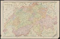
- Woerl, Joseph Edmund, creator
- Call Number:
- 37 1835
- Container / Volume:
- BRBL_00148
- Image Count:
- 19
- Resource Type:
- Maps, Atlases & Globes
- Found in:
- Beinecke Rare Book and Manuscript Library > Karte der Schweiz / von Dr. I. Woerl.
- Creator:
- King, Nicholas, d. 1812
- Published / Created:
- [1888]
- Call Number:
- 779 W27 1803
- Container / Volume:
- BRBL_00505
- Image Count:
- 19
- Resource Type:
- Maps, Atlases & Globes
- Found in:
- Beinecke Rare Book and Manuscript Library > The King plats of the city of Washington in the District of Columbia 1803.
- Creator:
- Maury, Matthew Fontaine, 1806-1873
- Published / Created:
- [1847?]-1853.
- Call Number:
- 11cfk 1850A-3
- Container / Volume:
- BRBL_00768
- Image Count:
- 4
- Resource Type:
- Maps, Atlases & Globes
- Found in:
- Beinecke Rare Book and Manuscript Library > Wind and current chart of the South Atlantic [cartographic material] / by M.F. Maury, L.L.D.U.S. Navy, Superindt. of U.S.N. Observatory ; compiled from materials in the Bureau of Ordnance and Hydrography, Commodore Charles Morris, Chief of Bureau.
- Creator:
- Maury, Matthew Fontaine, 1806-1873
- Published / Created:
- 1852
- Call Number:
- 11cfk 1850D-2
- Container / Volume:
- BRBL_00773
- Image Count:
- 4
- Resource Type:
- Maps, Atlases & Globes
- Found in:
- Beinecke Rare Book and Manuscript Library > Wind and current chart of the South Atlantic [cartographic material] / by M.F. Maury, L.L.D. Lieut. U.S. Navy, Superint'dt. of U.S.N. Observatory ; compiled from materials in the Bureau of Ordnance and Hydrography, Commodore Charles Morris, Chief of Bureau.
- Creator:
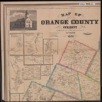
- Walling, Henry Francis, 1825-1888
- Published / Created:
- 1858, c1856.
- Call Number:
- 763 Or1 1858
- Container / Volume:
- BRBL_00452
- Image Count:
- 4
- Resource Type:
- Maps, Atlases & Globes
- Found in:
- Beinecke Rare Book and Manuscript Library > Map of Orange County, Vermont / from surveys under the direction of H.F. Walling ; engraved, printed, colored & mounted at H.F. Walling's map establishment.
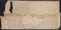
- Published / Created:
- 1652?]
- Call Number:
- 11 1652
- Container / Volume:
- BRBL_00732
- Image Count:
- 4
- Resource Type:
- Maps, Atlases & Globes
- Found in:
- Beinecke Rare Book and Manuscript Library > Tabvla itineraria ex illustri Peutingerorum, bibliotheca quae Augustae Vindelicorum / beneficio Marci Velseri, septem-viri Augustani in lucem edita.
- Creator:
- Geological Survey (U.S.)
- Published / Created:
- 193-?]
- Call Number:
- 71 1755Q
- Container / Volume:
- BRBL_00364
- Image Count:
- 4
- Resource Type:
- Maps, Atlases & Globes
- Found in:
- Beinecke Rare Book and Manuscript Library > The Mitchell map of the British and French dominions in North America, 1755.