Skip to search
Skip to main content
Skip to first result
Search
You Searched For
"Latin"
Access
Public
Format
cartographic
New Search
Search Results
Creator:
Published / Created:
1522?]
Call Number:
66 1522
Container / Volume:
BRBL_00347
Image Count:
2
Resource Type:
Maps, Atlases & Globes
Alternative Title:
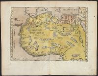
Partis Aphricae, et tabula secunde partis Aphricae
Description:
Verso: Latin text, Masonic square and
Subject (Geographic):
Africa, North--Maps--Early works to 1800
Subject (Name):
Freemasons--Insignia--Maps--Early works to 1800
Found in:
Beinecke Rare Book and Manuscript Library > [Map of northern Africa].
Call Number:
Taylor 192 4-6
Collection Title:
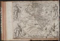
Americae pars sexta, sive, Historiae ab Hieronymo Be[n]zono Mediolane[n]se scriptae, sectio tertia
Image Count:
1
Subject (Geographic):
America --Early accounts to 1600, Canary Islands --Description and travel --Early works to 1800, Florida --History --Huguenot colony, 1562-1565, Peru --History --Conquest, 1522-1548, and Western Hemisphere --Maps --
Subject (Name):
del Mondo Nuovo. Book 3. Latin
Collection Created:
[Frankfurt am Main : Theodore de Bry, 1596]
Found in:
Beinecke Rare Book and Manuscript Library > America Sive Novus Orbis Respectu Europaeorum Inferior Globe Terrestris Pars 1596
Creator:
Published / Created:
[1717?]
Call Number:
51 1717
Container / Volume:
BRBL_00278
Image Count:
1
Resource Type:
Maps, Atlases & Globes
Alternative Title:
Sainte Bible en latin et en françois.
Description:
Desessartz' La Sainte Bible en latin et françois
Publisher:
Chez Guillaume Desprez ... et Jean Desessartz, rue S. Jacques, à l'Enseigne de S. Prosper et des tres Vertus,
Subject (Geographic):
Palestine--History--To 70 A.D.--Maps and Palestine--Maps--Early works to 1800
Subject (Name):
Delamonce, Ferdinand, 1678-1753, Desessartz, Jean, Desprez, Guillaume, and Scotin, G
Subject (Topic):
Bible.--O.T.--Geography--Maps, Jews--History--To 586 B.C.--Maps, and Twelve tribes of Israel--Maps--Early works to 1800
Found in:
Beinecke Rare Book and Manuscript Library > Description geographique de la Terre Promise, terre des Hebreux, et des Isráelites, partagée selon l'ordre de Dieu aux Douze Tribus descendantes des douze fils de Jacob ... pour le Livre de Josué / dressé pour la lecture de l'Ecriture Sainte par le Sr
Creator:
Published / Created:
[1647]
Call Number:
755 1647
Container / Volume:
BRBL_00422
Image Count:
2
Resource Type:
Maps, Atlases & Globes
Alternative Title:
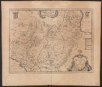
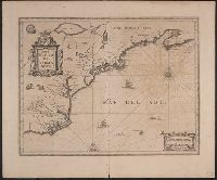
Atlas novus.
Description:
Appears in Latin editions of Jansson's
Publisher:
Johannes Janssonius excudit,
Subject (Geographic):
Atlantic States--Maps--Early works to 1800 and Maritime Provinces--Maps--Early works to 1800
Subject (Name):
Jansson, Jan, 1588-1664. Atlas novus
Found in:
Beinecke Rare Book and Manuscript Library > Nova Belgica et Anglia Nova.
Creator:
Published / Created:
1596]
Call Number:
64 1596
Container / Volume:
BRBL_00337
Image Count:
1
Resource Type:
Maps, Atlases & Globes
Alternative Title:
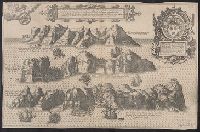
Afheeldinghe der custen des landts Guinea, Manicongo, ende Angôla, ende voorts tot voorby de C. de boa esperança and Delineatio orarum maritimarum, terrae vulgo indigetatae terra do Natal item Sofalae, Mozambicae & Melindae ...
Description:
Title in Latin and Dutch. Place names
Publisher:
Arnold Florent van Langren,
Subject (Geographic):
Africa, Southern--Maps--Early works to 1800
Subject (Name):
Langren, Arnold Florent van, 1580-1644 and Linschoten, Jan Huygen van, 1563-1611. Itinerario, voyage ofte schipvaert van Jan Huygen van Linschoten naer Oost ofte Portugaels Indien
Subject (Topic):
Coasts--Africa, Southern--Maps--Early works to 1800
Found in:
Beinecke Rare Book and Manuscript Library > Typus orarum maritimarum Guineae, Manicongo, & Angôlae ultra promontorium Bonae Spei ... [cartographic material] = Afheeldinghe der custen des landts Guinea, Manicongo, ende Angôla, ende voorts tot voorby de C. de boa esperança ... / Arnoldus F. á Lan
Published / Created:
1635?]
Call Number:
394 1635
Container / Volume:
BRBL_00193
Image Count:
2
Resource Type:
Maps, Atlases & Globes
Alternative Title:
Biscaia et Gvipvscoa, Cantabriae veteris pars
Description:
Latin on recto, verso.
Publisher:
Blaeu,
Subject (Geographic):
Guipúzcoa (Spain)--Maps--Early works to 1800 and Vizcaya (Spain)--Maps--Early works to 1800
Found in:
Beinecke Rare Book and Manuscript Library > Biscaia et Guipuscoa, Cantabriae veteris pars.
Branch:v1.61.6 ,Deployed:2024-06-12T09:55:31-04:00