Search
You Searched For
Search Results
- Published / Created:
- Decemr. 1766.
- Call Number:
- 732cea 1766
- Container / Volume:
- BRBL_00377
- Image Count:
- 1
- Resource Type:
- Maps, Atlases & Globes
- Publisher:
- the Author,
- Found in:
- Beinecke Rare Book and Manuscript Library > A draught of the harbour of Hallifax, and the adjacent coast in Nova Scotia / survey'd by order of Commodore Spry by James Cook, when master of His Majesty's ship the Mars ; Emanl. Bowen, sculpt.
- Creator:
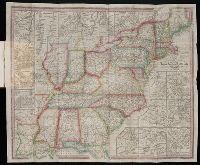
- Tanner, Henry Schenck, 1786-1858
- Published / Created:
- 1839
- Call Number:
- CE158 T35 1839
- Collection Title:
- The American traveller; or, Guide through the United States
- Image Count:
- 1
- Resource Type:
- Maps, Atlases & Globes
- Publisher:
- The author
- Found in:
- Beinecke Rare Book and Manuscript Library > The Travellers Guide or Map of the Roads, Canals and Railroads of the United States with distances from place to place
- Creator:
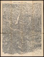
- Dorman, Moses, author.
- Published / Created:
- 1830
- Call Number:
- 764 An23 1830
- Image Count:
- 1
- Resource Type:
- Maps, Atlases & Globes
- Found in:
- Beinecke Rare Book and Manuscript Library > A plan of Andover taken for the town / by Moses Dorman, Jr.
- Creator:
- Artaria & Co., author.
- Published / Created:
- [between 1910 an 1919?]
- Call Number:
- 424 1910
- Container / Volume:
- BRBL_00245
- Image Count:
- 2
- Resource Type:
- Maps, Atlases & Globes
- Found in:
- Beinecke Rare Book and Manuscript Library > Artaria's neueste Touristen-karten im Massstabe von 1:129,600.
- Creator:
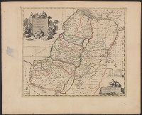
- Mortier, Pierre, author
- Call Number:
- 51 1705
- Container / Volume:
- BRBL_00278
- Image Count:
- 1
- Resource Type:
- Maps, Atlases & Globes
- Found in:
- Beinecke Rare Book and Manuscript Library > Carte de la Terre Sainte : divisée selon les douze tribus d'Isreal ou sont exactement marquez les voyages de Iésus Christ &c. : dressée pour bien entendre les histoires de la Bible / par le sain de Pierre Mortier ; I. van Luchtenburg delin. et schulp.
- Creator:
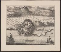
- Mortier, Pierre, author
- Call Number:
- 462 1721
- Container / Volume:
- BRBL_00260
- Image Count:
- 1
- Resource Type:
- Maps, Atlases & Globes
- Found in:
- Beinecke Rare Book and Manuscript Library > Castell-novo : aux Venetiens dans le Dalmatie / par Pierre Mortier.
- Creator:
- Hausermann, R., author.
- Published / Created:
- [1877]
- Call Number:
- BrSides 2019 88
- Image Count:
- 1
- Resource Type:
- Maps, Atlases & Globes
- Found in:
- Beinecke Rare Book and Manuscript Library > Plan de Saint Louis (Sénégal) : d'après les cartes hydrographiques de la Marine / dressée par R. Hausermann.
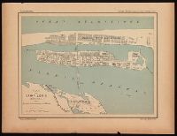
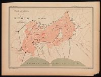
- Creator:
- Hausermann, R., author.
- Published / Created:
- [1877]
- Call Number:
- BrSides 2019 89
- Image Count:
- 1
- Resource Type:
- Maps, Atlases & Globes
- Found in:
- Beinecke Rare Book and Manuscript Library > Plan de Tunis / dressée par R. Hausermann.
- Creator:
- Bowen, Emanuel, d. 1767
Cook, James, fl. 1766, creator
- Published / Created:
- Decr. 1766
- Call Number:
- 2003 Folio 85
- Image Count:
- 1
- Publisher:
- By the author
- Found in:
- Beinecke Rare Book and Manuscript Library > A draught of Port Royal Harbour in South Carolina: with the marks for going in : most humbly inscribed to the publick
- Creator:
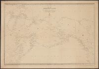
- Russia. Gidrograficheskīĭ departament, author
- Call Number:
- 23cea 1858
- Container / Volume:
- BRBL_00021
- Image Count:
- 1
- Resource Type:
- Maps, Atlases & Globes
- Found in:
- Beinecke Rare Book and Manuscript Library > Karta Ledovitago mori︠a︡ i Vostochnago okeana / sostavlena s novi︠e︡ĭshikh opiseĭ v Geograficheskom departamenti︠e︡ Morskago ministerstva.