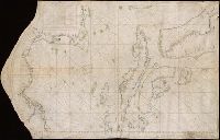
Search
You Searched For
Search Results
- Published / Created:
- [ca. 1760]
- Call Number:
- 85cea 1760
- Container / Volume:
- BRBL_00719
- Image Count:
- 2
- Resource Type:
- Maps, Atlases & Globes
- Found in:
- Beinecke Rare Book and Manuscript Library > [Manuscript map of the West Indies].
- Published / Created:
- 1764
- Call Number:
- 764 1764
- Container / Volume:
- BRBL_00710
- Image Count:
- 1
- Resource Type:
- Maps, Atlases & Globes
- Found in:
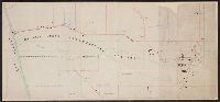
- Beinecke Rare Book and Manuscript Library > [Manuscript map of the Western boundaries of Massachusetts] sworn this line has bin measured this year 1764 ... a true copy N. Dwight. Saml. Messinger surveyor.
- Published / Created:
- [1750]
- Call Number:
- 655gmg 1750
- Container / Volume:
- BRBL_00708
- Image Count:
- 1
- Resource Type:
- Maps, Atlases & Globes
- Found in:
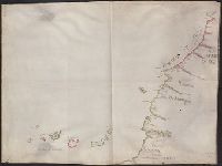
- Beinecke Rare Book and Manuscript Library > [Manuscript map of the coastline of Western Africa].
- Published / Created:
- [between 1800 and 1810?]
- Call Number:
- BrSides Double Folio 2018 83
- Image Count:
- 1
- Resource Type:
- Maps, Atlases & Globes
- Found in:
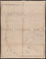
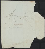
- Beinecke Rare Book and Manuscript Library > [Manuscript map of the coastline of the Gulf of Mexico from the border of Louisiana and Texas to the Yucatán Peninsula].
- Published / Created:
- [after 1842]
- Call Number:
- BrSides Elephant Folio 2018 19
- Image Count:
- 1
- Resource Type:
- Maps, Atlases & Globes
- Found in:
- Beinecke Rare Book and Manuscript Library > [Manuscript map of the northern third of Maine].
- Published / Created:
- [between 1840 and 1849?]
- Call Number:
- BrSides Folio 2018 146
- Image Count:
- 1
- Resource Type:
- Maps, Atlases & Globes
- Found in:
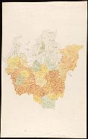
- Beinecke Rare Book and Manuscript Library > [Manuscript map of the regions in northern Italy].
- Published / Created:
- 1728
- Call Number:
- 764gmb B65 1728
- Container / Volume:
- BRBL_00711
- Image Count:
- 1
- Resource Type:
- Maps, Atlases & Globes
- Found in:
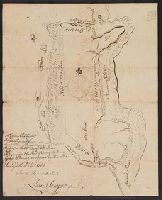
- Beinecke Rare Book and Manuscript Library > [Manuscript map of the road from Boston to East Milton].
- Published / Created:
- 1850
- Call Number:
- 771 Se56 1850
- Container / Volume:
- BRBL_00713
- Image Count:
- 1
- Resource Type:
- Maps, Atlases & Globes
- Found in:
- Beinecke Rare Book and Manuscript Library > [Manuscript map of] New York State Agricultural College Farm.
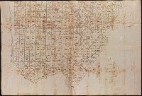
- Published / Created:
- 1762
- Call Number:
- 785 P265 1762
- Container / Volume:
- BRBL_00715
- Image Count:
- 1
- Resource Type:
- Maps, Atlases & Globes
- Found in:
- Beinecke Rare Book and Manuscript Library > [Manuscript map of] North Carolina Pasquotank County.
- Published / Created:
- [1846?]
- Call Number:
- 54635 K836 1846
- Container / Volume:
- BRBL_00707
- Image Count:
- 1
- Resource Type:
- Maps, Atlases & Globes
- Found in:
- Beinecke Rare Book and Manuscript Library > [Manuscript map showing part of the Bering Island or Komandor Islands and the position of the wreck of the ship "Baltic" out of New Bedford].