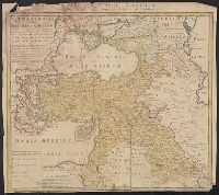
"Cum priv: poten: D.D. ord: Holl: et West-Frisiae"., Appeared in Valk and Schenk's Atlantis sylloge compendiosa, ca. 1702., Backed with paper. Ms. no. "35" in upper left-hand corner. Sheet measures 53.6 x 62.5 cm. No. 34 of 87 maps bound together., Bar scales given in "milliaria Germanica," "milliaria Gallica," and "milliaria Italica"., Prime meridian: Ferro., Relief shown pictorially., and Watermark.
Publisher:
Gerard Valk,
Subject (Geographic):
Rhineland-Palatinate (Germany)--Maps--Early works to 1800.
Subject (Name):
Schenk, Peter, 1660-1718 or 1719. Atlantis sylloge compendiosa. and Valck, G. (Gerard), 1651 or 2-1726. Atlantis sylloge compendiosa.
Tribvs Aser, et partes occidentales tribuum Zabvlon et Isachar
Description:
Appears in Jansson's historical atlas editions from 1652-1684 and in his Accuratissima orbis antiqui delineatio. From 1653 on, this work is known under the name of Hornius, who wrote the text and compiled all the maps for the atlases--(Koeman-Krogt. 1:601-1:607)., Coordinates not present on map and are approximated., Map indexed with grid lines and alphabet letters A-H at bottom., Oriented with north toward the left., Printed on one and a half sheets., Relief shown pictorially., Shows the Tribe of Asher and the western parts of Zabulon and Isachar., and Watermark. Manuscript numbers in upper left and right corners: 43. No. 3 of 6 maps housed together.
Publisher:
[Jan Jansson],
Subject (Geographic):
Palestine--History--To 70 A.D.--Maps--Early works to 1800. and Palestine--Maps--Early works to 1800.
Appears in: Theatrum Terrae Sanctae et biblicarum historiarum / Christiaan van Adrichem. Colonia Agrippina : Birckmannica, 1590., Cartographer from dealer's notes., Has watermark., Oriented with north toward the left., Relief shown pictorially., and Shows portion
Publisher:
Birckmannica,
Subject (Geographic):
Palestine--History--To 70 A.D.--Maps and Palestine--Maps--Early works to 1800
Appears in 1590 and 1682 eds. of Theatrum terrae., Laor contributes this map to Christian van Adrichom in Cologne, ca. 1590., Oriented to the east., Relief shown pictorially., and Shows portion of the Holy Land given to the Tribe of Reuben at the time of the divi
Publisher:
Birckmannica,
Subject (Geographic):
Palestine--History--To 70 A.D.--Maps and Palestine--Maps--Early works to 1800
Subject (Name):
Adrichem, Chirstiaan van, 1533-1585. Theatrum Terrae Sanctae and Birckmann, Johann, 1527-1572
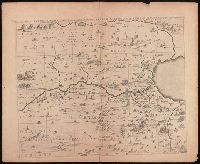
Tribuum Ephraim, Beniamin, et Dimidiae, Manasse intra Jordanem partes occidentales, et partes septentrionales Dan et Juda
Description:
Appears in Jansson's historical atlas editions from 1652-1684 and in his Accuratissima orbis antiqui delineatio. From 1653 on, this work is known under the name of Hornius, who wrote the text and compiled all the maps for the atlases--(Koeman-Krogt. 1:601-1:607)., Coordinates not present on map and are approximated., Map indexed with grid lines and alphabet letters I[J]-O at bottom., Oriented with north toward the left., Relief shown pictorially., and Watermark. Manuscript number in upper left corner: 44. No. 2 of 6 maps housed together.
Publisher:
[Jan Jansson],
Subject (Geographic):
Palestine--History--To 70 A.D.--Maps--Early works to 1800. and Palestine--Maps--Early works to 1800.
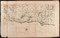
Tribus Ruben, et Gad et partes orientales tribuum Benjamin, Ephraim, et dimidiae Manasse intra Jordanem
Description:
Appears in Jansson's historical atlas editions from 1652-1684 and in his Accuratissima orbis antiqui delineatio. From 1653 on, this work is known under the name of Hornius, who wrote the text and compiled all the maps for the atlases--(Koeman-Krogt. 1:601-1:607)., Coordinates not present on map and are approximated., Includes many biblical scenes and notes., Manuscript number in upper left corner: 47. No. 1 of 6 maps housed together., Map indexed with grid lines and alphabet letters J-O at top of map under title., Map of the Hebrew tribes of Reuben and Gad, with the eastern parts of the tribes of Benjamin, Ephraim, and half of Manasseh beyond the Jordan River., Oriented with north to the left., Relief shown pictorially., and The first map drawn of a series of six sheets that form an enlarged adaptation of Andrichom's "Sitius Terrae Promissionis". This map is the sheet positioned at top, center.
Publisher:
[Jan Jansson],
Subject (Geographic):
Middle East--Palestine. and Palestine--History--To 70 A.D.--Maps--Early works to 1800.
Tribus Simeon et pars meridionalis tribus Dan, et orientalis tribus Juda
Description:
Appears in Jansson's historical atlas editions from 1652-1684 and in his Accuratissima orbis antiqui delineatio. From 1653 on, this work is known under the name of Hornius, who wrote the text and compiled all the maps for the atlases--(Koeman-Krogt. 1:601-1:607)., Coordinates not present on map and are approximated., Map indexed with grid lines and alphabet letters P-V at bottom., Oriented with the north toward the left., Relief shown pictorially., Shows the tribe of Simeon, the southern part of the tribe of Dan, and the eastern part of Judah. Many Biblical illustrations on map., and Watermark. Manuscript number in upper left corner: 45. No. 6 of 6 maps housed together.
Publisher:
[Jan Jansson],
Subject (Geographic):
Palestine--History--To 70 A.D.--Maps--Early works to 1800. and Palestine--Maps--Early works to 1800.
Carte de la Turquie Asiatique contenant la Natolie Moderne divisée en fes Beglerbeys &.
Description:
"C.P.S.C.M.", Bar scales given in "milliaria Germanica," "milliaria Turcica terrestria," and "milliaria Turcica marina"., Imperfect: chewed at edges, witn some loss of text. Sheet measures 48.6 x 54.7 cm., Prime meridian: Ferro., Relief shown pictorially., and Wat
Publisher:
Impensis Homannianorum Heredum,
Subject (Geographic):
Middle East--Maps--Early works to 1800 and Turkey--Maps--Early works to 1800