Search
You Searched For
Search Results
- Creator:
- Geological and Geographical Survey of the Territories (U.S.)
- Published / Created:
- [1878?]
- Call Number:
- 833ca 1878C
- Container / Volume:
- BRBL_00585
- Image Count:
- 1
- Resource Type:
- Maps, Atlases & Globes
- Found in:
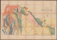
- Beinecke Rare Book and Manuscript Library > Geological map of portions of Wyoming, Idaho and Utah / Department of the Interior, U.S. Geological and Geographical Survey of the Territories ; F.V. Hayden, U.S. geologist in charge ; geology by A.C. Peale, Orestes St. John and F.M. Endlich.
- Published / Created:
- 1889
- Call Number:
- 773 M75 1889
- Container / Volume:
- BRBL_00496
- Image Count:
- 1
- Resource Type:
- Maps, Atlases & Globes
- Found in:
- Beinecke Rare Book and Manuscript Library > A topographical map of the Monmouth shore, with the interior from Metuchen to Lakewood : from original surveys and levelings, based upon the triangulation of the U.S. Coast and Geodetic Survey / George H. Cook, state geologist ; C.C. Vermeule, topographer
- Published / Created:
- 1890
- Call Number:
- 773 M75 1890
- Container / Volume:
- BRBL_00496
- Image Count:
- 1
- Resource Type:
- Maps, Atlases & Globes
- Found in:
- Beinecke Rare Book and Manuscript Library > A topographical map of the Monmouth shore, with the interior from Metuchen to Lakewood : from original surveys and levelings, based upon the triangulation of the U.S. Coast and Geodetic Survey / George H. Cook, state geologist ; C.C. Vermeule, topographer
- Creator:
- Geological and Geographical Survey of the Territories (U.S.)
- Published / Created:
- 1876?]
- Call Number:
- 836ca G825 1873
- Container / Volume:
- BRBL_00593
- Image Count:
- 1
- Resource Type:
- Maps, Atlases & Globes
- Found in:
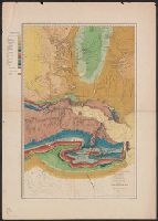
- Beinecke Rare Book and Manuscript Library > Green River from the Union Pacific Rail Road to the mouth of White River, 1873 / Department of the Interior, U.S. Geological and Geographical Survey of the Territories, Second Division, J.W. Powell geologist in charge ; A.H. Thompson, geographer ; H.C. De
- Creator:
- Geological and Geographical Survey of the Territories (U.S.)
- Published / Created:
- 1876?]
- Call Number:
- 836g G825 1873
- Container / Volume:
- BRBL_00593
- Image Count:
- 1
- Resource Type:
- Maps, Atlases & Globes
- Found in:
- Beinecke Rare Book and Manuscript Library > Green River from the Union Pacific Rail Road to the mouth of White River, 1873 / Department of the Interior, U.S. Geological and Geographical Survey of the Territories, Second Division, J.W. Powell geologist in charge ; A.H. Thompson, geographer ; H.C. De
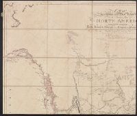
- Creator:
- Arrowsmith, Aaron, 1750-1823
- Published / Created:
- [1818]
- Call Number:
- 71 1818A
- Container / Volume:
- BRBL_00368
- Image Count:
- 4
- Resource Type:
- Maps, Atlases & Globes
- Found in:
- Beinecke Rare Book and Manuscript Library > A map exhibiting all the new discoveries in the interior parts of North America : inscribed by permission to the honourable governor and company of adventurers of England trading into Hudsons Bay in testimony of their liberal communications to their most
- Creator:
- United States. General Land Office
- Published / Created:
- 1908
- Call Number:
- 824 1908
- Container / Volume:
- BRBL_00570
- Image Count:
- 1
- Resource Type:
- Maps, Atlases & Globes
- Found in:
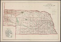
- Beinecke Rare Book and Manuscript Library > State of Nebraska / Department of the Interior, General Land Office ; compiled from the official records of the General Land Office and other sources under the direction of I.P. Berthrong ; compiled by A.F. Dinsmore ; traced and lettered by Wm. Bauman, Jr
- Creator:
- Geological Survey of Canada
- Published / Created:
- 1905
- Call Number:
- 741GBC 1905
- Container / Volume:
- BRBL_00395
- Image Count:
- 1
- Resource Type:
- Maps, Atlases & Globes
- Found in:
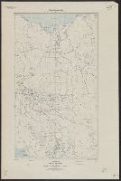
- Beinecke Rare Book and Manuscript Library > Map of the Yukon Territory to illustrate the summary report of R.G. McConnell, Jos. Keele, and C. Camsell / compiled by J. Keele from the surveys made by officers of the Geological Survey of Canada, the Department of the Interior, the U.S. Geological Surv
- Creator:
- Arrowsmith, Aaron, 1750-1823, cartographer.
- Call Number:
- 71 1811
- Image Count:
- 4
- Resource Type:
- Maps, Atlases & Globes
- Found in:
- Beinecke Rare Book and Manuscript Library > A map exhibiting all the new discoveries in the interior parts of North America [cartographic material] / inscribed by permission to the honorable governor and company of the adventurers of England trading into Hudsons Bay, in testimony of their liberal communications to their most obedient and very humble servant A. Arrowsmith, hydrographer to H.R.H. the Prince of Wales, January 1st 1795 ; Puke, sc.