Search
You Searched For
Search Results
- Creator:
- Ordnance Survey of Great Britain and Ireland
Royal Geographical Society (Great Britain). Geographical Section
- Published / Created:
- 1915
- Call Number:
- 11hcf 1919E-12
- Image Count:
- 1
- Resource Type:
- Maps, Atlases & Globes
- Alternative Title:
- Europe 1:1,000,000, G.S.G.S. ; no. 2758, and GSGS (Series) ; no. 2758.
- Description:
- Includes index to adjoining sheets, index to boundaries, and pronunciation glossary.
- Publisher:
- Ordnance Survey,
- Subject (Geographic):
- Europe, Eastern--Maps
- Subject (Topic):
- World War, 1914-1918--Maps
- Found in:
- Beinecke Rare Book and Manuscript Library > (Warsaw) Varshava : North N. 34. / compiled at the Royal Geographical Society under the direction of the Geographical Section; drawn and printed by Ordnance Survey.
- Creator:
- Great Britain. Foreign Office
Justus Perthes (Firm : Gotha, Germany)
Moras, Ferdinand, 1821-1908
Petermann, A. (August Heinrich), 1822-1878
- Published / Created:
- 1854
- Call Number:
- Folio 296
- Image Count:
- 1
- Resource Type:
- Books, Journals & Pamphlets
- Description:
- Hand colored map.
- Publisher:
- Published for the author by E. Stanford; [etc., etc.]
- Subject (Geographic):
- Africa, Central --Maps and Africa, Central--Description and travel
- Subject (Name):
- Overweg, Adolf,--1822-1852, Richardson, James,--1806-1851, and Vogel, Eduard,--1829-1856
- Found in:
- Beinecke Rare Book and Manuscript Library > ... An account of the progress of the expedition to Central Africa, performed by order of Her Majesty's Foreign office, under Messrs. Richardson, Barth, Overweg & Vogel, in the years 1850, 1851, 1852, and 1853. Consisting of maps and illustrations, with descriptive notes, constructed and comp. from official and private materials by Augustus Petermann ...
- Published / Created:
- 1850
- Call Number:
- 1976 Folio 96
- Collection Title:
- A new universal atlas containing maps of the various empires, kingdoms, states and republics of the
- Image Count:
- 1
- Resource Type:
- Maps, Atlases & Globes
- Publisher:
- Thomas, Cowperthwait & Co
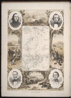
- Subject (Geographic):
- Connecticut
- Collection Created:
- Philadelphia, Cowperthwait, DeSilver & Butler, 1854, c1850
- Found in:
- Beinecke Rare Book and Manuscript Library > 10. Map of Connecticut