Skip to search
Skip to main content
Skip to first result
Search
You Searched For
Date
Unknown
Format
cartographic
Date Created
[Missing]
Search Results
Creator:
Call Number:
85 1745A
Container / Volume:
BRBL_00636
Image Count:
1
Resource Type:
Maps, Atlases & Globes
Alternative Title:
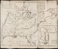
Chart of the West-Indies or the islands of America in the North Sea
Description:
"P. 734, v. 11."
Publisher:
s.n., 1745?]
Subject (Geographic):
Caribbean Area--Maps--Early works to 1800 and West Indies--Maps--Early works to 1800
Subject (Topic):
Coasts--North America--Maps--Early works to 1800 and Coasts--South America--Maps--Early works to 1800
Found in:
Beinecke Rare Book and Manuscript Library > A chart of ye West-Indies or the islands of America in the North Sea &c., being ye present seat of war / by Herman Moll, geographer.
Creator:
Call Number:
755 1776G
Container / Volume:
BRBL_00430
Image Count:
1
Resource Type:
Maps, Atlases & Globes
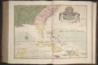
Alternative Title:
Northern British Colonies and Seat of war, in the northern colonies, containing the province of Quebec, Newfoundland, Nova-Scotia, New-England, New-York, New-Jersey, Pennsylvania, and Maryland
Description:
For variant (earlier) issue of map, see B.B. McCorkle, New England in early printed maps, 776.11.
Subject (Geographic):
Canada--Maps--Early works to 1800 and New England--Maps--Early works to 1800
Subject (Name):
Holland, Samuel, 1728-1801, Pownall, Thomas, 1722-1805, and Robert Sayer and John Bennett (Firm). American military pocket atlas
Found in:
Beinecke Rare Book and Manuscript Library > A general map of the Northern British Colonies in America, which comprehends the Province of Quebec, the government of Newfoundland, Nova-Scotia, New-England and New York : from the surveys of Capt. Cook & Capt. Carver, regulated by the astronomic & trigo
Creator:
Call Number:
Egg +755E
Collection Title:
Geographical, historical, political, philosophical and mechanical essays : the first, containing an
Image Count:
1
Description:
Hand-colored illustrations.
Subject (Geographic):
Erie, Lake., Middle Atlantic States--Maps., Ohio River Valley--Maps., and Ontario, Lake (N.Y. and Ont.)
Subject (Topic):
Voyages and travels
Collection Created:
Philadelphia: Printed by B. Franklin, and D. Hall. MDCCLV. And sold by R. and J. Dodsley, in Pall-Mall, London. [1755]
Found in:
Beinecke Rare Book and Manuscript Library > A general map of the middle British colonies in America
Creator:
Call Number:
755 1776K
Container / Volume:
BRBL_00430
Image Count:
1
Resource Type:
Maps, Atlases & Globes
Alternative Title:
Northern British Colonies and Seat of war, in the northern colonies, containing the province of Quebec, Newfoundland, Nova-Scotia, New-England, New-York, New-Jersey, Pennsylvania, &ca.
Description:
From Robert Sayer and John Bennett's American military pocket atlas (1776).
Subject (Geographic):
Canada--Maps--Early works to 1800 and New England--Maps--Early works to 1800
Subject (Name):
Holland, Samuel, 1728-1801, Pownall, Thomas, 1722-1805, and Robert Sayer and John Bennett (Firm). American military pocket atlas
Found in:
Beinecke Rare Book and Manuscript Library > A general map of the northern British colonies in America : which comprehends the province of Quebec, the government of Newfoundland, Nova-Scotia, New-England and New-York, from the maps published by the Admiralty and Board of Trade, regulated by the astr
Creator:
Call Number:
1976 Folio 139
Collection Title:
The English pilot: describing the sea-coasts, capes, head-lands, soundings, sands, shoals, rocks
Image Count:
1
Subject (Topic):
Nautical charts--Europe--To 1800
Collection Created:
[London, Printed by J. Darby] and are to be sold by the author at the signe of the Marriners Compass, at the Hermitage-stairs in Wapping [1671-72]
Found in:
Beinecke Rare Book and Manuscript Library > A large description of the two chanells in the River Dwina goeing up to the citty of Archangel by John Seller
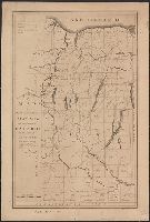
Call Number:
774 B856 1820
Container / Volume:
BRBL_00499
Image Count:
1
Resource Type:
Maps, Atlases & Globes
Subject (Geographic):
Pennsylvania--Maps
Found in:
Beinecke Rare Book and Manuscript Library > A map of Buck Mountain coal company mines exhibiting their relative position to the Lehigh slack water navigation and the different coal mines now opened in the region. Drawn by A.L. Foster of J. Collins 1820 (?) Lith.
Call Number:
Egi M6 722
Collection Title:
A description of the English province of Carolana, by the Spaniards call'd Florida, and by the
Image Count:
1
Alternative Title:
Inset map of the Mouth of the River Meshacebe
Description:
Preceding p. 1.
Subject (Geographic):
Florida --Description and travel, Louisiana --Description and travel --Early works to 1800, and Mississippi River Valley --Description and travel
Collection Created:
London, Printed for B. Cowse, 1722
Found in:
Beinecke Rare Book and Manuscript Library > A map of Carolana and of the River Meschacebe & c.
Call Number:
SS55 75
Collection Title:
The natural history of Carolina, Florida, and the Bahama Islands : containing the figures of birds
Image Count:
1
Description:
Following p. 100.
Subject (Geographic):
Bahamas --Natural history, Florida --Natural history, North Carolina --Natural history, and South Carolina --Natural history
Subject (Topic):
Natural history --Bahamas, Natural history --North Carolina, Natural history --Pictorial works, Natural history --Pre-Linnean works, Natural history --South Carolina, and Natural history --Southern States
Collection Created:
London : Printed at the expence of the author,
Found in:
Beinecke Rare Book and Manuscript Library > A map of Carolina, Florida and the Bahama Islands with the adjacent parts
Call Number:
776 1801
Container / Volume:
BRBL_00502
Image Count:
1
Resource Type:
Maps, Atlases & Globes
Description:
2 sheets in 1.
Subject (Geographic):
Delaware--Maps
Found in:
Beinecke Rare Book and Manuscript Library > A map of Delaware and eastern shore of Maryland with the soundings of the Bay of Delaware from actual survey & soundings made in 1799, 1800 & 1801 by the Author.
Call Number:
771 ON8 1797
Container / Volume:
BRBL_00490
Image Count:
1
Resource Type:
Maps, Atlases & Globes
Description:
MS note J.G. Van Staphorst :1797.
Subject (Geographic):
Ontario County (N.Y.)--Maps--Early works to 1800
Found in:
Beinecke Rare Book and Manuscript Library > A map of Messrs. Gorham and Phelp's Purchase; now the County of Ontario in the State of New York From actual survey by A. Porter Engraved by A. Doolitle, New Haven.