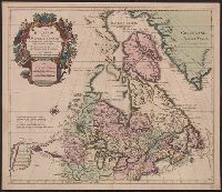
Buache, Philippe, 1700-1773 Liebaux, Henri, engraver L'Isle, Guillaume de, 1675-1726
Published / Created:
1706 [i.e. 1745]
Call Number:
352 1745
Container / Volume:
BRBL_00104
Image Count:
2
Resource Type:
Maps, Atlases & Globes
Description:
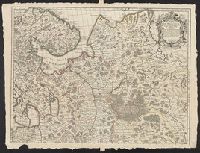
Bar scales given in "verstes, In bottom margin of sheet 2: Ph[ilippe] Buache, p[remier] g[éographe] d[u] R[oy]; d[e] l'A[cadémie] r[oyale] d[es] s[ciences]. Gendre de l'auteur. Avec privilége du 30 av[ril] 1745., and Sheets 54 x 71 cm. or smaller.
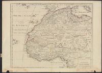
"Avec privil, "The words 'premier geographe du Roi' added in the title ... [indicate] that [a map] could not have been issued before 1718 when [De l'Isle] was appointed to that office"--Tooley, R.V. Guide to maps of Africa, p. 68., and Relief shown pictorially.
Publisher:
chez l'auteur fur le Quai de l'Horloge a l'Aigle d'Or,
Subject (Geographic):
Africa, North--Maps--Early works to 1800 and Africa, West--Maps--Early works to 1800
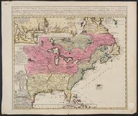
Includes inset of "Les costes de la Louisiane ....", Relief shown pictorially., and Yale's copy annotated in pencil with "circa 1760" on recto and "ca. 1720" on verso.
Publisher:
s.n.?,
Subject (Geographic):
New France--Maps--Early works to 1800 and North America--Maps--Early works to 1800
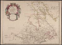
Copy 2: Mounted on linen. Sheet measures 57.3 x 79 cm. Ms. no. on verso: No. 6., Imprint date from Tooley., Includes descriptive text., and Relief shown pictorially.
Publisher:
Chez l'auteur sur le Quai de l'Horloge a l'Aigle d'Or,
1st state of re-engraved, close copy of L'Isle's map of the same title (Kershaw 284)., According to Ke, According to Kershaw, this map is copied with only slight alteration from the Del'Isle map of Canada., Cross collection no. 169., and Relief shown pictorially.
Publisher:
chez Pierre Mortier,
Subject (Geographic):
Canada--Maps--Early works to 1800 and North America--Maps--Early works to 1800
Subject (Name):
L'Isle, Guillaume de, 1675-1726 and Ottens Joachim, 1663-1719
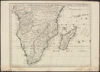
"Avec privilege Janvier 1708.", "The words 'premier geographe du Roi' added in the title ... [indicate] that [a map] could not have been issued before 1718 when [De l'Isle] was appointed to that office"--Tooley, R.V. Guide to maps, and Relief shown pictorially.
Publisher:
chez l'auteur sur le Quai de l'Horloge,
Subject (Geographic):
Africa, Central--Maps--Early works to 1800 and Africa, Southern--Maps--Early works to 1800
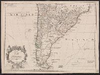
Appears in L'Isle's Atlas de géographie. Paris : Guillaume DeLisle, Quai de l'Horloge, 1731., Or, Relief shown pictorially., Sheet measures 54.9 x 74.6 cm., and Shows routes of Magellan, Sarmiento, Brower, Beauchesne, Sharp, Sr. de la Roche, Halley and Vespucci.
Publisher:
Chez l'auteur sur le Quai de l'Horloge ...,
Subject (Geographic):
South America--Maps--1708-1718 and South America--Maps--Early works to 1800
Subject (Name):
Liebaux, engraver, L'Isle, Guillaume de, 1675-1726. Atlas de géographie, and Simonneau, Charles, 1645-1728
Appears in L'Isle's Atlas de géographie. Paris : Guillaume DeLisle, Quai de l'Horloge, 1731., Imprint of Louis Renard Libraire, Mounted in linen. Sheet measures 51.8 x 69.7 cm., Ornamental cartouche by "C. Simonneau inv. et fecit.", and Relief shown pictorially.
Publisher:
Chez l'auteur sur le Quai de l'Horloge ...,
Subject (Geographic):
South America--Maps--1708-1718 and South America--Maps--Early works to 1800
Subject (Name):
Liebaux, engraver, L'Isle, Guillaume de, 1675-1726. Atlas de géographie, and Simonneau, Charles, 1645-1728
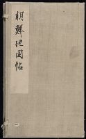
An atlas of Korea. This is an atlas of Chosŏn dynasty, and can be considered a follow-up version of the Tongguk chido (東國地圖), or the Map of Korea, drawn by Chŏng Sang-gi (鄭尚驥, 1678-1752), which has been evaluated as an outstanding accomplishment in the history of cartography. The atlas consists of a complete map of Korea, and eight maps for the provinces. The complete map of Korea is a down-scaled version in smaller size. As to the maps of each province, Kyŏnggi Province and Ch'ungch'ŏng Province were drawn in one piece, while Hamgyŏng Province, larger in area, was rendered in two pieces; northern and southern Hamgyŏng Province. A scale of one hundred ri (里) to one cha (尺) was applied and marked accurately on each of the provincial maps. The introduction of accurate scale to the map was one of the most striking features of Chŏng Sang-gi's Map of Korea. Also noteworthy are the elaborate rendering of the demarcation lines of the northern borders, and the detailed representation of the land and the sea routes, which are also the characteristics of Chŏng Sang-gi's maps. This atlas is presumed to be a copy of one that was produced before 1767 because the town names of Anŭm (安陰) and Sanŭm (山陰) of Kyŏngsang Province are given using earlier names instead of the new names adopted in that year. Other distinguishing features are that Paegyagot (白也串) in the east of Hŭngyang (興陽), Chŏlla Province is represented as an island instead of a promontory, that there is a lake near Sŏgwip'o in Cheju Island, and that the place names are marked on the northern banks across the Amnok River (鴨綠江) and Tuman River (豆滿江), which had previously been left blank. These attest to the fact that this atlas was produced or at least is a copy of one that was produced in between the original version of Chŏng Sang-gi's Map of Korea and its revised version. and 전도와8도의지도를엮음.
Alternative Title:
Chidoch'ŏp, Jido cheop, 지도첩, and 地圖帖, [Late Chosŏn i.e. 18th century].
Description:
In Korean (Hanmun)., Manuscript, in an unidentified hand., and Yale Association of Japan Collection original call number: Db11.
Subject (Topic):
Korean manuscripts and Yale Association of Japan Collection