Skip to search
Skip to main content
Skip to first result
Search
You Searched For
Date
1710 - 1719
Format
cartographic
Date Created
1710 to 1719
New Search
Search Results
Creator:
Published / Created:
ca. 1714]
Call Number:
755 1714B
Container / Volume:
BRBL_00425
Image Count:
1
Resource Type:
Maps, Atlases & Globes
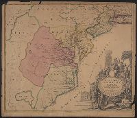
Description:
Also covers Delaware, southern Pennsylvania, New Jersey, western Long Island, southwestern Connecticut, and portions of adjacent areas., Bar scale given in "milliaria Germanica"., Includes ill., Relief shown pictorially. Depths shown by soundings., and Title in L
Publisher:
[Johann Baptist Homann?,
Subject (Geographic):
Atlantic States--Maps--Early works to 1800
Subject (Name):
Homann, Johann Baptist, 1663-1724. Atlas novus
Found in:
Beinecke Rare Book and Manuscript Library > Virginia, Marylandia et Carolina in America septentrionali Brittannorum industria excultae / repraesentatae à Ioh. Bapt. Homann, S.C.M. Geog.
Creator:
Published / Created:
1719
Call Number:
57 1719
Container / Volume:
BRBL_00301
Image Count:
1
Resource Type:
Maps, Atlases & Globes
Description:
From Chatelain's Atlas historique et methodique. Amsterdam : Guedeville, 1719., In top right hand corner: Tom: V. No. 56. Pag: 172., Sheet measures 44.5 x 54 cm, and Six views of Japan on one sheet with text.
Publisher:
Gueudeville,
Subject (Geographic):
Meaco (Japan)--Pictorial works
Subject (Name):
Gueudeville, Nicolas, ca. 1654-ca. 1721
Found in:
Beinecke Rare Book and Manuscript Library > Vue et description de la ville de Meaco, capitale du Japon.
Published / Created:
[17--?]
Call Number:
380 No. 6
Container / Volume:
BRBL_00173
Image Count:
1
Resource Type:
Maps, Atlases & Globes
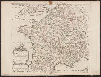
Subject (Geographic):
France--Maps--Early works to 1800
Found in:
Beinecke Rare Book and Manuscript Library > [Ancient France] Gallia Antiqua ... ab Aeg. Robert Geographo.
Published / Created:
17--]
Call Number:
360 No. 4
Container / Volume:
BRBL_00134
Image Count:
1
Resource Type:
Maps, Atlases & Globes
Subject (Geographic):
Germany--Maps--Early works to 1800
Found in:
Beinecke Rare Book and Manuscript Library > [Ancient Germany] Germania Antiqua ... Auctore Robert de Vaugondy Geo ...
Published / Created:
[17--]
Call Number:
360 No. 1
Container / Volume:
BRBL_00134
Image Count:
1
Resource Type:
Maps, Atlases & Globes
Subject (Geographic):
Germany--Maps--Early works to 1800
Found in:
Beinecke Rare Book and Manuscript Library > [Ancient Germany] Germania Antiqua. Engraved by S.J. Neele.
Published / Created:
[17--]
Call Number:
530 No. 8
Container / Volume:
BRBL_00287
Image Count:
1
Resource Type:
Maps, Atlases & Globes
Subject (Geographic):
Middle East--Maps--Early works to 1800
Found in:
Beinecke Rare Book and Manuscript Library > [Ancient Near East] Alexandri Magni Macedonis expeditio [334 B.C.].
Published / Created:
[17--]
Call Number:
530 No. 10
Container / Volume:
BRBL_00287
Image Count:
1
Resource Type:
Maps, Atlases & Globes
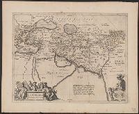
Description:
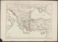
Eastern Empire.
Subject (Geographic):
Middle East--Maps--Early works to 1800
Found in:
Beinecke Rare Book and Manuscript Library > [Ancient Near East] Imperii Orientalis et Circumjacentium Regionum Sub Constantino Porphyrogenito ... G. Delisle.
Published / Created:
[17--]
Call Number:
530 No. 5
Container / Volume:
BRBL_00287
Image Count:
1
Resource Type:
Maps, Atlases & Globes
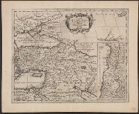
Description:
Inset: Palestine.
Subject (Geographic):
Middle East--Maps--Early works to 1800
Found in:
Beinecke Rare Book and Manuscript Library > [Ancient Near East] Lumen Historiarum per Orientem ...
Published / Created:
[17--]
Call Number:
530 No. 11
Container / Volume:
BRBL_00287
Image Count:
1
Resource Type:
Maps, Atlases & Globes
Description:
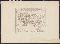
Eastern Empire.
Subject (Geographic):
Middle East--Maps--Early works to 1800
Found in:
Beinecke Rare Book and Manuscript Library > [Ancient Near East] Orbis Romani descriptio seu Divisio per The Mata sub Imperatoribus Constantinopolitanis post Heraclii ... G. Del'Isle ...
Published / Created:
1715
Call Number:
530 No. 4
Container / Volume:
BRBL_00287
Image Count:
1
Resource Type:
Maps, Atlases & Globes
Subject (Geographic):
Middle East--Maps--Early works to 1800
Found in:
Beinecke Rare Book and Manuscript Library > [Ancient Near East] Tabula Geographica Provinciarumet Urbium Colonia Romana ...
Branch:v1.61.6 ,Deployed:2024-06-12T09:55:36-04:00