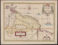
Color: pen with coasts outlined in grey watercolor, gold lettering., Invoice from H.P. Kraus Rare Books., and Lower Miss. Valley before New Orleans. 15 Indian Villages and French forts.
Subject (Geographic):
Mississippi River--Maps, Manuscript--Early works to 1800
2nd state of 2 known states (Pedley 194)., Karpinski-von Wieser collection., Lower left corner, below title cartouche: signed "Groux"., and On verso: numbered "10" in upper right corner; stamped "Yale UL" and "Yale University Library Karpinski-von Wieser Map Col
Publisher:
chez Delamarche,
Subject (Geographic):
Greece--Historical geography--Maps--Early works to 1800 and Greece--Maps--Early works to 1800
Subject (Name):
Delamarche, Charles François, 1740-1817. publisher, Groux, Charles Jacques, engraver, and Robert de Vaugondy, Didier, 1723-1786. Atlas universel. 17??
Subject (Topic):
Historical geography--Greece--Maps--Early works to 1800
Gviana siue Amazonvm regio and Gviana sive Amazonvm regio
Description:
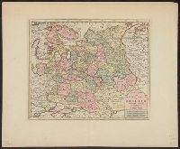
Bar scales in "Milliaria Germanica communia" and "Milliaria Gallica communia.", Hand col. Mounted on linen. Sheet measures 42.5 x 53.5 cm., and Relief shown pictorially.
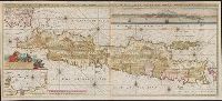
Also shows p, Includes text, col. view of Jakarta, inset of Jakarta, and some cities are marked with gilt., Library copy joined to form 1 sheet., Pars occidentalis --, Prime meridian: Ferro., and Title and notes in Latin. Place-names and scale statements in Dutch.
Publisher:
by Gerard van Keulen aan de Nieuwe brug met previlegie,
Subject (Geographic):
Jakarta (Indonesia)--Maps--Early works to 1800 and Java (Indonesia)--Maps--Early works to 1800
Backed with paper. Ms. no. "78" in upper right-hand corner. Sheet measures 53.6 x 62.8 cm. No. 72 of 87 maps bound together., Includes four bar scales., and Relief shown pictorially.
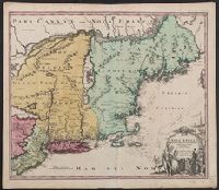
"Cum privilegio Sac. Caes. Maj.", Map features New Jersey, New York and New England., Relief represented pictorially., and Sheet measures 53.6 x 62.3 cm. Ms. no. on verso: 141. Title in ms. on verso. Franklin Collection no. 131 1759-2.
Publisher:
[s.n.,
Subject (Geographic):
New England--Maps--Early works to 1800, New Jersey--Maps--Early works to 1800, and New York--Maps--Early works to 1800
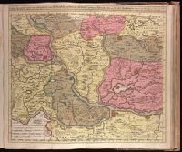
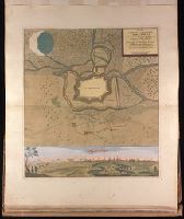
Backed with paper. Ms. no. "81" in lower right corner. Sheet measures 62.2 x 53.7 cm. No. 75 of 87 maps bound together. and Includes bird's-eye view of Temeswar at bottom.
Cross collection no. 28., Includes text, two celestial insets, two insets of solstices, two panoramic views, and illustrations., and Relief shown pictorially.