Geographical, historical, political, philosophical and mechanical essays : the first, containing an
Image Count:
1
Resource Type:
Maps, Atlases & Globes
Description:
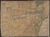
This second issue of the second edition includes the original map with title: A general map of the middle British colonies in America; viz. Virginia, Ma`riland, De`laware, Pensilvania, New-Jersey, New-York, Connecticut, and Rhode Island: of Aquanishuonigy
Subject (Geographic):
Erie, Lake., Middle Atlantic States--Maps., Ohio River Valley--Maps., and Ontario, Lake (N.Y. and Ont.)
Collection Created:
Philadelphia: Printed by B. Franklin, and D. Hall., MDCCLV [1755]
Hand colored., Relief shown pictorially., Shows "West longitude from London" and "from Philadelphia.", and Single sheet, uncolored, mounted on linen. Dimensions: 48 x 65 cm. Recto: Stamped "Yale Horace Brown 1900S".
Publisher:
Sold by T. Jefferys,
Subject (Geographic):
North America--Maps--Early works to 1800 and Northeastern States--Maps--Early works to 1800
Subject (Name):
Evans, Lewis, 1700?-1756, Jefferys, Thomas, d. 1771, and Mellon, Paul--Bookplate
Evans, Lewis, 1700?-1756 Gibson, J. (John), creator Jefferys, Thomas, d. 1771
Published / Created:
1758
Call Number:
2003 Folio 85
Image Count:
1
Alternative Title:
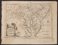
Middle British colonies
Description:
Available also through the Library of Congress Web site as a raster image., BEIN 2003 Folio 85: No. 17 of 45 maps bound together with binder's spine title: Atlas of America; ms. table of contents. Bookplate: Robinson. Bookplate of Paul Mellon., carefully copied from the original published at Philadelphia, by Mr. Lewis Evans 1755, with some improvements by I. Gibson., Hand colored., LC Maps of North America, 1750-1789,, Relief shown pictorially., Scale [ca. 1:2,250,000]., and Shows West longitude from London and from Philadelphia.
Publisher:
Sold by T. Jefferys
Subject (Geographic):
North America -- Maps -- Early works to 1800 and Northeastern States -- Maps -- Early works to 1800
"Sold by R. Dodsley in Pall-Mall, London, & by the author in Philadelphia." and Includes inscription to "Thomas Pownall, Esqr.," numerous notes, especially concerning inland water communications and natural reources, 3 distance charts, and inset of "A sketch
Subject (Geographic):
Northeastern States--Maps--Early works to 1800
Subject (Name):
Dodsley, Robert, 1703-1764, Pownall, Thomas, 1722-1805, and Turner, James, d. 1759
"For the Lond. Mag.", From the London Magazine (August 1757), p. 376., and Sheet measures 20.5 x 26.4 cm. Cross Collection no. 206.
Publisher:
Printed for R. Baldwin in Pater Noster Row,
Subject (Geographic):
Chesapeake Bay Region (Md. and Va.)--Maps--Early works to 1800, Delaware--Maps--Early works to 1800, New Jersey--Maps--Early works to 1800, and Pennsylvania--Maps--Early works to 1800
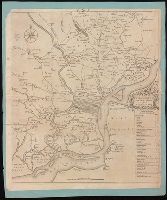
Coordinates not present on map and are approximated., From Gentleman's Magazine, vol. 23, 1753 p. 373., Includes table of distances "The distances of particular places in this map, from the court house.", and Manuscript "(G)" at top of sheet. Mounted on blue paper.
Publisher:
[publisher not identified],
Subject (Geographic):
Philadelphia (Pa.)--Maps--Early works to 1800. and Philadelphia Region--Maps--Early works to 1800.
Subject (Name):
Heap, George, active 1715-1760
Subject (Topic):
Landowners--Pennsylvania Region--Philadelphia--Maps--Early works to 1800. and Landowners--Pennsylvania--Philadelphia--Maps--Early works to 1800.