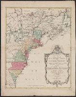
Appears in Matthaeus Seutter's Grosser atlas., Neat lines measure 60.1 x 49.2 cm. on sheet 68.4 x 54.1 cm. Cross Collection no. 196., and Relief shown pictorially.
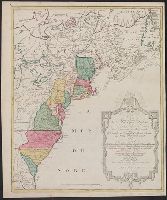
Appears in Matthaeus Seutter's Grosser atlas., Neat lines measure 69.1 x 49.2 cm. on sheet 70 x 55.2 cm. Ms. title on verso. Stamp on verso: Yale Horace Brown, 1900S., and Relief shown pictorially.
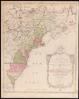
Appears in Matthaeus Seutter's Grosser atlas., Relief shown pictorially., and Sheet measures 62.4 x 52.7 cm. Ms. no. on verso: 63. Franklin Collection.
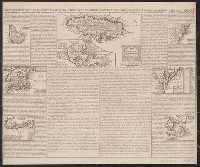
Carte de la Jamaique [with inset of Gulf of Mexico and Caribbean Area] -- Ile des Barbades -- Nouve, Mounted on linen. Sheet measures 44.6 x 53.3 cm. Cross Collection no. 153., Probably from Chatelain's Atlas historique, 1705-1720., and Relief shown pictorially.
Robert de Vaugondy, Gilles, 1688-1766, cartographer.
Call Number:
73 1785
Image Count:
1
Resource Type:
Maps, Atlases & Globes
Alternative Title:
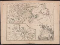
Partie de l'Amérique septent[rionale] qui comprend la Nouvelle France ou le Canada
Description:
Decorative title cartouche by Graux., Fourth state with date in cartouce removed., From the author's Atlas universel., Inset of "Supplement pour les lacs du Canada" (scale approximately 1:5,500,000)., Relief shown pictorially., and Watermark.
Subject (Geographic):
Great Lakes Region (NorthAmerica
Subject (Name):
Robert de Vaugondy, Gilles, 1688-1766. Atlas universel.
Partie de l'Amérique septent[rionale] qui comprend la Nouvelle France ou le Canada
Description:
"Avec privilege 1755.", "C. Haussard sculp.", "Wm. Inglis Morse Collection" -- on recto in upper right corner. Stamp on verso: Canada. No. on verso: 103., From the author's Atlas universel. 1757[-1758]., Inset of "Supplement pour les lacs du Canada." Scale [ca. 1:5,500,000]., Relief shown pictorially., Second state, with "I. Charlton" in James Bay named and the location and orientation of "F. de la Presqu'íle" changed., and Watermark.
Publisher:
s.n.,
Subject (Geographic):
Great Lakes Region (NorthAmerica
Subject (Name):
George Washington's American Atlas., Haussard, Catherine, engraver., Morse, William Inglis,--b. 1874--Stamp., Robert de Vaugondy, Gilles, 1688-1766. Atlas universel., and Washington, George,--1732-1799--Ownership.
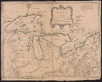
"Longitude occidentale du meridien de Paris"., Appears in the Homann Erben Atlas compendiarivs. 1752 [i.e. 1755]., Hand colored. Stamp: Yale Horace Brown 1900S., Relief shown pictorially., and Shows Great Lakes region.
Covers the area from Lake Superior to Kaskaskia and from Delaware Bay to the Mississippi River., Relief shown pictorially., Shows a few towns, missions, forts, Indian villages and tribal territory, rivers and lakes, portages, and early place-names., and Watermark.