Skip to search
Skip to main content
Skip to first result
Search
You Searched For
Format
cartographic
New Search
Search Results
Call Number:
Zc52 833hob
Collection Title:
Texas
Image Count:
1
Resource Type:
Maps, Atlases & Globes
Found in:
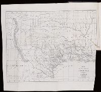
Beinecke Rare Book and Manuscript Library > Map of the state of Coahuila and Texas
Creator:
Call Number:
ZZc70 752L
Collection Title:
Explication de la carte des nouvelles decouvertes au nord de la mer du Sud; par m. de Lisle ...
Image Count:
1
Resource Type:
Maps, Atlases & Globes
Found in:
Beinecke Rare Book and Manuscript Library > Carte de nouvelles decouvertes au nord de la mer du Sud, tant a lest de la Siberie et du Kamtchatka, qua louest de la Nouvelle France
Creator:
Call Number:
1973 Folio 103
Collection Title:
De Nieuwe groote lichtende zee-fakkel ...
Image Count:
1
Resource Type:
Maps, Atlases & Globes
Found in:
Beinecke Rare Book and Manuscript Library > De Oostin-dische zee / Het Eyland Mayota
Creator:
Call Number:
1973 Folio 103
Collection Title:
De Nieuwe groote lichtende zee-fakkel ...
Image Count:
1
Resource Type:
Maps, Atlases & Globes
Found in:
Beinecke Rare Book and Manuscript Library > Des rivier legt op de Hoogte von 18 Graaden Zuyder Breedte aan het Land van de Megosie ter Kuste van Quama / Noord kust van't eyland ...
Creator:
Call Number:
1973 Folio 103
Collection Title:
De Nieuwe groote lichtende zee-fakkel ...
Image Count:
1
Resource Type:
Maps, Atlases & Globes
Found in:
Beinecke Rare Book and Manuscript Library > Madagascar
Call Number:
1971 Folio 602
Collection Title:
Carte topographique de lEgypte et de plusiers parties des pays limitrophes; levee pendant
Image Count:
1
Resource Type:
Maps, Atlases & Globes
Found in:
Beinecke Rare Book and Manuscript Library > Le Caire, Belbeis. pl. 24.
Call Number:
1971 Folio 602
Collection Title:
Carte topographique de lEgypte et de plusiers parties des pays limitrophes; levee pendant
Image Count:
1
Resource Type:
Maps, Atlases & Globes
Found in:
Beinecke Rare Book and Manuscript Library > [Map of Egypt, the Red Sea, Palestine, the Sinai Peninsula and other Middle Eastern landmarks]. pl. 2.
Call Number:
1971 Folio 602
Collection Title:
Carte topographique de lEgypte et de plusiers parties des pays limitrophes; levee pendant
Image Count:
1
Resource Type:
Maps, Atlases & Globes
Found in:
Beinecke Rare Book and Manuscript Library > Tableau d'assembalge pour la carte topographique de l'Egypte en 47 feuilles et pour la carte geographique en 3 feuilles.
Call Number:
1977 Folio 78
Collection Title:
A New and accurate chart of the West-India Islands and coast, with the gulf passage through the New
Image Count:
1
Resource Type:
Maps, Atlases & Globes
Found in:
Beinecke Rare Book and Manuscript Library > A plan of Fort St. Louis harbour on the south side of Hispaniola, pl. 31.
Creator:
Call Number:
1977 Folio 78
Collection Title:
A New and accurate chart of the West-India Islands and coast, with the gulf passage through the New
Image Count:
1
Resource Type:
Maps, Atlases & Globes
Found in:
Beinecke Rare Book and Manuscript Library > A new general chart of the West Indies from the latest marine journals and surveys. Regulated and ascertained by astronomical observations
Creator:
Call Number:
C6 033c
Collection Title:
The natural and civil history of the French dominions in North and South America : with an
Image Count:
1
Resource Type:
Maps, Atlases & Globes
Found in:
Beinecke Rare Book and Manuscript Library > An authentic plan of the town and harbour of Cap Francois in the isle of St. Domingo. By Thomas Jefferys geographer to his Royal Highness the Prince of Wales
Creator:
Call Number:
C6 033c
Collection Title:
The natural and civil history of the French dominions in North and South America : with an
Image Count:
1
Resource Type:
Maps, Atlases & Globes
Found in:
Beinecke Rare Book and Manuscript Library > The island of Hispaniola called by the French St. Domingo. Subject to France and Spain. from the best authorities by Thomas Jeffreys, geographer to his Royal Highness the Prince of Wales
Call Number:
1972 Folio 31
Collection Title:
El teniente general D. Jose Manuel de Goyeneche, primer conde de Guaqui; apuntes y datos para la
Image Count:
1
Resource Type:
Maps, Atlases & Globes
Found in:
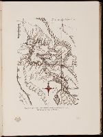
Beinecke Rare Book and Manuscript Library > Region del lago Titicaca. Mapa mandado levantar por el General Goyeneche. (Del Archivo del Condo de Guaqui.)
Creator:
Call Number:
1977 Folio 96
Collection Title:
The West-India atlas: or, A compendious description of the West-Indies: illustrated with forty
Image Count:
1
Resource Type:
Maps, Atlases & Globes
Found in:
Beinecke Rare Book and Manuscript Library > The harbour of Bluefields.
Creator:
Call Number:
1973 Folio 17
Collection Title:
Atlas francois, contenant les cartes geographiques dans les quelles sont tres exactement remarquez
Image Count:
1
Resource Type:
Maps, Atlases & Globes
Found in:
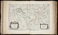
Beinecke Rare Book and Manuscript Library > La Generalite de Paris divisee ens ses eslections
Creator:
Call Number:
Ee +633gb
Collection Title:
The voyages and travells of the ambassadors sent by Frederick, duke of Holstein, to the great Duke
Image Count:
1
Resource Type:
Maps, Atlases & Globes
Found in:
Beinecke Rare Book and Manuscript Library > The course of the great River Wolga
Creator:
Call Number:
1979 Folio 55
Collection Title:
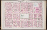
Atlas of the city of New York, Manhattan Island. From actual surveys and official plans, by George
Image Count:
1
Resource Type:
Maps, Atlases & Globes
Found in:
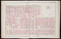
Beinecke Rare Book and Manuscript Library > Part of ward 19 New York City part of section 5, plate 22
Creator:
Call Number:
1979 Folio 55
Collection Title:
Atlas of the city of New York, Manhattan Island. From actual surveys and official plans, by George
Image Count:
1
Resource Type:
Maps, Atlases & Globes
Found in:
Beinecke Rare Book and Manuscript Library > Part of sections 34 & 5, part of wards 19, 20, 21, & 22, plate 20
Call Number:
1977 +392
Collection Title:
A survey of the cities of London and Westminster : containing the original, antiquity, increase
Image Count:
1
Resource Type:
Maps, Atlases & Globes
Found in:
Beinecke Rare Book and Manuscript Library > A mapp of the parishes of St. Clements Danes, St. Mary Savoy; with the Rolls Liberty and Lincolns Inn, taken from the last survey with corrections and additions
Call Number:
1977 +392
Collection Title:
A survey of the cities of London and Westminster : containing the original, antiquity, increase
Image Count:
1
Resource Type:
Maps, Atlases & Globes
Found in:
Beinecke Rare Book and Manuscript Library > Cow Cross being St. Sepulcher's parish without and the Charter House taken from the last survey with corrections
Call Number:
1977 +392
Collection Title:
A survey of the cities of London and Westminster : containing the original, antiquity, increase
Image Count:
1
Resource Type:
Maps, Atlases & Globes
Found in:
Beinecke Rare Book and Manuscript Library > Shoreditch, Norton Folgate, and Crepple Gate without, taken from the last survey with corrections
Call Number:
1977 +392
Collection Title:
A survey of the cities of London and Westminster : containing the original, antiquity, increase
Image Count:
1
Resource Type:
Maps, Atlases & Globes
Found in:
Beinecke Rare Book and Manuscript Library > Spittle Fields and places adjacent taken from the last survey with corrections
Call Number:
1977 +392
Collection Title:
A survey of the cities of London and Westminster : containing the original, antiquity, increase
Image Count:
1
Resource Type:
Maps, Atlases & Globes
Found in:
Beinecke Rare Book and Manuscript Library > A map of the parish of St. Dustans Stepney and Stebunheath divided into hamlets
Call Number:
1977 +392
Collection Title:
A survey of the cities of London and Westminster : containing the original, antiquity, increase
Image Count:
1
Resource Type:
Maps, Atlases & Globes
Found in:
Beinecke Rare Book and Manuscript Library > The parish of St. Johns Wapping
Call Number:
1977 +392
Collection Title:
A survey of the cities of London and Westminster : containing the original, antiquity, increase
Image Count:
1
Resource Type:
Maps, Atlases & Globes
Found in:
Beinecke Rare Book and Manuscript Library > A map of the parish if St. Katherines by the Tower
Call Number:
1977 +392
Collection Title:
A survey of the cities of London and Westminster : containing the original, antiquity, increase
Image Count:
1
Resource Type:
Maps, Atlases & Globes
Found in:
Beinecke Rare Book and Manuscript Library > A mapp of the parishes of St. Saviours Southwark and St. Georges taken from the last survey with corrections
Call Number:
1977 +392
Collection Title:
A survey of the cities of London and Westminster : containing the original, antiquity, increase
Image Count:
1
Resource Type:
Maps, Atlases & Globes
Found in:
Beinecke Rare Book and Manuscript Library > St. Olave and St. Mary Magdalen Bermondsey Southwark, taken from the last survey with corrections
Call Number:
1977 +392
Collection Title:
A survey of the cities of London and Westminster : containing the original, antiquity, increase
Image Count:
1
Resource Type:
Maps, Atlases & Globes
Found in:
Beinecke Rare Book and Manuscript Library > Farington Ward without, with its divisions into parishes, taken from the last survey with corrections & amendments
Call Number:
1977 +392
Collection Title:
A survey of the cities of London and Westminster : containing the original, antiquity, increase
Image Count:
1
Resource Type:
Maps, Atlases & Globes
Found in:
Beinecke Rare Book and Manuscript Library > The Wards of Farington within and Baynards Castle with its divisions into parishes taken from the last survey with corrections
Call Number:
1977 +392
Collection Title:
A survey of the cities of London and Westminster : containing the original, antiquity, increase
Image Count:
1
Resource Type:
Maps, Atlases & Globes
Found in:
Beinecke Rare Book and Manuscript Library > Coleman Street Ward and Bashishaw Ward taken from the last survey, with corrections and additions
Call Number:
1977 +392
Collection Title:
A survey of the cities of London and Westminster : containing the original, antiquity, increase
Image Count:
1
Found in:
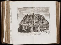
Beinecke Rare Book and Manuscript Library > The Prospect of Guild Hall
Call Number:
1977 +392
Collection Title:
A survey of the cities of London and Westminster : containing the original, antiquity, increase
Image Count:
1
Resource Type:
Maps, Atlases & Globes
Found in:
Beinecke Rare Book and Manuscript Library > Cheape Ward with its division into parishes, taken from the last survey, with corrections and additions
Call Number:
1977 +392
Collection Title:
A survey of the cities of London and Westminster : containing the original, antiquity, increase
Image Count:
1
Resource Type:
Maps, Atlases & Globes
Found in:
Beinecke Rare Book and Manuscript Library > Bread Street Ward and Cordwainer Ward with it's division into parishes taken from the last survey
Call Number:
1977 +392
Collection Title:
A survey of the cities of London and Westminster : containing the original, antiquity, increase
Image Count:
1
Resource Type:
Maps, Atlases & Globes
Found in:
Beinecke Rare Book and Manuscript Library > Queen Hith Ward and Vintry Ward with their division into parishes taken from the last surveys
Call Number:
1977 +392
Collection Title:
A survey of the cities of London and Westminster : containing the original, antiquity, increase
Image Count:
1
Resource Type:
Maps, Atlases & Globes
Found in:
Beinecke Rare Book and Manuscript Library > Walbrook Ward and Dow Gate Ward with its division into parishes taken from the last surveys
Call Number:
1977 +392
Collection Title:
A survey of the cities of London and Westminster : containing the original, antiquity, increase
Image Count:
1
Resource Type:
Maps, Atlases & Globes
Found in:
Beinecke Rare Book and Manuscript Library > Candlewick Ward with its division into parishes. Corrected from the last survey
Call Number:
1977 +392
Collection Title:
A survey of the cities of London and Westminster : containing the original, antiquity, increase
Image Count:
1
Found in:
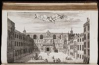
Beinecke Rare Book and Manuscript Library > The Royal Exchange of London
Call Number:
1977 +392
Collection Title:
A survey of the cities of London and Westminster : containing the original, antiquity, increase
Image Count:
1
Resource Type:
Maps, Atlases & Globes
Found in:
Beinecke Rare Book and Manuscript Library > Cornhill Ward with its division into parishes, taken from the last survey &c
Call Number:
1977 +392
Collection Title:
A survey of the cities of London and Westminster : containing the original, antiquity, increase
Image Count:
1
Resource Type:
Maps, Atlases & Globes
Found in:
Beinecke Rare Book and Manuscript Library > Bishop Gate Street Ward taken from the last survey and corrected
Call Number:
1977 +392
Collection Title:
A survey of the cities of London and Westminster : containing the original, antiquity, increase
Image Count:
1
Resource Type:
Maps, Atlases & Globes
Found in:
Beinecke Rare Book and Manuscript Library > Part of Aldgate Ward
Call Number:
1977 +392
Collection Title:
A survey of the cities of London and Westminster : containing the original, antiquity, increase
Image Count:
1
Resource Type:
Maps, Atlases & Globes
Found in:
Beinecke Rare Book and Manuscript Library > Aldgate Ward with its division into parishes. Taken from the last survey, with corrections & additions
Call Number:
1977 +392
Collection Title:
A survey of the cities of London and Westminster : containing the original, antiquity, increase
Image Count:
1
Resource Type:
Maps, Atlases & Globes
Found in:
Beinecke Rare Book and Manuscript Library > The Custom House
Call Number:
1977 +392
Collection Title:
A survey of the cities of London and Westminster : containing the original, antiquity, increase
Image Count:
1
Resource Type:
Maps, Atlases & Globes
Found in:
Beinecke Rare Book and Manuscript Library > Portsoken ward being part of the parish of St. Buttolphs Aldgate, taken from the last survey, with corrections and additions
Call Number:
Gfp94 gf525j
Collection Title:
Geographiae vniversae ... opvs ... habentur Cl. Ptolemaei ... Geographicae enarrationis libri octo
Image Count:
1
Resource Type:
Maps, Atlases & Globes
Found in:
Beinecke Rare Book and Manuscript Library > Vniversi orbis descriptop as vsvm navigantivm
Call Number:
1977 1341
Collection Title:
Geographiae vniversae opvs habentur Cl. Ptolemaei ... Geographicae enarationis libri octo [tr. by W
Image Count:
1
Resource Type:
Maps, Atlases & Globes
Found in:
Beinecke Rare Book and Manuscript Library > Vniversi orbis descriptio ad vsvm navigantivm
Call Number:
1977 +435
Collection Title:
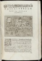
Geografia; cioè, Descrittione vniversale della terra. Partita in due volumi, nel primo de' quali si
Image Count:
1
Resource Type:
Maps, Atlases & Globes
Found in:
Beinecke Rare Book and Manuscript Library > [Geographia. Italian]
Call Number:
1977 +435
Collection Title:
Geografia; cioè, Descrittione vniversale della terra. Partita in due volumi, nel primo de' quali si
Image Count:
1
Resource Type:
Maps, Atlases & Globes
Found in:
Beinecke Rare Book and Manuscript Library > [Geographia. Italian]
Call Number:
1975 +1
Collection Title:
L'isole piv famose del mondo descritte da Thomaso Porcacchi da Castiglione Arretino e intagliate da
Image Count:
1
Resource Type:
Maps, Atlases & Globes
Found in:
Beinecke Rare Book and Manuscript Library > Descrittione dell' isola Cuba
Call Number:
1975 +1
Collection Title:
L'isole piv famose del mondo descritte da Thomaso Porcacchi da Castiglione Arretino e intagliate da
Image Count:
1
Resource Type:
Maps, Atlases & Globes
Found in:
Beinecke Rare Book and Manuscript Library > Descrittione dell'isola Spagnuola
Call Number:
1977 +379
Collection Title:
Geografia; cioè, Descrittione vniversale della terra. Partita in due volumi, nel primo de' quali si
Image Count:
1
Resource Type:
Maps, Atlases & Globes
Found in:
Beinecke Rare Book and Manuscript Library > [Geographia. Italian]
Call Number:
Gfp94 +Gi597
Collection Title:
Geografia; cioè, Descrittione vniversale della terra. Partita in due volumi, nel primo de' quali si
Image Count:
1
Resource Type:
Maps, Atlases & Globes
Found in:
Beinecke Rare Book and Manuscript Library > [Geographia. Italian]
Call Number:
1976 +310
Collection Title:
L'isole piv famose del mondo descritte da Thomaso Porcacchi da Castiglione Arretino e intagliate da
Image Count:
1
Resource Type:
Maps, Atlases & Globes
Found in:
Beinecke Rare Book and Manuscript Library > Descrittione dell'isola Cuba
Call Number:
1976 +310
Collection Title:
L'isole piv famose del mondo descritte da Thomaso Porcacchi da Castiglione Arretino e intagliate da
Image Count:
1
Resource Type:
Maps, Atlases & Globes
Found in:
Beinecke Rare Book and Manuscript Library > Descrittione dell'isola Spagnuola
Call Number:
1974 +188
Collection Title:
L'isole piv famose del mondo descritte da Thomaso Porcacchi da Castiglione Arretino e intagliate da
Image Count:
1
Resource Type:
Maps, Atlases & Globes
Found in:
Beinecke Rare Book and Manuscript Library > Descrittione dell' isola Cuba
Call Number:
1974 +188
Collection Title:
L'isole piv famose del mondo descritte da Thomaso Porcacchi da Castiglione Arretino e intagliate da
Image Count:
1
Resource Type:
Maps, Atlases & Globes
Found in:
Beinecke Rare Book and Manuscript Library > Descrittione dell' isola Spagnuola
Call Number:
1985 +31
Collection Title:
L'isole piu famose del mondo / descritte da Thomaso Porcacchi da Castiglione Arretino e intagliate
Image Count:
1
Resource Type:
Maps, Atlases & Globes
Found in:
Beinecke Rare Book and Manuscript Library > Descrittione dell'isola Cuba, che dal Colombo fu scoperta insieme con la Spagnuloa
Call Number:
1985 +31
Collection Title:
L'isole piu famose del mondo / descritte da Thomaso Porcacchi da Castiglione Arretino e intagliate
Image Count:
1
Resource Type:
Maps, Atlases & Globes
Found in:
Beinecke Rare Book and Manuscript Library > Descrittione dell'isola Spagnuola prima iso la scoperta dal Colombo
Call Number:
1977 +246
Collection Title:
Geografia; cioè, Descrittione vniversale della terra. Partita in due volumi, nel primo de' quali si
Image Count:
1
Resource Type:
Maps, Atlases & Globes
Found in:
Beinecke Rare Book and Manuscript Library > Descrittione di tvtto'l mondo, secondo la prattica de Marinari. Vniversi orbis descriptio ad vsvm navigantivm
Published / Created:
undated
Call Number:
WA MSS S-2962
Collection Title:
Northern Pacific Railway Company maps and drawings
Container / Volume:
3 (Roll) | Map 24
Image Count:
1
Resource Type:
Maps, Atlases & Globes
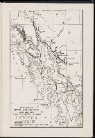
Found in:
Beinecke Rare Book and Manuscript Library > (MONTANA & IDAHO) [Anon.] [Untitled map of far northwestern Montana and a part of the Idaho panhandle.]
Published / Created:
undated
Call Number:
WA MSS S-2962
Collection Title:
Northern Pacific Railway Company maps and drawings
Container / Volume:
Box 1 | Map 36
Image Count:
1
Resource Type:
Maps, Atlases & Globes
Found in:
Beinecke Rare Book and Manuscript Library > (MONTANA) [Anon.] [Untitled map of a part of north central Montana.]
Published / Created:
undated
Call Number:
WA MSS S-2962
Collection Title:
Northern Pacific Railway Company maps and drawings
Container / Volume:
Box 1 | Map 11
Image Count:
1
Resource Type:
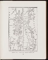
Maps, Atlases & Globes
Found in:
Beinecke Rare Book and Manuscript Library > (IDAHO & WASHINGTON) [Anon.] [Untitled map of northwestern Idaho and northeastern Washington].
Creator:
Call Number:
WA Prints 157
Container / Volume:
Report upon United States Geographical surveys west of the one hundredth meridian in charge of First Lieut. Geo. M. Wheeler ... Vol. 1. Geographical report (Washington, Govt. Print. Off., 1875).
Image Count:
1
Found in:
Beinecke Rare Book and Manuscript Library > U.S. Geographical surveys west of the 100th meridian. Vol. I Geographical report. North American by Zaltieri, 1566
Creator:
Call Number:
WA Prints 156
Container / Volume:
Report upon United States Geographical surveys west of the one hundredth meridian in charge of First Lieut. Geo. M. Wheeler ... Vol. 1. Geographical report (Washington, Govt. Print. Off., 1875).
Image Count:
1
Found in:
Beinecke Rare Book and Manuscript Library > U.S. Geographical surveys west of the 100th meridian. Vol. I Geographical report. From map of North America by Abrahamus Ortelius, 1589. (reduced) [and] America from a globe in Frankfurt, about 1520. (reduced)
Call Number:
1977 Folio 78
Collection Title:
A New and accurate chart of the West-India Islands and coast, with the gulf passage through the New
Image Count:
1
Resource Type:
Maps, Atlases & Globes
Found in:
Beinecke Rare Book and Manuscript Library > A plan of Monte-Christe Bay with the Seven Brothers on the north coast of St. Domingo, pl. 38
Call Number:
1977 Folio 78
Collection Title:
A New and accurate chart of the West-India Islands and coast, with the gulf passage through the New
Image Count:
1
Resource Type:
Maps, Atlases & Globes
Found in:
Beinecke Rare Book and Manuscript Library > A plan of the road of Port Paix in the island of Hispaniola, pl. 35.
Creator:
Call Number:
1998 995
Collection Title:
Voyage au pole sud et dans l'Oceanie sur les corvettes l'Astrolabe et la Zelee : execute par ordre
Image Count:
1
Found in:
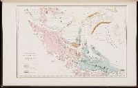
Beinecke Rare Book and Manuscript Library > Carte geologique de la Patagonie et de la terre de feu
Creator:
Call Number:
1976 Folio 139
Collection Title:
The English pilot: describing the sea-coasts, capes, head-lands, soundings, sands, shoals, rocks
Image Count:
1
Found in:
Beinecke Rare Book and Manuscript Library > A large description of the two chanells in the River Dwina goeing up to the citty of Archangel by John Seller
Call Number:
CC68 21
Collection Title:
Views of ancient monuments in Central America : Chiapas and Yucatan / by F. Catherwood ...
Image Count:
1
Found in:
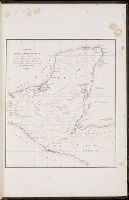
Beinecke Rare Book and Manuscript Library > Outline map of Central America and Yucatan showing the situation of the ruined cities & monuments
Call Number:
1995 Folio 13
Collection Title:
Monuments anciens du Mexique; Palenqu et autres ruines de l'ancienne civilisation du Mexique
Image Count:
1
Found in:
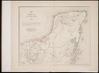
Beinecke Rare Book and Manuscript Library > Carte du Yucatan et des regions voisines
Call Number:
1977 +392
Collection Title:
A survey of the cities of London and Westminster : containing the original, antiquity, increase
Image Count:
1
Found in:
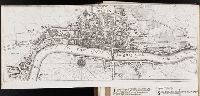
Beinecke Rare Book and Manuscript Library > The city of London as in Q Elisabeth's time
Call Number:
1993 +44
Collection Title:
Topographia provinciarum austriacaru, Austriæ, Striæ, Carinthiæ, Carniolæ, Tyrolis. etc.: das ist
Image Count:
1
Found in:
Beinecke Rare Book and Manuscript Library > [Topographia provinciarum Austriacarum]
Call Number:
Zc56 859so
Collection Title:
Charter and by-laws of the Sopori Land and Mining Company, incorporated by the state of Rhode
Image Count:
1
Resource Type:
Maps, Atlases & Globes
Found in:
Beinecke Rare Book and Manuscript Library > Map of Arizona or the Gadsen Purchase with the position of its silver mines as now worked 1859
Call Number:
Zc50 +601hec
Collection Title:
Historia general de los hechos de los castellanos en las islas i tierra firme del mar oceano
Image Count:
1
Resource Type:
Maps, Atlases & Globes
Found in:
Beinecke Rare Book and Manuscript Library > Descripcion de la l'audiencia del Nuevo Reino
Call Number:
Zc50 +601hec
Collection Title:
Historia general de los hechos de los castellanos en las islas i tierra firme del mar oceano
Image Count:
1
Resource Type:
Maps, Atlases & Globes
Found in:
Beinecke Rare Book and Manuscript Library > Descripcion de la l'audiencia de Panama
Call Number:
1972 515
Collection Title:
Premier voyage autour du monde / par le Chevr. Pigafetta, sur l'escadre de Magellan, pendant les
Image Count:
1
Resource Type:
Maps, Atlases & Globes
Found in:
Beinecke Rare Book and Manuscript Library > Voyage de Pigafetta
Call Number:
1983 Folio 49
Collection Title:
Atlas françois, contenant les cartes geographiques dans les quelles sont tres exactement remarquez
Image Count:
1
Resource Type:
Maps, Atlases & Globes
Found in:
Beinecke Rare Book and Manuscript Library > Provinces-Unies des pays-bas ...
Creator:
Call Number:
Zc49 859pa
Collection Title:
Pacific Railroad of Missouri, the old established and most reliable route to Kansas, Nebraska, and
Image Count:
1
Resource Type:
Maps, Atlases & Globes
Found in:
Beinecke Rare Book and Manuscript Library > Map of the Pacific Railroad, with its connections, and the central route to the gold region
Published / Created:
undated
Call Number:
GEN MSS 499
Collection Title:
Henri Crublier d'Opterre journal and maps, [1776]-1783
Container / Volume:
Bsd folder 16
Image Count:
1
Found in:
Beinecke Rare Book and Manuscript Library > Virginie. Embouchure de la Baye de Chesapeake
Published / Created:
undated
Call Number:
WA MSS S-1308
Collection Title:
Charles Augustus Ropes Dimon papers
Container / Volume:
Box 8 | Folder 197
Image Count:
1
Found in:
Beinecke Rare Book and Manuscript Library > Ground plan of Fort Rice DT
Published / Created:
undated
Call Number:
WA MSS S-1308
Collection Title:
Charles Augustus Ropes Dimon papers
Container / Volume:
Box 3 | Folder 83
Image Count:
1
Found in:
Beinecke Rare Book and Manuscript Library > Map of Nebraska Dakota and Montana
Published / Created:
n.d.
Call Number:
WA MSS S-1308
Collection Title:
Charles Augustus Ropes Dimon papers
Container / Volume:
Box 3 | Folder 82
Image Count:
4
Resource Type:
Archives or Manuscripts
Found in:
Beinecke Rare Book and Manuscript Library > Dakotah Territory; list of distances
Published / Created:
undated
Call Number:
WA MSS S-1308
Collection Title:
Charles Augustus Ropes Dimon papers
Container / Volume:
Box number 8
Image Count:
3
Found in:
Beinecke Rare Book and Manuscript Library > Map of Dacota Territory
Call Number:
Ip St48 883tbL
Collection Title:
Treasure Island ...
Image Count:
1
Found in:
Beinecke Rare Book and Manuscript Library > Treasure Island
Creator:
Call Number:
Art Storage 1980 156
Image Count:
2
Resource Type:
Maps, Atlases & Globes
Found in:
Beinecke Rare Book and Manuscript Library > [Portolan chart of the Mediterranean Sea, the North Atlantic Ocean, the Baltic Sea, and the West African coast].
Call Number:
Gfp94 gf525j
Collection Title:
Geographiae vniversae ... opvs ... habentur Cl. Ptolemaei ... Geographicae enarrationis libri octo
Image Count:
1
Resource Type:
Books, Journals & Pamphlets
Found in:
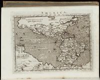
Beinecke Rare Book and Manuscript Library > America
Call Number:
1977 1341
Collection Title:
Geographiae vniversae opvs habentur Cl. Ptolemaei ... Geographicae enarationis libri octo [tr. by W
Image Count:
1
Resource Type:
Books, Journals & Pamphlets
Found in:
Beinecke Rare Book and Manuscript Library > America
Call Number:
1977 +379
Collection Title:
Geografia; cioe, Descrittione vniversale della terra. Partita in due volumi, nel primo de' quali si
Image Count:
1
Resource Type:
Books, Journals & Pamphlets
Found in:
Beinecke Rare Book and Manuscript Library > [Geographia. Italian]
Call Number:
Gfp94 +Gi597
Collection Title:
Geografia; cioe, Descrittione vniversale della terra. Partita in due volumi, nel primo de' quali si
Image Count:
1
Resource Type:
Books, Journals & Pamphlets
Found in:
Beinecke Rare Book and Manuscript Library > [Geographia. Italian]
Call Number:
1977 +246
Collection Title:
Geografia; cioè, Descrittione vniversale della terra. Partita in due volumi, nel primo de' quali si
Image Count:
1
Resource Type:
Books, Journals & Pamphlets
Found in:
Beinecke Rare Book and Manuscript Library > Descrittione dell-America, o dell'India Occidentale. America
Creator:
Call Number:
Art Storage 30cea 1555
Image Count:
2
Resource Type:
Maps, Atlases & Globes
Found in:
Beinecke Rare Book and Manuscript Library > [Portolan chart of the Mediterranean Sea, the North Atlantic Ocean, the Baltic Sea, and the northwestern African coast].
Call Number:
Osborn d119
Collection Title:
[Travel diary]
Image Count:
1
Resource Type:
Archives or Manuscripts
Found in:
Beinecke Rare Book and Manuscript Library > Plan de Geneve
Call Number:
Zc86 915yo
Collection Title:
Alaska days with John Muir / by S. Hall Young
Image Count:
1
Resource Type:
Maps, Atlases & Globes
Found in:
Beinecke Rare Book and Manuscript Library > Voyages of Muir and Young 1879 and 1880 in southeastern Alaska
Call Number:
Zc86 925te
Collection Title:
A journey to Alaska in the year 1868 : being a diary of the late Emil Teichmann / edited with an
Image Count:
1
Resource Type:
Books, Journals & Pamphlets
Found in:
Beinecke Rare Book and Manuscript Library > Voyage of the "Ocean Queen," Victoria to Sitka, 1868
Creator:
Published / Created:
undated
Call Number:
WA MSS 303
Collection Title:
Lewis and Clark Expedition maps and receipt, ca. 1803-1810
Container / Volume:
Box 2 | Folder 59r
Image Count:
1
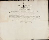
Found in:
Beinecke Rare Book and Manuscript Library > Printed form used by Captains during the Expedition: "Thomas Jefferson, President of the United States of America. From the powers vested in us and [blank] by the above authority: To all who shall see these presents, Greeting: Know ye, that from the spec
Creator:
Published / Created:
undated
Call Number:
WA MSS 303
Collection Title:
Lewis and Clark Expedition maps and receipt, ca. 1803-1810
Container / Volume:
Box 2 | Folder 57r
Image Count:
1
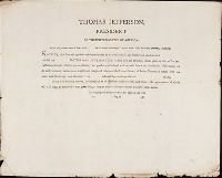
Found in:
Beinecke Rare Book and Manuscript Library > Printed form used by Captains during the Expedition: "Thomas Jefferson, President of the United States of America. From the powers vested in us and [blank] by the above authority: To all who shall see these presents, Greeting: Know ye, that from the spec
Creator:
Published / Created:
undated
Call Number:
WA MSS 303
Collection Title:
Lewis and Clark Expedition maps and receipt, ca. 1803-1810
Container / Volume:
Box 2 | Folder 53v
Image Count:
1
Found in:
Beinecke Rare Book and Manuscript Library > Draft of the mouth of the Columbia River and fragmented view of the coast
Creator:
Published / Created:
undated
Call Number:
WA MSS 303
Collection Title:
Lewis and Clark Expedition maps and receipt, ca. 1803-1810
Container / Volume:
Box 2 | Folder 52
Image Count:
2
Found in:
Beinecke Rare Book and Manuscript Library > Lewis's sketch-map of Vancouver's Island, Nootka Sound, etc
Creator:
Published / Created:
undated
Call Number:
WA MSS 303
Collection Title:
Lewis and Clark Expedition maps and receipt, ca. 1803-1810
Container / Volume:
Box 2 | Folder 51v
Image Count:
1
Found in:
Beinecke Rare Book and Manuscript Library > Draft of the mouth of the Columbia River and Haleys Bay [and] Draft of the mouth of the Columbia River and Point William
Creator:
Published / Created:
undated
Call Number:
WA MSS 303
Collection Title:
Lewis and Clark Expedition maps and receipt, ca. 1803-1810
Container / Volume:
Box 2 | Folder 49
Image Count:
2
Found in:
Beinecke Rare Book and Manuscript Library > Coastline south of the mouth of the Columbia River
Creator:
Published / Created:
undated
Call Number:
WA MSS 303
Collection Title:
Lewis and Clark Expedition maps and receipt, ca. 1803-1810
Container / Volume:
Box 2 | Folder 48
Image Count:
2
Found in:
Beinecke Rare Book and Manuscript Library > Area of the mouth of the Columbia River, southern side
Branch:v1.60.98 ,Deployed:2024-04-24T10:14:30-04:00