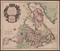
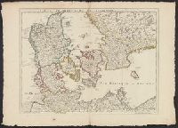
Copy 2: Mounted on linen. Sheet measures 57.3 x 79 cm. Ms. no. on verso: No. 6., Imprint date from Tooley., Includes descriptive text., and Relief shown pictorially.
Publisher:
Chez l'auteur sur le Quai de l'Horloge a l'Aigle d'Or,
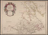
1st state of re-engraved, close copy of L'Isle's map of the same title (Kershaw 284)., According to Ke, According to Kershaw, this map is copied with only slight alteration from the Del'Isle map of Canada., Cross collection no. 169., and Relief shown pictorially.
Publisher:
chez Pierre Mortier,
Subject (Geographic):
Canada--Maps--Early works to 1800 and North America--Maps--Early works to 1800
Subject (Name):
L'Isle, Guillaume de, 1675-1726 and Ottens Joachim, 1663-1719
"Avec privilege Janvier 1708.", "The words 'premier geographe du Roi' added in the title ... [indicate] that [a map] could not have been issued before 1718 when [De l'Isle] was appointed to that office"--Tooley, R.V. Guide to maps, and Relief shown pictorially.
Publisher:
chez l'auteur sur le Quai de l'Horloge,
Subject (Geographic):
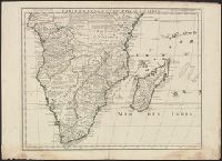
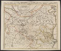
Africa, Central--Maps--Early works to 1800 and Africa, Southern--Maps--Early works to 1800
"Avec privil.", Backed with paper. Ms. no. "97" in upper right-hand corner. Sheet measures 53.6 x 63.5 cm. No. 87 of 87 maps bound together., Includes four bar scales., Includes inset: Carte particulière du Détroit de Magellan., Relief shown pictorially., and Untitled inset shows Southern Hemisphere.
Publisher:
Elizabeth Visscher,
Subject (Geographic):
Magellan, Strait of (Chile and Argentina)--Maps--Early works to 1800., South America--Maps--Early works to 1800., and Southern Hemisphere--Maps--Early works to 1800.
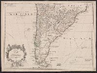
Appears in L'Isle's Atlas de géographie. Paris : Guillaume DeLisle, Quai de l'Horloge, 1731., Or, Relief shown pictorially., Sheet measures 54.9 x 74.6 cm., and Shows routes of Magellan, Sarmiento, Brower, Beauchesne, Sharp, Sr. de la Roche, Halley and Vespucci.
Publisher:
Chez l'auteur sur le Quai de l'Horloge ...,
Subject (Geographic):
South America--Maps--1708-1718 and South America--Maps--Early works to 1800
Subject (Name):
Liebaux, engraver, L'Isle, Guillaume de, 1675-1726. Atlas de géographie, and Simonneau, Charles, 1645-1728
Appears in L'Isle's Atlas de géographie. Paris : Guillaume DeLisle, Quai de l'Horloge, 1731., Imprint of Louis Renard Libraire, Mounted in linen. Sheet measures 51.8 x 69.7 cm., Ornamental cartouche by "C. Simonneau inv. et fecit.", and Relief shown pictorially.
Publisher:
Chez l'auteur sur le Quai de l'Horloge ...,
Subject (Geographic):
South America--Maps--1708-1718 and South America--Maps--Early works to 1800
Subject (Name):
Liebaux, engraver, L'Isle, Guillaume de, 1675-1726. Atlas de géographie, and Simonneau, Charles, 1645-1728
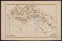
Neptune françois, ou, Atlas nouveau des cartes marines.
Description:
Appears in: Le Neptune françois, ou, Atlas nouveau des cartes marines, various eds., Covers coasts of Virginia, Maryland, Delaware, New, Described in Coolie Verner's Printed maps of Virginia, 1590-1800, p. 402., Nautical chart., and Oriented with north to right.
Publisher:
Chez P. Mortier,
Subject (Geographic):
Middle Atlantic States--Maps--Early works to 1800
Subject (Name):
Mortier, Pierre
Subject (Topic):
Coasts, Coasts--Delaware--Maps--Early works to 1800, Coasts--Maryland--Maps--Early works to 1800, Coasts--New Jersey--Maps--Early works to 1800, and Nautical charts--Chesapeake Bay (Md. and Va.)--Early works to 1800