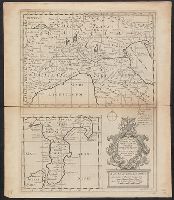
"Dedicated to His Highness William Duke of Glocester.", Appears in E. Wells' A new sett of maps both of antient and present geography., English, with Latin place names., Has watermark., Includes ornamental cartouche., and Relief shown pictorially.
Publisher:
s.n.,
Subject (Geographic):
Italy--Historical geography--Maps--Early works to 1800, Italy--History--To 476--Maps--Early works to 1800, and Rome--Maps--Early works to 1800
Subject (Name):
Nicholls, Sutton and Wells, Edward, 1667-1727. New sett of maps both of antient and present geography
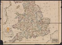
"To the Right Hono.ble William Connelly, Esq. One of the Commissioners of His Maj.ties Revenue, Speaker of the Hono.ble House of Commons and one of His Maj.ties most Hono.ble Privy Council for ye Kingdom of Ireland. This map is dedicated by John Senex.", From Senex's A new general atlas ... London : Printed for Daniel Browne ... [etc.], 1721., Imperfect: chipped and torn along folds, with no loss of text. Cross collection no. 73., and Relief shown pictorially.
Publisher:
I. Senex,
Subject (Geographic):
England--Maps--Early works to 1800, Great Britain--Maps--Early works to 1800, Scotland--Maps--Early works to 1800, and Wales--Maps--Early works to 1800
Subject (Name):
Connelly, William, dedicatee, Senex, John, d. 1740, dedicator, and Senex, John, d. 1740. New general atlas
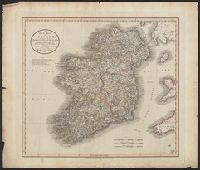
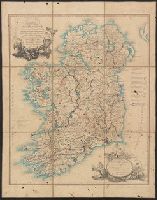
Bar scales given in English miles, 60 in a degree, Irish miles, 50 in a degree, and Dutch miles, 15 in a degree., Drawn from the survey made by Sr. Wm. Petty ; divided into its provinces, counties, and barronies, shewing also its bishopricks, borroughs, highwaies ... ; improved with many additions not extent in any other map., Includes inset map The sea coast of England, Scotland, and Ireland, Holland & part of France., No. 8 of 69 maps bound together in composite atlas., and Scale [ca. 1:540 000].
Publisher:
Sold by Rob. Morden at the Atlas in Corn-hil and by Christ. Brown at the Globe and Compasses in St. Pauls Churchyard