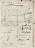
Bar scale in miles., From The London magazine, or, Gentleman's monthly intelligencer. Oct. 1762, v. 21., Hand col. Mounted on linen. S, In upper margin: For the London magazine 1762., and Includes indexed inset of "A plan of the harbour & town of Havana" and ill.
Publisher:
Printed for R. Baldwin,
Subject (Geographic):
Cuba--Maps--Early works to 1800
Subject (Name):
Baldwin, R. (Robert), 1737-1810, bookseller
Subject (Topic):
Nautical charts--Caribbean Sea--Early works to 1800
Map of the world showing routes of Cook's expeditions, with notes on ice, wild life etc. seen. Relief shown pictorially; imaginary coastline for eastern coast of Australian Bight., No. 1 of 43 maps bound together in composite atlas., and Scale [ca.1:68 000 000].
Publisher:
Published by Wm. Faden, Geographer to the King, Charing Cross
Subject (Name):
Cook, James, 1728-1779 and Mulgrave, Constantine John Phipps, Lord
Subject (Topic):
Discoveries in geography --Maps --To 1800 and World maps --Early works to 1800
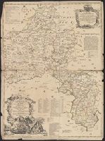
"Most humbly inscrib'd to ye most honoble. the Marquis of Annandale, kt. of the most noble & ancient Order of the Thistle.", Appears in the Senex's New general atlas. 1721., Includes ornamental cartouche., Prime meridian: London., and Relief shown pictorially.
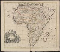
" R. Spoffort Sc.", Appears in "A new sett of maps both of ancient and present geography"., Relief shown pictorially., and Shows boundaries, rivers, deserts, caravan routes, and principal settlements, with unexplored areas.