Skip to search
Skip to main content
Skip to first result
Search
You Searched For
Date
-
Format
cartographic
New Search
Search Results
Creator:
Published / Created:
ca. 1855
Call Number:
WA Prints Folio 4
Container / Volume:
Report of explorations in California for railroad routes, to connect with the routes near the 35th and 32nd parallels of north latitude by Lieutenant R. S. Williamson1853. Volume V from Reports of explorations and surveys, to ascertain the most practicab
Image Count:
1
Found in:
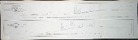
Beinecke Rare Book and Manuscript Library > [U.S.P.R.R. Exp. & Surveys. Ca.] Section 6. Sheet IV. Geological Section Along the Tejon Ravine Explored by Lieut R.S. Williamson Corps of Topl. Engrs. 1853 from the Tulare Valley and the Tejon Depot Camp to Taheechaypah Prairie Prepared in the Office of
Creator:
Published / Created:
ca. 1855
Call Number:
WA Prints Folio 2
Container / Volume:
Report of explorations in California for railroad routes, to connect with the routes near the 35th and 32nd parallels of north latitude by Lieutenant R. S. Williamson1853. Volume V from Reports of explorations and surveys, to ascertain the most practicab
Image Count:
1
Found in:
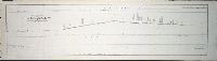
Beinecke Rare Book and Manuscript Library > [U.S.P.R.R. Exp. & Surveys. CAL.] Section 5, Sheet III. Geological Section of the Sierra Nevada at the Tejon Pass Explored by Lieut. R.S. Williamson Corps of Topl. Engrs. 1853 Prepared in the Office of Pacific Rail Road Explorations & Surveys War Departm
Published / Created:
1840-1844.
Call Number:
23 1844
Container / Volume:
BRBL_00020
Image Count:
3
Resource Type:
Maps, Atlases & Globes
Found in:
Beinecke Rare Book and Manuscript Library > [U.S. Exploring Expedition Pacific Ocean] Engraved by Sherman and Smith, New York. By the U.S. Ex.Ex.
Published / Created:
188-]
Call Number:
754GM 1880
Container / Volume:
BRBL_00419
Image Count:
1
Resource Type:
Maps, Atlases & Globes
Found in:
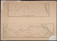
Beinecke Rare Book and Manuscript Library > [Two maps showing the southern Atlantic states to point out the transportation routes to the Seaboard Central and Seaboard Southern routes].
Published / Created:
1825
Call Number:
23cea 1825A
Container / Volume:
BRBL_00021
Image Count:
2
Resource Type:
Maps, Atlases & Globes
Found in:
Beinecke Rare Book and Manuscript Library > [Two charts of the Pacific Ocean, showing the Northwestern America and Sandwich Islands and ports].
Published / Created:
[1940?]
Call Number:
456 1940A
Container / Volume:
BRBL_00259
Image Count:
1
Resource Type:
Maps, Atlases & Globes
Found in:
Beinecke Rare Book and Manuscript Library > [Transylvania] / Entworfen von Robert Csallner.
Published / Created:
[1940?]
Call Number:
456 1918A
Container / Volume:
BRBL_00259
Image Count:
1
Resource Type:
Maps, Atlases & Globes
Found in:
Beinecke Rare Book and Manuscript Library > [Transylvania] / Entworfen von Robert Csallner.
Published / Created:
[1940?]
Call Number:
456 1918
Container / Volume:
BRBL_00259
Image Count:
1
Resource Type:
Maps, Atlases & Globes
Found in:
Beinecke Rare Book and Manuscript Library > [Transylvania] / Entworfen von Robert Csallner.
Published / Created:
1873?]
Call Number:
844cbf 1873A
Container / Volume:
BRBL_00613
Image Count:
1
Resource Type:
Maps, Atlases & Globes
Found in:
Beinecke Rare Book and Manuscript Library > [Topographical map of central California].
Published / Created:
[1940?-1941]
Call Number:
42 1940
Container / Volume:
BRBL_00244
Image Count:
13
Resource Type:
Maps, Atlases & Globes
Found in:
Beinecke Rare Book and Manuscript Library > [Topographical map of Austria. 1: 25,000].
Branch:v1.60.98 ,Deployed:2024-04-24T10:14:36-04:00