Skip to search
Skip to main content
Skip to first result
Search
You Searched For
Date
Unknown
"North America--Maps"
Format
cartographic
Date Created
[Missing]
New Search
Search Results
Creator:
Call Number:
1973 Folio 67
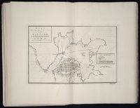
Collection Title:
The West-India pilot: containing piloting directions for Port Royal and Kingston harbours in
Image Count:
1
Subject (Geographic):
Atlantic Ocean --Maps --Early works to 1800, Cuba --Maps --Early works to 1800, Havana (Cuba) --Maps --Early works to 1800, and West Indies --Maps --Early works to 1800
Subject (Topic):
Harbors --Atlantic Coast (North America
Collection Created:
London : Printed for the author and sold by S. Hooper ..., MDCCLXXI [1771]
Found in:
Beinecke Rare Book and Manuscript Library > Plan of the harbour and city of Havanah
Call Number:
1973 Folio 67
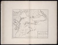
Collection Title:
The West-India pilot: containing piloting directions for Port Royal and Kingston harbours in
Image Count:
1
Subject (Geographic):
Atlantic Ocean --Maps --Early works to 1800, Jamaica --Maps --Early works to 1800, and West Indies --Maps --Early works to 1800
Subject (Topic):
Harbors --Atlantic Coast (North America
Collection Created:
London : Printed for the author and sold by S. Hooper ..., MDCCLXXI [1771]
Found in:
Beinecke Rare Book and Manuscript Library > Plan of the harbour of Port Royal in the island of Jamaica
Creator:
Call Number:
1973 Folio 67
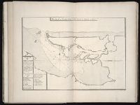
Collection Title:
The West-India pilot: containing piloting directions for Port Royal and Kingston harbours in
Image Count:
1
Subject (Geographic):
Atlantic Ocean --Maps --Early works to 1800, Puerto Rico --Maps --Early works to 1800, and West Indies --Maps --Early works to 1800
Subject (Topic):
Harbors --Atlantic Coast (North America
Collection Created:
London : Printed for the author and sold by S. Hooper ..., MDCCLXXI [1771]
Found in:
Beinecke Rare Book and Manuscript Library > Plan of the harbour of St. Juan de Port o Rico
Creator:
Call Number:
1973 Folio 67
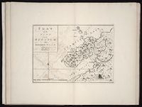
Collection Title:
The West-India pilot: containing piloting directions for Port Royal and Kingston harbours in
Image Count:
1
Subject (Geographic):
Atlantic Ocean --Maps --Early works to 1800 and Panama --Maps --Early works to 1800
Subject (Topic):
Harbors --Atlantic Coast (North America
Collection Created:
London : Printed for the author and sold by S. Hooper ..., MDCCLXXI [1771]
Found in:
Beinecke Rare Book and Manuscript Library > Plan of the town harbour of Puerto Vello
Creator:
Call Number:
1973 Folio 67
Collection Title:
The West-India pilot: containing piloting directions for Port Royal and Kingston harbours in
Image Count:
1
Subject (Geographic):
Atlantic Ocean --Maps --Early works to 1800 and Cartagena (Colombia) --Maps
Subject (Topic):
Harbors --Atlantic Coast (North America
Collection Created:
London : Printed for the author and sold by S. Hooper ..., MDCCLXXI [1771]
Found in:
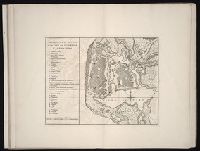
Beinecke Rare Book and Manuscript Library > References for the plan of the city and suburbs of Carthagena
Creator:
Call Number:
85 1735
Container / Volume:
BRBL_00636
Image Count:
1
Resource Type:
Maps, Atlases & Globes
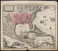
Description:
Manuscript number in upper right corner: 116., Relief shown pictorially., and Watermark.
Subject (Geographic):
North America --Maps --Early works to
Subject (Name):
Lotter, Tobias Conrad, 1717-1777, engraver
Found in:
Beinecke Rare Book and Manuscript Library > Mappa geographica regionem Mexicanam et Floridam : terrasque adjacentes, ut et Anteriores Americae insulas cursus itedem et reditus navigantium versus flumen Missisipi et alias colonias ob oculas ponens / cura et sumptibus Matthaei Seutteri ; Tob. Con. Lo
Creator:
Call Number:
1973 Folio 76
Collection Title:
The English pilot: describing the sea-coasts, capes, head-lands, rivers, bays, roads, havens
Image Count:
1
Description:
Most maps numbered in pencil on verso, some on recto.
Subject (Geographic):
North America --Maps --Early works to
Subject (Topic):
Navigation --Early works to 1800, Pilot guides --Atlantic Coast (U.S.) --Early works to 1800, and Pilot guides --Caribbean Area --Early works to 1800
Collection Created:
London : Printed for John Thornton, at the sign of the England, Scotland, and Ireland, in the Minories, and Richard Mount, at the Postern on Tower-Hill, 1698London : Printed for John Thornton, at the sign of the England, Scotland, and Ireland, in the Minories, and Richard Mount, at the Postern on Tower-Hill, 1698
Found in:
Beinecke Rare Book and Manuscript Library > A chart of ye north part of America
Call Number:
1974 Folio 72
Collection Title:
The English pilot: describing the West-India navigation, from Hudson's-Bay to the river Amazones
Image Count:
1
Subject (Geographic):
North America --Maps --Early works to
Subject (Topic):
Navigation --Early works to 1800, Pilot guides --Atlantic Coast (U.S.) --Early works to 1800, and Pilot guides --Caribbean Area --Early works to 1800
Collection Created:
London : Printed for W. and J. Mount, T. Page and son, on Tower-Hill, MDCCLX [1760]
Found in:
Beinecke Rare Book and Manuscript Library > A new and correct chart of the western and southern oceans
Call Number:
1973 Folio 116
Collection Title:
The English pilot: describing the West-India navigation, from Hudson's-Bay to the river Amazones
Image Count:
2
Subject (Geographic):
North America --Maps --Early works to
Subject (Topic):
Navigation --Early works to 1800, Pilot guides --Atlantic Coast (U.S.) --Early works to 1800, and Pilot guides --Caribbean Area --Early works to 1800
Collection Created:
London :
Found in:
Beinecke Rare Book and Manuscript Library > A new and correct chart of the western and southern oceans
Call Number:
1973 Folio 114
Collection Title:
The English pilot: describing the West-India navigation, from Hudson's-Bay to the river Amazones
Image Count:
1
Resource Type:
Maps, Atlases & Globes
Subject (Geographic):
North America --Maps --Early works to
Subject (Topic):
Navigation --Early works to 1800, Pilot guides --Atlantic Coast (U.S.) --Early works to 1800, and Pilot guides --Caribbean Area --Early works to 1800
Collection Created:
London : Printed for W. and J. Mount, T. Page and son, on Tower-Hill, MDCCLIX [1759]
Found in:
Beinecke Rare Book and Manuscript Library > A new and correct chart of the western and southern oceans ...
Branch:v1.61.6 ,Deployed:2024-06-12T09:55:37-04:00