- Creator:
- Colorado Midland Railway Company
- Published / Created:
- undated
- Call Number:
- WA MSS S-1741 BrSides
- Collection Title:
- Colorado Midland Railway Company maps
- Container / Volume:
- Folder 2
- Image Count:
- 10
- Resource Type:
- Maps, Atlases & Globes
- Description:
- Folder includes indes of maps on ledger paper, 44 x 56 cm. and Versos blank, not digitized.
- Subject (Geographic):
- Colorado--Maps, Garfield County (Colo.)--Maps, and Glenwood Springs (Colo.)--Maps
- Subject (Name):
- Colorado Midland Railway Company
- Subject (Topic):
- Mines and mineral resources--Colorado--Maps and Railroads--Colorado--Maps
- Found in:
- Beinecke Rare Book and Manuscript Library > [Maps of Garfield County, Colorado]
You Searched For
« Previous
| 501 - 510 of 510 |
Next »
Search Results
- Creator:
- Colorado Midland Railway Company
- Published / Created:
- undated
- Call Number:
- WA MSS S-1741 BrSides
- Collection Title:
- Colorado Midland Railway Company maps
- Container / Volume:
- Folder 1
- Image Count:
- 8
- Resource Type:
- Maps, Atlases & Globes
- Abstract:
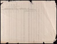
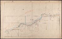
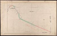
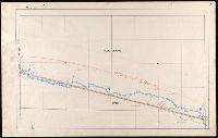
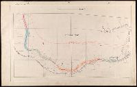
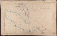
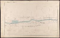
- 107 colored manuscript railroad maps, detailing the line of the Colorado Midland Railway between Park County and Pitkin and Garfield Counties. The highly detailed maps depict county ranges and townships, survey points and mileage markers, depots, canyons, bridges, sidings, trestles, tunnels, rivers, creeks, etc.; adjacent railroad lines and rights-of-way; hamlets, villages, settlements, ranches, farms, etc.; and plats of the towns of Buena Vista, Leadville, Glenwood Springs, and Aspen. Counties covered are Chaffee, Eagle, Garfield, Lake, Park, and Pitkin. Accompanied by an incomplete index (1 leaf) entitled "Valuation Section [?] Colo. Midland Ry" and two leaves of surveying notes.
- Description:
- Versos blank, not digitized.
- Subject (Geographic):
- Colorado--Maps and Garfield County (Colo.)--Maps
- Subject (Name):
- Colorado Midland Railway Company
- Subject (Topic):
- Mines and mineral resources--Colorado--Maps and Railroads--Colorado--Maps
- Found in:
- Beinecke Rare Book and Manuscript Library > [Maps of Garfield County, Colorado]
- Creator:
- Colorado Midland Railway Company
- Published / Created:
- undated
- Call Number:
- WA MSS S-1741 BrSides
- Collection Title:
- Colorado Midland Railway Company maps
- Container / Volume:
- Folder 3
- Image Count:
- 15
- Resource Type:
- Maps, Atlases & Globes
- Description:
- Versos blank, not digitized.
- Subject (Geographic):
- Colorado--Maps, Lake County (Colo.)--Maps, and Leadville (Colo.)--Maps
- Subject (Name):
- Colorado Midland Railway Company
- Subject (Topic):
- Mines and mineral resources--Colorado--Maps and Railroads--Colorado--Maps
- Found in:
- Beinecke Rare Book and Manuscript Library > [Maps of Lake County, Colorado]
- Creator:
- Colorado Midland Railway Company
- Published / Created:
- undated
- Call Number:
- WA MSS S-1741 BrSides
- Collection Title:
- Colorado Midland Railway Company maps
- Container / Volume:
- Folder 4
- Image Count:
- 11
- Resource Type:
- Maps, Atlases & Globes
- Description:
- Versos blank, not digitized.
- Subject (Geographic):
- Buena Vista (Colo.)--Maps, Colorado--Maps, and Park County (Colo.)--Maps
- Subject (Name):
- Colorado Midland Railway Company
- Subject (Topic):
- Mines and mineral resources--Colorado--Maps and Railroads--Colorado--Maps
- Found in:
- Beinecke Rare Book and Manuscript Library > [Maps of Park and Chaffee Counties, Colorado]
- Creator:
- Colorado Midland Railway Company
- Published / Created:
- undated
- Call Number:
- WA MSS S-1741 BrSides
- Collection Title:
- Colorado Midland Railway Company maps
- Container / Volume:
- Folder 5
- Image Count:
- 12
- Resource Type:
- Maps, Atlases & Globes
- Description:
- Versos blank, not digitized. and Wanting Chaffee County Map 1[?]
- Subject (Geographic):
- Buena Vista (Colo.)--Maps, Chaffee County (Colo.)--Maps, Colorado--Maps, and Park County (Colo.)--Maps
- Subject (Name):
- Colorado Midland Railway Company
- Subject (Topic):
- Mines and mineral resources--Colorado--Maps and Railroads--Colorado--Maps
- Found in:
- Beinecke Rare Book and Manuscript Library > [Maps of Park and Chaffee Counties, Colorado]
- Creator:
- Colorado Midland Railway Company
- Published / Created:
- undated
- Call Number:
- WA MSS S-1741 BrSides
- Collection Title:
- Colorado Midland Railway Company maps
- Container / Volume:
- Folder 6
- Image Count:
- 13
- Resource Type:
- Maps, Atlases & Globes
- Description:
- Versos blank, not digitized.
- Subject (Geographic):
- Buena Vista (Colo.)--Maps, Chaffee County (Colo.)--Maps, and Colorado--Maps
- Subject (Name):
- Colorado Midland Railway Company
- Subject (Topic):
- Mines and mineral resources--Colorado--Maps and Railroads--Colorado--Maps
- Found in:
- Beinecke Rare Book and Manuscript Library > [Maps of Park and Chaffee Counties, Colorado]
- Creator:
- Colorado Midland Railway Company
- Published / Created:
- undated
- Call Number:
- WA MSS S-1741 BrSides
- Collection Title:
- Colorado Midland Railway Company maps
- Container / Volume:
- Folder 7
- Image Count:
- 10
- Resource Type:
- Maps, Atlases & Globes
- Description:
- Versos blank, not digitized.
- Subject (Geographic):
- Colorado--Maps, Eagle County (Colo.)--Maps, and Pitkin County (Colo.)--Maps
- Subject (Name):
- Colorado Midland Railway Company
- Subject (Topic):
- Mines and mineral resources--Colorado--Maps and Railroads--Colorado--Maps
- Found in:
- Beinecke Rare Book and Manuscript Library > [Maps of Pitkin and Eagle Counties, Colorado]
- Creator:
- Colorado Midland Railway Company
- Published / Created:
- undated
- Call Number:
- WA MSS S-1741 BrSides
- Collection Title:
- Colorado Midland Railway Company maps
- Container / Volume:
- Folder 8
- Image Count:
- 11
- Resource Type:
- Maps, Atlases & Globes
- Description:
- Versos blank, not digitized.
- Subject (Geographic):
- Colorado--Maps, Eagle County (Colo.)--Maps, and Pitkin County (Colo.)--Maps
- Subject (Name):
- Colorado Midland Railway Company
- Subject (Topic):
- Mines and mineral resources--Colorado--Maps and Railroads--Colorado--Maps
- Found in:
- Beinecke Rare Book and Manuscript Library > [Maps of Pitkin and Eagle Counties, Colorado]
- Published / Created:
- n.d.
- Call Number:
- WA MSS S-1737
- Collection Title:
- Paul Kagan utopian communities collection
- Container / Volume:
- 38 (Oversize) | Folder 693
- Image Count:
- 2
- Description:
- Stamped and signed: Watson E. Coleman.
- Subject (Name):
- Llano Colony (Secular community)
- Subject (Topic):
- Collective settlements--Louisiana--Vernon County
- Found in:
- Beinecke Rare Book and Manuscript Library > Map of the Llano Cooperative Colony (in Series I)
- Creator:
- Keller, Josiah P., 1812-1862
- Published / Created:
- Undated
- Call Number:
- WA MSS 280
- Container / Volume:
- Box 1 | Folder 9
- Image Count:
- 2
- Abstract:
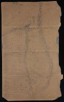
- This collection documents the establishment and early years of the Puget Mill Company, which manufactured lumber. The bulk of the papers are letters from Josiah Keller to his partner, Charles Foster. They discuss building plans, business development, ships and cargoes, and accounts. There are occasional mentions of Keller's personal affairs and one letter describes his voyage around Cape Horn in the schooner L. P. Foster. Two charts show Hood's Canal, the harbor, and location of the mill.
- Alternative Title:
- Puget Mill Company, 2 charts
- Description:
- Capt. Josiah P. Keller, of East Machias, Maine, was a founder of the Puget Mill Company. He sailed on the Julius Pringle from San Francisco to Puget Sound where he chose Port Gamble as a site for the mill. Keller became superintendent of the mill and in 1853 moved his family to Port Gamble.
- Subject (Geographic):
- Port Gamble (Wash.), Puget Sound (Wash.), and Washington (State)--Economic conditions
- Subject (Name):
- Foster, Charles,--d. 1876, Julius Pringle (Ship), Keller, Josiah P.,--1812-1862, L. P. Foster (Schooner), Pope, Andrew J, Puget Mill Company, and Talbot, William C
- Subject (Topic):
- Lumbering--Washington (State)
- Found in:
- Beinecke Rare Book and Manuscript Library > Josiah P. Keller papers, 1853-1862.