Search
You Searched For
Search Results
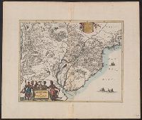
- Call Number:
- 1976 1233
- Collection Title:
- Forty-two new maps of Asia, Africa, and America ... : all engrav’d, according to the latest
- Image Count:
- 1
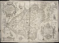
- Subject (Geographic):
- Brazil --Maps --Early works to 1800
- Found in:
- Beinecke Rare Book and Manuscript Library > A map of Brasil and part of La Plata &c
- Published / Created:
- 1602
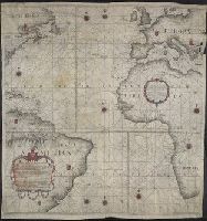
- Call Number:
- Taylor 228
- Collection Title:
- Eigentliche vnd warhafftige Beschreibung / der wunderbaerlichen Schiffarth (der Hollaender
- Image Count:
- 1
- Subject (Geographic):
- Brazil --Maps --Early works to 1800
- Found in:
- Beinecke Rare Book and Manuscript Library > Deliniatio orarum Peru ...
- Published / Created:
- 1671]
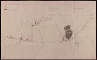
- Call Number:
- 919 1671
- Container / Volume:
- BRBL_00673
- Image Count:
- 1
- Resource Type:
- Maps, Atlases & Globes
- Description:
- , Brazil; settlements of various types, towns
- Found in:
- Beinecke Rare Book and Manuscript Library > Paraqvaria, vulgo Paragvay. Cum adjacentibus.
- Creator:
- Pinheiro, Simão Antônio da Rosa
- Published / Created:
- anno de 1786.
- Call Number:
- Art Storage 1006
- Container / Volume:
- BRBL_00700
- Image Count:
- 1
- Resource Type:
- Maps, Atlases & Globes
- Description:
- Terra do Estado do Brazil."
- Found in:
- Beinecke Rare Book and Manuscript Library > Carta reduzida, e em muijte parte reformada, pelas observacoens mais justificadas dos melhores authores, astronomos modernos, [que] pareceraõ mais coherentes, pelas exaetissimas averiguacoens de pilotos eruditos, e do roterro portugues : em que se compre
- Published / Created:
- 1919 Nov 18
- Call Number:
- WA MSS S-1326
- Collection Title:
- Ernest Howe papers
- Container / Volume:
- BSD | Folder 269
- Image Count:
- 4
- Resource Type:
- Maps, Atlases & Globes
- Subject (Geographic):
- Brazil--Pictorial works.
- Found in:
- Beinecke Rare Book and Manuscript Library > Oriental Mine report by Robert Bedford, maps
- Published / Created:
- 1913, n.d.
- Call Number:
- WA MSS S-1326
- Collection Title:
- Ernest Howe papers
- Container / Volume:
- BSD | Folder 268
- Image Count:
- 2
- Resource Type:
- Maps, Atlases & Globes
- Subject (Geographic):
- Brazil--Pictorial works.
- Found in:
- Beinecke Rare Book and Manuscript Library > Reports on the Tightner Mine, maps (EH)
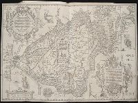
- Creator:
- Langren, Arnold Florent van, 1580-1644
- Published / Created:
- [ca. 1596]
- Call Number:
- Taylor 219
- Collection Title:
- Navigatio ac itinerarivm Iohannis Hvgonis Linscotani in Orientalem sive Lvsitanorvm Indiam
- Image Count:
- 1
- Subject (Geographic):
- Brazil --Maps --Early works to 1800
- Found in:
- Beinecke Rare Book and Manuscript Library > Delineatio omnium orarum totius Australis partis Americae, dictae Peruvianae, a R. de la Plata, Brasiliam, Pariam, & Castellam ...
- Creator:
- Langren, Arnold Florent van, 1580-1644
- Published / Created:
- [ca. 1596]
- Call Number:
- Pequot +L65
- Collection Title:
- Nauigatio ac itinerarium Iohannis Hugonis Linscotani in Orientalem siue Lusitanorum Indiam
- Image Count:
- 1
- Subject (Geographic):
- Brazil --Maps --Early works to 1800
- Found in:
- Beinecke Rare Book and Manuscript Library > Delineatio omnium orarum totius Australis partis Americae, dictae Peruvianae, a R. de la Plata, Brasiliam, Pariam, & Castellam ...
- Creator:
- Godbid, Anne, printer.
Playford, John, ca. 1655-1685 or 6, printer.
Seller, John, fl. 1658-1698, bookseller
Seller, John, fl. 1658-1698.
- Published / Created:
- 1682
- Call Number:
- Taylor 384
- Image Count:
- 50
- Found in:
- Beinecke Rare Book and Manuscript Library > Atlas maritimus, or, A sea-atlas : describing the sea-coasts in most of the known parts of the world / by John Seller, hydrographer to the King
- Creator:
- Robijn, Jacobus, d. ca. 1710
- Published / Created:
- [1683?]
- Call Number:
- 21 1683
- Container / Volume:
- BRBL_00682
- Image Count:
- 1
- Resource Type:
- Maps, Atlases & Globes
- Subject (Geographic):
- Brazil--Maps--Early works to 1800
- Found in:
- Beinecke Rare Book and Manuscript Library > Pascaarte vande zee custen van Guinea en Brasilias van Cabo de Verde, tot C. de bona Esperanca en van R. de Amazones tot Rio de la Plata, alles op wassende graaden gestelt [cartographic material].