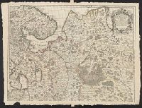
From Aa's Nouvel Atlas ... A Leide : Chez Pierre Van der Aa ..., [1714], Mounted on paper. Sheet measures 29.8 x 36 cm. Cross Collection no. 165., and Relief shown pictorially.
Buache, Philippe, 1700-1773 Liebaux, Henri, engraver L'Isle, Guillaume de, 1675-1726
Published / Created:
1706 [i.e. 1745]
Call Number:
352 1745
Container / Volume:
BRBL_00104
Image Count:
2
Resource Type:
Maps, Atlases & Globes
Description:
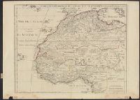
Bar scales given in "verstes, In bottom margin of sheet 2: Ph[ilippe] Buache, p[remier] g[éographe] d[u] R[oy]; d[e] l'A[cadémie] r[oyale] d[es] s[ciences]. Gendre de l'auteur. Avec privilége du 30 av[ril] 1745., and Sheets 54 x 71 cm. or smaller.
"Avec privil, "The words 'premier geographe du Roi' added in the title ... [indicate] that [a map] could not have been issued before 1718 when [De l'Isle] was appointed to that office"--Tooley, R.V. Guide to maps of Africa, p. 68., and Relief shown pictorially.
Publisher:
chez l'auteur fur le Quai de l'Horloge a l'Aigle d'Or,
Subject (Geographic):
Africa, North--Maps--Early works to 1800 and Africa, West--Maps--Early works to 1800
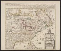
Insets: Les environs de Quebec -- Veüe de Quebec -- Les costes de la Louisiane., Relief shown pictorially., Same title appears in description of Chatelain's Atlas historique, 1732-39 ed., in Phillips' A list of geographical atlases ..., 579., and Yale's copy st
Publisher:
Châtelain?,
Subject (Geographic):
New France--Maps--Early works to 1800 and North America--Maps--Early works to 1800
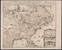
Includes inset of "Les costes de la Louisiane ....", Relief shown pictorially., and Yale's copy annotated in pencil with "circa 1760" on recto and "ca. 1720" on verso.
Publisher:
s.n.?,
Subject (Geographic):
New France--Maps--Early works to 1800 and North America--Maps--Early works to 1800
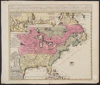
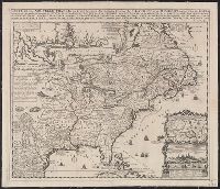
Appears in Chatelain's Atlas historique according to McCorkle., Cross collection no. 149., In upper right: Tom: VI. No: 23. Pag: 91., Includes notes, table of coordinates for certain locations, and ill., and Insets: Les environs de Quebec -- Veüe de Quebec -- Les costes de la Louisiane.
Publisher:
Chez L'Honoré & Châtelain Libraires?,
Subject (Geographic):
New France--Maps--Early works to 1800 and North America--Maps--Early works to 1800
Appears in Chatelain's Atlas historique according to McCorkle., Cross collection no. 149., In upper right: Tom: VI. No: 23. Pag: 91., Includes notes, table of coordinates for certain locations, and ill., McCorkle attributes authorshi, and Relief shown pictorially.
Publisher:
Chez L'Honoré & Châtelain Libraires?,
Subject (Geographic):
New France--Maps--Early works to 1800 and North America--Maps--Early works to 1800