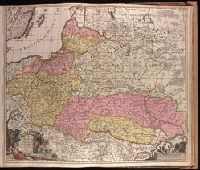
"Cum privilegio ordinum Hollandiae & Westfrisie.", Backed with paper. Sheet measures 53.8 x 62.3 cm. No. 79 of 87 maps bound together., Bar scales given in "milliaria Germanica" and "milliaria Gallica.", and Relief shown pictorially.
Publisher:
[Gerard van Keulen,
Subject (Geographic):
Baltic States--Maps--Early works to 1800., Poland--Maps--Early works to 1800., and Ukraine--Maps--Early works to 1800.
Mortier, David Mortier, Pierre Sanson, Nicolas, 1600-1667, creator
Published / Created:
[1710]
Call Number:
1973 Folio 10
Image Count:
1
Resource Type:
Maps, Atlases & Globes
Alternative Title:
Premiere carte de la Meuse avec les pais, duchez et comtez voisins and Teatre de la guerre en Flandre et Brabant
Description:
Alternate title in upper margin: Premiere carte de la Meuse avec les pais, duchez et comtez voisins., Does not show troop positions or other military locations., Ferro meridian., Imperfect: western sheet (with title cartouche) wanting. Part of eastern map (inset of Arras/Cambrai region) pasted over correction[?]., Includes inset of Arras/Cambrai region and color illustration of battles at upper left and lower right., No. 47 of 69 maps bound together in composite atlas., Originally printed on 4 sheets., Presentee a son altesse Monseigneur le Duc & Comte [sic] de Marlborough, Marquis de Blandford, &c. &c. &c., par son tres-humble et tres-obeissant serviteur, Pierre Mortier, libraire a Amsterdam., Relief shown pictorially., and Scale [ca. 1:250 000].
Publisher:
Apud Petrum Mortier, et se vend a Londres chez David Mortier
Subject (Topic):
Spanish Succession, War of, 1701-1714 --Maps --Early works to 1800
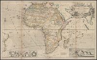
"According to the newest and most exact observations.", Includes views of "Cape Coast Castle on ye gold coast of Guinea," "James Fort on the island of St. Helena," and "A prospect of the Cape of Good Hope," and a plan of, and Prime meridians: London and Ferro.
Publisher:
Printed for H. Moll over against Devereux Court without Temple Bar, D. Midwinter at the 3 Crowns in St. Pauls church yard and Tho. Bowles print and mapseller next to the chapter house in St. Pauls church yard by Philip Overton, map and printseller near St
Subject (Geographic):
Africa--Maps--Early works to 1800
Subject (Name):
Bowles, Thomas, -1767, Midwinter, Daniel, active 1698-1725, and Overton, Philip, -1751
America occidentalium indiarum nomine Vulgo celebratissima non i[m]merito Europa Nova appellari posset
Description:
1st state, with California shown as a peninsula., Appears in Homann's Atlas novus., Imperfect: upper right corner mutilated, with some loss of text. Sheet measures 51.6 x 58.9 cm. Ms. note on verso: 6. Cross Collection no. 128., Prime meridian: Teneriffe., and Relief shown pictorially.